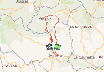
![](/images/other/stat-length.png)
![Tocht Stappen Minerve - 34-Minerve : les gorges du Briant (31/05/2015)* - Photo](https://media.geolcdn.com/t/1900/400/ext.pjpeg?maxdim=2&url=https%3A%2F%2Fstatic1.geolcdn.com%2Fsiteimages%2Fupload%2Ffiles%2F1553511878bg_sport_marche.png)
34-Minerve : les gorges du Briant (31/05/2015)*
Jovila
Gebruiker
![Lengte](/images/other/stat-length.png)
![Max. hoogte](https://static1.geolcdn.com/siteimages/upload/files/1508320355ic_sort_altitude_max_24dp.png)
![Positief hoogteverschil](https://static1.geolcdn.com/siteimages/upload/files/1508320355ic_sort_den_pos_24dp.png)
![Km-Effort](/images/other/stat-length.png)
![Min. hoogte](https://static1.geolcdn.com/siteimages/upload/files/1508320355ic_sort_altitude_min_24dp.png)
![Negatief hoogteverschil](https://static1.geolcdn.com/siteimages/upload/files/1508320355ic_sort_den_neg_24dp.png)
![Boucle](https://static1.geolcdn.com/siteimages/upload/files/16400158638029165_repeat_loop_refresh_sync_direction_icon.png)
![Stappen](https://static1.geolcdn.com/sitytour/trail-icons/101.png)
4h20
Moeilijkheid : Moeilijk
![Scan deze QR-code om de tocht te openen in de SityTrail-applicatie](https://capi.geolives.com/qq0zvz2zws4bq2lad0pu/sitytour/trails/428030/qr.png?size=200)
Gratisgps-wandelapplicatie
Over ons
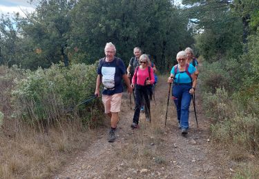
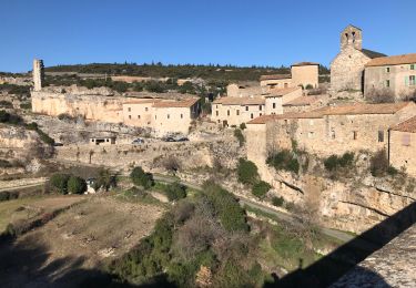
Tocht Stappen van 14 km beschikbaar op Occitanië, Hérault, Minerve. Deze tocht wordt voorgesteld door Jovila.
Beschrijving
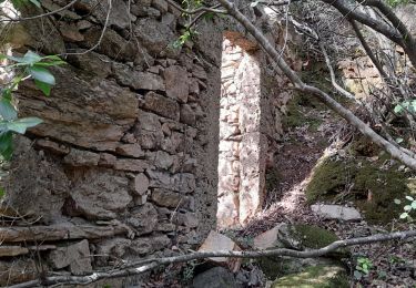
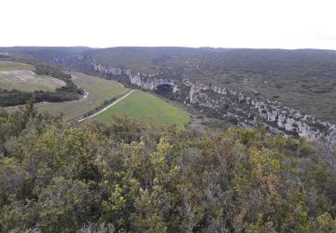
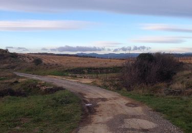
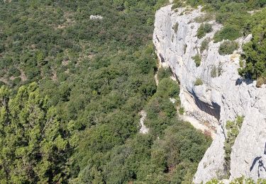
Point de départ : du parking payant au dessus du village, prendre la rue qui descend vers celui à l'épingle à cheveux prendre le chemin à gauche (passage dangereux interdit) nous l'avons pris quand même (éviter de vous y aventurer avec des enfants ou personnes sujettes au vertige,et avec du vent).
Plaatsbepaling
Opmerkingen
Wandeltochten in de omgeving
![Tocht Stappen Cesseras - Grotte Aldène Cesseras - Photo](https://media.geolcdn.com/t/375/260/fbc77cc8-93f1-4b6b-b038-073024d6a586.jpg&format=jpg&maxdim=2)
![Stappen Stappen](https://static1.geolcdn.com/sitytour/trail-icons/101.png)
Stappen
![](/images/other/stat-length.png)
![](https://static1.geolcdn.com/siteimages/upload/files/16400158638029165_repeat_loop_refresh_sync_direction_icon.png)
![Tocht Stappen Cesseras - 2023-04-08_21h30m21_Cesseras 10kms - Photo](https://media.geolcdn.com/t/375/260/63ef11e1-9828-4e19-8811-ad8eeda1adef.jpg&format=jpg&maxdim=2)
![Stappen Stappen](https://static1.geolcdn.com/sitytour/trail-icons/101.png)
Stappen
![](/images/other/stat-length.png)
![](https://static1.geolcdn.com/siteimages/upload/files/16400158638029165_repeat_loop_refresh_sync_direction_icon.png)
![Tocht Stappen Aigne - Aigne - Saume Longue - Photo](https://media.geolcdn.com/t/375/260/ext.jpg?maxdim=2&url=https%3A%2F%2Fservices.sitytrail.com%2FGeolivesWS%2FDownloadMedia.ashx%3FTrailID%3D373254%26Media%3D20141229163850.jpg)
![Stappen Stappen](https://static1.geolcdn.com/sitytour/trail-icons/101.png)
Stappen
![](/images/other/stat-length.png)
![](https://static1.geolcdn.com/siteimages/upload/files/16400158638029165_repeat_loop_refresh_sync_direction_icon.png)
![Tocht Stappen La Caunette - La Caunette - Photo](https://media.geolcdn.com/t/375/260/18583847-6773-463a-b6f4-5c9be80f48ff.jpg&format=jpg&maxdim=2)
![Stappen Stappen](https://static1.geolcdn.com/sitytour/trail-icons/101.png)
Stappen
![](/images/other/stat-length.png)
![](https://static1.geolcdn.com/siteimages/upload/files/16400158638029165_repeat_loop_refresh_sync_direction_icon.png)
![Tocht sport Minerve - Minerve bouclé Hérault - Photo](https://media.geolcdn.com/t/375/260/d578c921-3c99-4e11-b589-7310c0cb7ada.jpg&format=jpg&maxdim=2)
sport
![](/images/other/stat-length.png)
![](https://static1.geolcdn.com/siteimages/upload/files/16400158638029165_repeat_loop_refresh_sync_direction_icon.png)
![Tocht Stappen Minerve - Les dolmens de Vieulac - Photo](https://media.geolcdn.com/t/375/260/196751be-1369-4baa-8673-7b511991989e.jpg&format=jpg&maxdim=2)
![Stappen Stappen](https://static1.geolcdn.com/sitytour/trail-icons/101.png)
Stappen
![](/images/other/stat-length.png)
![](https://static1.geolcdn.com/siteimages/upload/files/16400158638029165_repeat_loop_refresh_sync_direction_icon.png)
![Tocht Stappen Azillanet - Azillanet Minerve - Photo](https://media.geolcdn.com/t/375/260/17a8c3f2-392a-4950-a09a-5c0f5e3f5c78.jpg&format=jpg&maxdim=2)
![Stappen Stappen](https://static1.geolcdn.com/sitytour/trail-icons/101.png)
Stappen
![](/images/other/stat-length.png)
![](https://static1.geolcdn.com/siteimages/upload/files/16400158638029165_repeat_loop_refresh_sync_direction_icon.png)
![Tocht Stappen La Caunette - La Caunette - Photo](https://media.geolcdn.com/t/375/260/023ef97f-7396-4efd-82f5-9f38cf32c62c.jpg&format=jpg&maxdim=2)
![Stappen Stappen](https://static1.geolcdn.com/sitytour/trail-icons/101.png)
Stappen
![](/images/other/stat-length.png)
![](https://static1.geolcdn.com/siteimages/upload/files/16400158638029165_repeat_loop_refresh_sync_direction_icon.png)
![Tocht Mountainbike Minerve - minerve - Photo](https://media.geolcdn.com/t/375/260/99c6c1a4-f768-4c35-9e57-edeb97d705f4.jpg&format=jpg&maxdim=2)
![Mountainbike Mountainbike](https://static1.geolcdn.com/sitytour/trail-icons/202.png)