![](/images/other/stat-length.png)
![Tocht Stappen Fleury - Fleury d'Aude - Château Laquirou - 11 km - Photo](https://media.geolcdn.com/t/1900/400/ext.pjpeg?maxdim=2&url=https%3A%2F%2Fservices.sitytrail.com%2FGeolivesWS%2FDownloadMedia.ashx%3FTrailID%3D426181%26Media%3Dfix__20150526160205.jpg)
Fleury d'Aude - Château Laquirou - 11 km
coco03
Gebruiker
![Lengte](/images/other/stat-length.png)
Lengte
10,8 km
![Max. hoogte](https://static1.geolcdn.com/siteimages/upload/files/1508320355ic_sort_altitude_max_24dp.png)
Max. hoogte
103 m
![Positief hoogteverschil](https://static1.geolcdn.com/siteimages/upload/files/1508320355ic_sort_den_pos_24dp.png)
Positief hoogteverschil
142 m
![Km-Effort](/images/other/stat-length.png)
Km-Effort
12,7 km
![Min. hoogte](https://static1.geolcdn.com/siteimages/upload/files/1508320355ic_sort_altitude_min_24dp.png)
Min. hoogte
4 m
![Negatief hoogteverschil](https://static1.geolcdn.com/siteimages/upload/files/1508320355ic_sort_den_neg_24dp.png)
Negatief hoogteverschil
140 m
![Boucle](https://static1.geolcdn.com/siteimages/upload/files/16400158638029165_repeat_loop_refresh_sync_direction_icon.png)
Boucle
Ja
Datum van aanmaak :
2017-01-01 00:00:00.0
Laatste wijziging :
2017-01-01 00:00:00.0
![Stappen](https://static1.geolcdn.com/sitytour/trail-icons/101.png)
2h50
Moeilijkheid : Gemakkelijk
![Scan deze QR-code om de tocht te openen in de SityTrail-applicatie](https://capi.geolives.com/qq0zvz2zws4bq2lad0pu/sitytour/trails/426181/qr.png?size=200)
Gratisgps-wandelapplicatie
Over ons
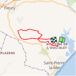
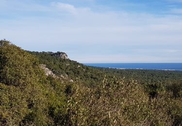
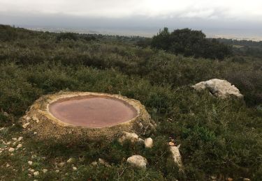
Tocht Stappen van 10,8 km beschikbaar op Occitanië, Aude, Fleury. Deze tocht wordt voorgesteld door coco03.
Beschrijving
Départ du domaine de l'Oustalet (Grand parking, cartes...) Dégustation possible au Château Laquirou (Vignoble en agriculture Biologique)
Plaatsbepaling
Land:
France
Regio :
Occitanië
Departement/Provincie :
Aude
Gemeente :
Fleury
Locatie:
Unknown
Vertrek:(Dec)
Vertrek:(UTM)
515465 ; 4782744 (31T) N.
Opmerkingen
Wandeltochten in de omgeving
![Tocht Stappen Fleury - Le Gouffre de l'oeil Doux - Photo](https://media.geolcdn.com/t/375/260/ext.jpg?maxdim=2&url=https%3A%2F%2Fservices.sitytrail.com%2FGeolivesWS%2FDownloadMedia.ashx%3FTrailID%3D108539%26Media%3D1438_2.jpg)
![Stappen Stappen](https://static1.geolcdn.com/sitytour/trail-icons/101.png)
Le Gouffre de l'oeil Doux
Stappen
Medium
(5)
Fleury,
Occitanië,
Aude,
France
![](/images/other/stat-length.png)
4,4 km | 5,3 km-effort
1h 30min
![](https://static1.geolcdn.com/siteimages/upload/files/16400158638029165_repeat_loop_refresh_sync_direction_icon.png)
Ja
![Tocht Stappen Fleury - Saint Pierre la mer Gouffre de l'oeil doux - Photo](https://media.geolcdn.com/t/375/260/42a9e24a-cb10-496f-8af4-f668f7bd7981.jpg&format=jpg&maxdim=2)
![Stappen Stappen](https://static1.geolcdn.com/sitytour/trail-icons/101.png)
Saint Pierre la mer Gouffre de l'oeil doux
Stappen
Gemakkelijk
Fleury,
Occitanië,
Aude,
France
![](/images/other/stat-length.png)
16,8 km | 19,8 km-effort
4h 13min
![](https://static1.geolcdn.com/siteimages/upload/files/16400158638029165_repeat_loop_refresh_sync_direction_icon.png)
Ja
![Tocht Stappen Fleury - 20221230 boucle Oustalet-Fleury(1) - Photo](https://media.geolcdn.com/t/375/260/5108ae19-254d-467a-8819-14627131e853.jpg&format=jpg&maxdim=2)
![Stappen Stappen](https://static1.geolcdn.com/sitytour/trail-icons/101.png)
20221230 boucle Oustalet-Fleury(1)
Stappen
Gemakkelijk
Fleury,
Occitanië,
Aude,
France
![](/images/other/stat-length.png)
10,6 km | 12,6 km-effort
2h 17min
![](https://static1.geolcdn.com/siteimages/upload/files/16400158638029165_repeat_loop_refresh_sync_direction_icon.png)
Ja
![Tocht Stappen Narbonne - 9 km rando Narbonne plage - Photo](https://media.geolcdn.com/t/375/260/0e366a5b-eb33-4aaf-9589-32de219f05a1.jpg&format=jpg&maxdim=2)
![Stappen Stappen](https://static1.geolcdn.com/sitytour/trail-icons/101.png)
9 km rando Narbonne plage
Stappen
Gemakkelijk
Narbonne,
Occitanië,
Aude,
France
![](/images/other/stat-length.png)
8,9 km | 10,5 km-effort
1h 47min
![](https://static1.geolcdn.com/siteimages/upload/files/16400158638029165_repeat_loop_refresh_sync_direction_icon.png)
Ja
![Tocht Stappen Fleury - la Vigie dans le massif de la Clape - Photo](https://media.geolcdn.com/t/375/260/ddd9b4e8-8e9b-4337-a388-d3d7948ce004.jpg&format=jpg&maxdim=2)
![Stappen Stappen](https://static1.geolcdn.com/sitytour/trail-icons/101.png)
la Vigie dans le massif de la Clape
Stappen
Heel gemakkelijk
Fleury,
Occitanië,
Aude,
France
![](/images/other/stat-length.png)
22 km | 29 km-effort
3h 2min
![](https://static1.geolcdn.com/siteimages/upload/files/16400158638029165_repeat_loop_refresh_sync_direction_icon.png)
Neen
![Tocht Stappen Fleury - Fleury - La Négly - Photo](https://media.geolcdn.com/t/375/260/a964efd1-7989-44ff-b447-aeac180c5e42.jpg&format=jpg&maxdim=2)
![Stappen Stappen](https://static1.geolcdn.com/sitytour/trail-icons/101.png)
Fleury - La Négly
Stappen
Moeilijk
Fleury,
Occitanië,
Aude,
France
![](/images/other/stat-length.png)
15,2 km | 19,2 km-effort
4h 37min
![](https://static1.geolcdn.com/siteimages/upload/files/16400158638029165_repeat_loop_refresh_sync_direction_icon.png)
Ja
![Tocht Mountainbike Narbonne - NARBONNE-Plage ... vers les étangs](https://media.geolcdn.com/t/375/260/0cede962-3bb3-48d2-b939-0a8b63f77fd6.jpg&format=jpg&maxdim=2)
![Mountainbike Mountainbike](https://static1.geolcdn.com/sitytour/trail-icons/202.png)
NARBONNE-Plage ... vers les étangs "Pissevaches".
Mountainbike
Heel gemakkelijk
Narbonne,
Occitanië,
Aude,
France
![](/images/other/stat-length.png)
11,6 km | 13,1 km-effort
1h 27min
![](https://static1.geolcdn.com/siteimages/upload/files/16400158638029165_repeat_loop_refresh_sync_direction_icon.png)
Ja
![Tocht Mountainbike Narbonne - NARBONNE-Plage ... jusque Gruissan. - Photo](https://media.geolcdn.com/t/375/260/3684f978-eb26-47d5-b795-31ce93bb8eab.jpg&format=jpg&maxdim=2)
![Mountainbike Mountainbike](https://static1.geolcdn.com/sitytour/trail-icons/202.png)
NARBONNE-Plage ... jusque Gruissan.
Mountainbike
Heel gemakkelijk
Narbonne,
Occitanië,
Aude,
France
![](/images/other/stat-length.png)
23 km | 24 km-effort
1h 57min
![](https://static1.geolcdn.com/siteimages/upload/files/16400158638029165_repeat_loop_refresh_sync_direction_icon.png)
Ja
![Tocht Mountainbike Narbonne - clape max singles - Photo](https://media.geolcdn.com/t/375/260/ext.jpg?maxdim=2&url=https%3A%2F%2Fstatic1.geolcdn.com%2Fsiteimages%2Fupload%2Ffiles%2F1524743154velo.jpg)
![Mountainbike Mountainbike](https://static1.geolcdn.com/sitytour/trail-icons/202.png)
clape max singles
Mountainbike
Moeilijk
(2)
Narbonne,
Occitanië,
Aude,
France
![](/images/other/stat-length.png)
51 km | 66 km-effort
4h 10min
![](https://static1.geolcdn.com/siteimages/upload/files/16400158638029165_repeat_loop_refresh_sync_direction_icon.png)
Neen
oeil doux