![](/images/other/stat-length.png)
![Tocht Mountainbike Uzès - Uzes blauzac sanilhac uzes - Photo](https://media.geolcdn.com/t/1900/400/ext.pjpeg?maxdim=2&url=https%3A%2F%2Fstatic1.geolcdn.com%2Fsiteimages%2Fupload%2Ffiles%2F1524743154velo.jpg)
Uzes blauzac sanilhac uzes
spady
Gebruiker
![Lengte](/images/other/stat-length.png)
Lengte
41 km
![Max. hoogte](https://static1.geolcdn.com/siteimages/upload/files/1508320355ic_sort_altitude_max_24dp.png)
Max. hoogte
179 m
![Positief hoogteverschil](https://static1.geolcdn.com/siteimages/upload/files/1508320355ic_sort_den_pos_24dp.png)
Positief hoogteverschil
639 m
![Km-Effort](/images/other/stat-length.png)
Km-Effort
50 km
![Min. hoogte](https://static1.geolcdn.com/siteimages/upload/files/1508320355ic_sort_altitude_min_24dp.png)
Min. hoogte
45 m
![Negatief hoogteverschil](https://static1.geolcdn.com/siteimages/upload/files/1508320355ic_sort_den_neg_24dp.png)
Negatief hoogteverschil
648 m
![Boucle](https://static1.geolcdn.com/siteimages/upload/files/16400158638029165_repeat_loop_refresh_sync_direction_icon.png)
Boucle
Ja
Datum van aanmaak :
2024-11-03 08:13:03.959
Laatste wijziging :
2024-11-03 12:29:31.555
![Mountainbike](https://static1.geolcdn.com/sitytour/trail-icons/202.png)
3h26
Moeilijkheid : Zeer moeilijk
![Scan deze QR-code om de tocht te openen in de SityTrail-applicatie](https://capi.geolives.com/qq0zvz2zws4bq2lad0pu/sitytour/trails/4245667/qr.png?size=200)
Gratisgps-wandelapplicatie
Over ons
Tocht Mountainbike van 41 km beschikbaar op Occitanië, Gard, Uzès. Deze tocht wordt voorgesteld door spady.
Beschrijving
Vtt. Sans difficultés techniques particulières mais suffisamment physique et ludique pour vttistes confirmés. Beaux points de vue. Vive les vttae!
Plaatsbepaling
Land:
France
Regio :
Occitanië
Departement/Provincie :
Gard
Gemeente :
Uzès
Locatie:
Unknown
Vertrek:(Dec)
Vertrek:(UTM)
613452 ; 4875230 (31T) N.
Opmerkingen
Wandeltochten in de omgeving
![Tocht Lopen Saint-Maximin - St-Maximin et la vallée d'Eure - Photo](https://media.geolcdn.com/t/375/260/ext.jpg?maxdim=2&url=https%3A%2F%2Fservices.sitytrail.com%2FGeolivesWS%2FDownloadMedia.ashx%3FTrailID%3D173131%26Media%3D14685_6.jpg)
![Lopen Lopen](https://static1.geolcdn.com/sitytour/trail-icons/103.png)
St-Maximin et la vallée d'Eure
Lopen
Medium
(1)
Saint-Maximin,
Occitanië,
Gard,
France
![](/images/other/stat-length.png)
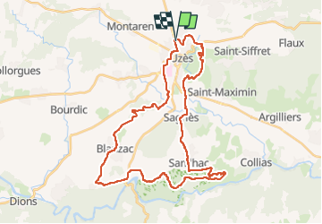
18 km | 23 km-effort
2h 0min
![](https://static1.geolcdn.com/siteimages/upload/files/16400158638029165_repeat_loop_refresh_sync_direction_icon.png)
Ja
![Tocht Stappen Saint-Siffret - au départ de St Siffrey - Photo](https://media.geolcdn.com/t/375/260/8522b7c1-bc14-4067-9a77-7eea509f42a2.jpg&format=jpg&maxdim=2)
![Stappen Stappen](https://static1.geolcdn.com/sitytour/trail-icons/101.png)
au départ de St Siffrey
Stappen
Medium
Saint-Siffret,
Occitanië,
Gard,
France
![](/images/other/stat-length.png)
18,2 km | 22 km-effort
5h 27min
![](https://static1.geolcdn.com/siteimages/upload/files/16400158638029165_repeat_loop_refresh_sync_direction_icon.png)
Ja
![Tocht Stappen Uzès - 2 Uzès par ch des amoureux Arpaillargues - Photo](https://media.geolcdn.com/t/375/260/ext.jpg?maxdim=2&url=https%3A%2F%2Fstatic1.geolcdn.com%2Fsiteimages%2Fupload%2Ffiles%2F1553511878bg_sport_marche.png)
![Stappen Stappen](https://static1.geolcdn.com/sitytour/trail-icons/101.png)
2 Uzès par ch des amoureux Arpaillargues
Stappen
Medium
(1)
Uzès,
Occitanië,
Gard,
France
![](/images/other/stat-length.png)
8 km | 10 km-effort
1h 51min
![](https://static1.geolcdn.com/siteimages/upload/files/16400158638029165_repeat_loop_refresh_sync_direction_icon.png)
Ja
![Tocht Stappen Serviers-et-Labaume - servers labame 2012 - Photo](https://media.geolcdn.com/t/375/260/ext.jpg?maxdim=2&url=https%3A%2F%2Fstatic1.geolcdn.com%2Fsiteimages%2Fupload%2Ffiles%2F1553511878bg_sport_marche.png)
![Stappen Stappen](https://static1.geolcdn.com/sitytour/trail-icons/101.png)
servers labame 2012
Stappen
Medium
(2)
Serviers-et-Labaume,
Occitanië,
Gard,
France
![](/images/other/stat-length.png)
13,8 km | 16,7 km-effort
1h 55min
![](https://static1.geolcdn.com/siteimages/upload/files/16400158638029165_repeat_loop_refresh_sync_direction_icon.png)
Ja
![Tocht Mountainbike Uzès - GARD VTT 2017 J3 - Photo](https://media.geolcdn.com/t/375/260/ext.jpg?maxdim=2&url=https%3A%2F%2Fstatic1.geolcdn.com%2Fsiteimages%2Fupload%2Ffiles%2F1524743154velo.jpg)
![Mountainbike Mountainbike](https://static1.geolcdn.com/sitytour/trail-icons/202.png)
GARD VTT 2017 J3
Mountainbike
Medium
(2)
Uzès,
Occitanië,
Gard,
France
![](/images/other/stat-length.png)
48 km | 60 km-effort
3h 53min
![](https://static1.geolcdn.com/siteimages/upload/files/16400158638029165_repeat_loop_refresh_sync_direction_icon.png)
Neen
![Tocht sport Uzès - Uzes wal de l Eure - Photo](https://media.geolcdn.com/t/375/260/d455ebd2-b704-4e2e-844e-f45e8f784ea6.jpg&format=jpg&maxdim=2)
Uzes wal de l Eure
sport
Heel gemakkelijk
Uzès,
Occitanië,
Gard,
France
![](/images/other/stat-length.png)
4,9 km | 6,2 km-effort
Onbekend
![](https://static1.geolcdn.com/siteimages/upload/files/16400158638029165_repeat_loop_refresh_sync_direction_icon.png)
Neen
![Tocht sport Uzès - Uzès 27/11/24 - Photo](https://media.geolcdn.com/t/375/260/95eef16a-03a7-487e-b925-502a31c18e3e.jpg&format=jpg&maxdim=2)
Uzès 27/11/24
sport
Heel gemakkelijk
Uzès,
Occitanië,
Gard,
France
![](/images/other/stat-length.png)
14,1 km | 17,1 km-effort
Onbekend
![](https://static1.geolcdn.com/siteimages/upload/files/16400158638029165_repeat_loop_refresh_sync_direction_icon.png)
Ja
![Tocht Stappen Serviers-et-Labaume - servers labame 2012 - Photo](https://media.geolcdn.com/t/375/260/ext.jpg?maxdim=2&url=https%3A%2F%2Fstatic1.geolcdn.com%2Fsiteimages%2Fupload%2Ffiles%2F1553511878bg_sport_marche.png)
![Stappen Stappen](https://static1.geolcdn.com/sitytour/trail-icons/101.png)
servers labame 2012
Stappen
Medium
(2)
Serviers-et-Labaume,
Occitanië,
Gard,
France
![](/images/other/stat-length.png)
7 km | 8,5 km-effort
1h 56min
![](https://static1.geolcdn.com/siteimages/upload/files/16400158638029165_repeat_loop_refresh_sync_direction_icon.png)
Ja
![Tocht Elektrische fiets Uzès - Balade au pont du Gard - Photo](https://media.geolcdn.com/t/375/260/c2cb8616-d79a-4486-980c-68d45ad416c4.jpg&format=jpg&maxdim=2)
![Elektrische fiets Elektrische fiets](https://static1.geolcdn.com/sitytour/trail-icons/205.png)
Balade au pont du Gard
Elektrische fiets
Gemakkelijk
Uzès,
Occitanië,
Gard,
France
![](/images/other/stat-length.png)
29 km | 33 km-effort
2h 30min
![](https://static1.geolcdn.com/siteimages/upload/files/16400158638029165_repeat_loop_refresh_sync_direction_icon.png)
Ja