![](/images/other/stat-length.png)
![Tocht Stappen Noisy-sur-École - Boucle 24 km Fontainebleau Arbonne - Photo](https://media.geolcdn.com/t/1900/400/5aaa62f0-dc57-4770-a77a-231413885a94.jpg&format=pjpeg&maxdim=2)
Boucle 24 km Fontainebleau Arbonne
chessyca
Gebruiker GUIDE
![Lengte](/images/other/stat-length.png)
Lengte
25 km
![Max. hoogte](https://static1.geolcdn.com/siteimages/upload/files/1508320355ic_sort_altitude_max_24dp.png)
Max. hoogte
126 m
![Positief hoogteverschil](https://static1.geolcdn.com/siteimages/upload/files/1508320355ic_sort_den_pos_24dp.png)
Positief hoogteverschil
427 m
![Km-Effort](/images/other/stat-length.png)
Km-Effort
31 km
![Min. hoogte](https://static1.geolcdn.com/siteimages/upload/files/1508320355ic_sort_altitude_min_24dp.png)
Min. hoogte
69 m
![Negatief hoogteverschil](https://static1.geolcdn.com/siteimages/upload/files/1508320355ic_sort_den_neg_24dp.png)
Negatief hoogteverschil
427 m
![Boucle](https://static1.geolcdn.com/siteimages/upload/files/16400158638029165_repeat_loop_refresh_sync_direction_icon.png)
Boucle
Ja
Datum van aanmaak :
2024-10-23 07:19:13.699
Laatste wijziging :
2024-10-23 18:38:46.758
![Stappen](https://static1.geolcdn.com/sitytour/trail-icons/101.png)
5h52
Moeilijkheid : Gemakkelijk
![Scan deze QR-code om de tocht te openen in de SityTrail-applicatie](https://capi.geolives.com/qq0zvz2zws4bq2lad0pu/sitytour/trails/4234491/qr.png?size=200)
Gratisgps-wandelapplicatie
Over ons
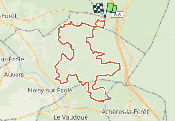
Tocht Stappen van 25 km beschikbaar op Île-de-France, Seine-et-Marne, Noisy-sur-École. Deze tocht wordt voorgesteld door chessyca.
Beschrijving
Boucle très variée menée par Félix.
Parcours Magnifique à la fois sportif par moment et pleins les yeux à d'autres
Plaatsbepaling
Land:
France
Regio :
Île-de-France
Departement/Provincie :
Seine-et-Marne
Gemeente :
Noisy-sur-École
Locatie:
Unknown
Vertrek:(Dec)
Vertrek:(UTM)
466436 ; 5361034 (31U) N.
Opmerkingen
Wandeltochten in de omgeving
![Tocht Stappen Barbizon - Sentier des peintres - Photo](https://media.geolcdn.com/t/375/260/ext.jpg?maxdim=2&url=https%3A%2F%2Fservices.sitytrail.com%2FGeolivesWS%2FDownloadMedia.ashx%3FTrailID%3D188736%26Media%3D187396bd-9ee4-4169-9310-5793d2588587.jpeg)
![Stappen Stappen](https://static1.geolcdn.com/sitytour/trail-icons/101.png)
Sentier des peintres
Stappen
Medium
(11)
Barbizon,
Île-de-France,
Seine-et-Marne,
France
![](/images/other/stat-length.png)
7,5 km | 8,2 km-effort
1h 25min
![](https://static1.geolcdn.com/siteimages/upload/files/16400158638029165_repeat_loop_refresh_sync_direction_icon.png)
Ja
![Tocht Stappen Le Vaudoué - Ultra 25 bosses - Photo](https://media.geolcdn.com/t/375/260/ext.jpg?maxdim=2&url=https%3A%2F%2Fservices.sitytrail.com%2FGeolivesWS%2FDownloadMedia.ashx%3FTrailID%3D243413%26Media%3Dfix__20140112104549.jpg)
![Stappen Stappen](https://static1.geolcdn.com/sitytour/trail-icons/101.png)
Ultra 25 bosses
Stappen
Moeilijk
(1)
Le Vaudoué,
Île-de-France,
Seine-et-Marne,
France
![](/images/other/stat-length.png)
25 km | 32 km-effort
9h 2min
![](https://static1.geolcdn.com/siteimages/upload/files/16400158638029165_repeat_loop_refresh_sync_direction_icon.png)
Ja
![Tocht Stappen Noisy-sur-École - M&R-121118 - 250Marches - Photo](https://media.geolcdn.com/t/375/260/ext.jpg?maxdim=2&url=https%3A%2F%2Fservices.sitytrail.com%2FGeolivesWS%2FDownloadMedia.ashx%3FTrailID%3D163348%26Media%3D20121118101634.jpeg)
![Stappen Stappen](https://static1.geolcdn.com/sitytour/trail-icons/101.png)
M&R-121118 - 250Marches
Stappen
Gemakkelijk
(1)
Noisy-sur-École,
Île-de-France,
Seine-et-Marne,
France
![](/images/other/stat-length.png)
14,3 km | 18,1 km-effort
3h 50min
![](https://static1.geolcdn.com/siteimages/upload/files/16400158638029165_repeat_loop_refresh_sync_direction_icon.png)
Ja
![Tocht Stappen Milly-la-Forêt - Du parking de la Boulignère aux 100 marches via la ferme des Coquibus - Photo](https://media.geolcdn.com/t/375/260/2d4021ff-70a8-48ff-ad65-d6df60ccba59.jpg&format=jpg&maxdim=2)
![Stappen Stappen](https://static1.geolcdn.com/sitytour/trail-icons/101.png)
Du parking de la Boulignère aux 100 marches via la ferme des Coquibus
Stappen
Moeilijk
(1)
Milly-la-Forêt,
Île-de-France,
Essonne,
France
![](/images/other/stat-length.png)
18,3 km | 22 km-effort
5h 0min
![](https://static1.geolcdn.com/siteimages/upload/files/16400158638029165_repeat_loop_refresh_sync_direction_icon.png)
Ja
![Tocht Stappen Noisy-sur-École - Bois Rond#4 - Photo](https://media.geolcdn.com/t/375/260/7321184d-880d-445f-98b4-47f0ff0d82dd.jpg&format=jpg&maxdim=2)
![Stappen Stappen](https://static1.geolcdn.com/sitytour/trail-icons/101.png)
Bois Rond#4
Stappen
Heel gemakkelijk
(1)
Noisy-sur-École,
Île-de-France,
Seine-et-Marne,
France
![](/images/other/stat-length.png)
8,8 km | 10,5 km-effort
2h 18min
![](https://static1.geolcdn.com/siteimages/upload/files/16400158638029165_repeat_loop_refresh_sync_direction_icon.png)
Ja
![Tocht Stappen Noisy-sur-École - Les 25 Bosses - Gps en Forêt de Fontainebleau - Photo](https://media.geolcdn.com/t/375/260/ext.jpg?maxdim=2&url=https%3A%2F%2Fservices.sitytrail.com%2FGeolivesWS%2FDownloadMedia.ashx%3FTrailID%3D101528%26Media%3D1630_1.jpg)
![Stappen Stappen](https://static1.geolcdn.com/sitytour/trail-icons/101.png)
Les 25 Bosses - Gps en Forêt de Fontainebleau
Stappen
Zeer moeilijk
(2)
Noisy-sur-École,
Île-de-France,
Seine-et-Marne,
France
![](/images/other/stat-length.png)
17,6 km | 23 km-effort
4h 45min
![](https://static1.geolcdn.com/siteimages/upload/files/16400158638029165_repeat_loop_refresh_sync_direction_icon.png)
Ja
![Tocht Te voet Milly-la-Forêt - Boucle 16 km Coquibus - Platières - Photo](https://media.geolcdn.com/t/375/260/6a2a1ae6-ffd2-44a3-8670-01d58b5995c6.jpg&format=jpg&maxdim=2)
![Te voet Te voet](https://static1.geolcdn.com/sitytour/trail-icons/100.png)
Boucle 16 km Coquibus - Platières
Te voet
Gemakkelijk
Milly-la-Forêt,
Île-de-France,
Essonne,
France
![](/images/other/stat-length.png)
16,2 km | 19,4 km-effort
4h 24min
![](https://static1.geolcdn.com/siteimages/upload/files/16400158638029165_repeat_loop_refresh_sync_direction_icon.png)
Ja
![Tocht Stappen Fontainebleau - Boucle Barbizon - Arbonne 26 km - Photo](https://media.geolcdn.com/t/375/260/d3a133ff-ea77-47a6-826a-54bbe45391c4.jpg&format=jpg&maxdim=2)
![Stappen Stappen](https://static1.geolcdn.com/sitytour/trail-icons/101.png)
Boucle Barbizon - Arbonne 26 km
Stappen
Medium
Fontainebleau,
Île-de-France,
Seine-et-Marne,
France
![](/images/other/stat-length.png)
26 km | 30 km-effort
5h 6min
![](https://static1.geolcdn.com/siteimages/upload/files/16400158638029165_repeat_loop_refresh_sync_direction_icon.png)
Ja
![Tocht Te voet Le Vaudoué - Boucle Le Vaudoué - Photo](https://media.geolcdn.com/t/375/260/d05a3ec5-b137-48e5-a689-019375766e60.jpg&format=jpg&maxdim=2)
![Te voet Te voet](https://static1.geolcdn.com/sitytour/trail-icons/100.png)
Boucle Le Vaudoué
Te voet
Medium
Le Vaudoué,
Île-de-France,
Seine-et-Marne,
France
![](/images/other/stat-length.png)
17,4 km | 21 km-effort
4h 47min
![](https://static1.geolcdn.com/siteimages/upload/files/16400158638029165_repeat_loop_refresh_sync_direction_icon.png)
Ja