![](/images/other/stat-length.png)
![Tocht Stappen Saint-Denis-le-Thiboult - Ry - départ La Rémondière - PT - Photo](https://media.geolcdn.com/t/1900/400/ext.pjpeg?maxdim=2&url=https%3A%2F%2Fstatic1.geolcdn.com%2Fsiteimages%2Fupload%2Ffiles%2F1553511878bg_sport_marche.png)
Ry - départ La Rémondière - PT
philippe76
Gebruiker
![Lengte](/images/other/stat-length.png)
Lengte
7 km
![Max. hoogte](https://static1.geolcdn.com/siteimages/upload/files/1508320355ic_sort_altitude_max_24dp.png)
Max. hoogte
159 m
![Positief hoogteverschil](https://static1.geolcdn.com/siteimages/upload/files/1508320355ic_sort_den_pos_24dp.png)
Positief hoogteverschil
106 m
![Km-Effort](/images/other/stat-length.png)
Km-Effort
8,6 km
![Min. hoogte](https://static1.geolcdn.com/siteimages/upload/files/1508320355ic_sort_altitude_min_24dp.png)
Min. hoogte
66 m
![Negatief hoogteverschil](https://static1.geolcdn.com/siteimages/upload/files/1508320355ic_sort_den_neg_24dp.png)
Negatief hoogteverschil
177 m
![Boucle](https://static1.geolcdn.com/siteimages/upload/files/16400158638029165_repeat_loop_refresh_sync_direction_icon.png)
Boucle
Neen
Datum van aanmaak :
2024-10-22 15:35:55.803
Laatste wijziging :
2024-10-22 15:43:38.964
![Stappen](https://static1.geolcdn.com/sitytour/trail-icons/101.png)
1h57
Moeilijkheid : Medium
![Scan deze QR-code om de tocht te openen in de SityTrail-applicatie](https://capi.geolives.com/qq0zvz2zws4bq2lad0pu/sitytour/trails/4233508/qr.png?size=200)
Gratisgps-wandelapplicatie
Over ons
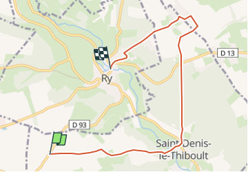
Tocht Stappen van 7 km beschikbaar op Normandië, Seine-Maritime, Saint-Denis-le-Thiboult. Deze tocht wordt voorgesteld door philippe76.
Beschrijving
Départ sur la D93, au lieu dit La Rémondière. Descendre vers St-Denis-Le-Thiboult, remonter vers Les Ventes, puis Le Puits et redescendre vers RY. Arrivée à l' ex office de Tourisme.
Plaatsbepaling
Land:
France
Regio :
Normandië
Departement/Provincie :
Seine-Maritime
Gemeente :
Saint-Denis-le-Thiboult
Locatie:
Unknown
Vertrek:(Dec)
Vertrek:(UTM)
378914 ; 5479796 (31U) N.
Opmerkingen
Wandeltochten in de omgeving
![Tocht Stappen Bois-l'Évêque - Bois-L'Evêque - Martainville - PT - Photo](https://media.geolcdn.com/t/375/260/ext.jpg?maxdim=2&url=https%3A%2F%2Fstatic1.geolcdn.com%2Fsiteimages%2Fupload%2Ffiles%2F1553511878bg_sport_marche.png)
![Stappen Stappen](https://static1.geolcdn.com/sitytour/trail-icons/101.png)
Bois-L'Evêque - Martainville - PT
Stappen
Medium
(1)
Bois-l'Évêque,
Normandië,
Seine-Maritime,
France
![](/images/other/stat-length.png)
7,1 km | 7,6 km-effort
1h 43min
![](https://static1.geolcdn.com/siteimages/upload/files/16400158638029165_repeat_loop_refresh_sync_direction_icon.png)
Neen
![Tocht Stappen Ry - 20180717 Ry - Photo](https://media.geolcdn.com/t/375/260/b30395c9-0797-4cee-b9f6-edfda2e59801.jpg&format=jpg&maxdim=2)
![Stappen Stappen](https://static1.geolcdn.com/sitytour/trail-icons/101.png)
20180717 Ry
Stappen
Medium
(1)
Ry,
Normandië,
Seine-Maritime,
France
![](/images/other/stat-length.png)
12,3 km | 0 m-effort
3h 22min
![](https://static1.geolcdn.com/siteimages/upload/files/16400158638029165_repeat_loop_refresh_sync_direction_icon.png)
Ja
![Tocht Stappen Le Héron - Rebets par l'Héronchelles - Photo](https://media.geolcdn.com/t/375/260/d3f3818d-0528-4506-9a5b-801bed775619.jpg&format=jpg&maxdim=2)
![Stappen Stappen](https://static1.geolcdn.com/sitytour/trail-icons/101.png)
Rebets par l'Héronchelles
Stappen
Moeilijk
Le Héron,
Normandië,
Seine-Maritime,
France
![](/images/other/stat-length.png)
11,2 km | 15,2 km-effort
3h 7min
![](https://static1.geolcdn.com/siteimages/upload/files/16400158638029165_repeat_loop_refresh_sync_direction_icon.png)
Ja
![Stappen Stappen](https://static1.geolcdn.com/sitytour/trail-icons/101.png)
20231207-Vascoeuil
Stappen
Medium
Vascœuil,
Normandië,
Eure,
France
![](/images/other/stat-length.png)
10,9 km | 14,1 km-effort
3h 6min
![](https://static1.geolcdn.com/siteimages/upload/files/16400158638029165_repeat_loop_refresh_sync_direction_icon.png)
Ja
![Stappen Stappen](https://static1.geolcdn.com/sitytour/trail-icons/101.png)
20230926-St Aignan sur Ry
Stappen
Medium
Saint-Aignan-sur-Ry,
Normandië,
Seine-Maritime,
France
![](/images/other/stat-length.png)
11,8 km | 15,6 km-effort
3h 23min
![](https://static1.geolcdn.com/siteimages/upload/files/16400158638029165_repeat_loop_refresh_sync_direction_icon.png)
Ja
![Stappen Stappen](https://static1.geolcdn.com/sitytour/trail-icons/101.png)
20230314-Auzouville sur Ry
Stappen
Medium
Auzouville-sur-Ry,
Normandië,
Seine-Maritime,
France
![](/images/other/stat-length.png)
13,2 km | 15,6 km-effort
3h 14min
![](https://static1.geolcdn.com/siteimages/upload/files/16400158638029165_repeat_loop_refresh_sync_direction_icon.png)
Ja
![Stappen Stappen](https://static1.geolcdn.com/sitytour/trail-icons/101.png)
20220426-Ry
Stappen
Medium
Ry,
Normandië,
Seine-Maritime,
France
![](/images/other/stat-length.png)
11,7 km | 14,6 km-effort
3h 8min
![](https://static1.geolcdn.com/siteimages/upload/files/16400158638029165_repeat_loop_refresh_sync_direction_icon.png)
Ja
![Stappen Stappen](https://static1.geolcdn.com/sitytour/trail-icons/101.png)
20220222-Auzouville sur Ry
Stappen
Medium
Auzouville-sur-Ry,
Normandië,
Seine-Maritime,
France
![](/images/other/stat-length.png)
13,3 km | 15,6 km-effort
3h 27min
![](https://static1.geolcdn.com/siteimages/upload/files/16400158638029165_repeat_loop_refresh_sync_direction_icon.png)
Ja
![Tocht Stappen Martainville-Épreville - martainville - Photo](https://media.geolcdn.com/t/375/260/ext.jpg?maxdim=2&url=https%3A%2F%2Fstatic1.geolcdn.com%2Fsiteimages%2Fupload%2Ffiles%2F1553511878bg_sport_marche.png)
![Stappen Stappen](https://static1.geolcdn.com/sitytour/trail-icons/101.png)
martainville
Stappen
Heel gemakkelijk
(1)
Martainville-Épreville,
Normandië,
Seine-Maritime,
France
![](/images/other/stat-length.png)
13 km | 14,3 km-effort
3h 4min
![](https://static1.geolcdn.com/siteimages/upload/files/16400158638029165_repeat_loop_refresh_sync_direction_icon.png)
Ja