![](/images/other/stat-length.png)
![Tocht Stappen Saint-Cyr-sur-Loire - Saint-Cyr-sur-Loire la Gagnerie - la Membrolle-sur-Choisille Mettray - 24km 405m 5h15 (50mn) - 2024 10 20 - Photo](https://media.geolcdn.com/t/1900/400/21cd2b46-14f0-4eaa-a3c8-0e5f8e58cc4a.jpg&format=pjpeg&maxdim=2)
Saint-Cyr-sur-Loire la Gagnerie - la Membrolle-sur-Choisille Mettray - 24km 405m 5h15 (50mn) - 2024 10 20
Orcal37
Gebruiker GUIDE
![Lengte](/images/other/stat-length.png)
Lengte
24 km
![Max. hoogte](https://static1.geolcdn.com/siteimages/upload/files/1508320355ic_sort_altitude_max_24dp.png)
Max. hoogte
101 m
![Positief hoogteverschil](https://static1.geolcdn.com/siteimages/upload/files/1508320355ic_sort_den_pos_24dp.png)
Positief hoogteverschil
407 m
![Km-Effort](/images/other/stat-length.png)
Km-Effort
29 km
![Min. hoogte](https://static1.geolcdn.com/siteimages/upload/files/1508320355ic_sort_altitude_min_24dp.png)
Min. hoogte
53 m
![Negatief hoogteverschil](https://static1.geolcdn.com/siteimages/upload/files/1508320355ic_sort_den_neg_24dp.png)
Negatief hoogteverschil
405 m
![Boucle](https://static1.geolcdn.com/siteimages/upload/files/16400158638029165_repeat_loop_refresh_sync_direction_icon.png)
Boucle
Ja
Datum van aanmaak :
2024-10-20 09:06:50.733
Laatste wijziging :
2024-10-20 18:06:26.803
![Stappen](https://static1.geolcdn.com/sitytour/trail-icons/101.png)
5h15
Moeilijkheid : Medium
![Scan deze QR-code om de tocht te openen in de SityTrail-applicatie](https://capi.geolives.com/qq0zvz2zws4bq2lad0pu/sitytour/trails/4231335/qr.png?size=200)
Gratisgps-wandelapplicatie
Over ons
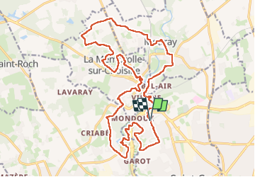
Tocht Stappen van 24 km beschikbaar op Centre-Val de Loire, Indre-et-Loire, Saint-Cyr-sur-Loire. Deze tocht wordt voorgesteld door Orcal37.
Beschrijving
Saint-Cyr-sur-Loire la Gagnerie - la Membrolle-sur-Choisille - Mettray - 24km 405m 5h15 (50mn) - 2024 10 20
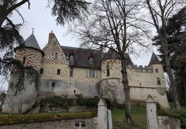
Plaatsbepaling
Land:
France
Regio :
Centre-Val de Loire
Departement/Provincie :
Indre-et-Loire
Gemeente :
Saint-Cyr-sur-Loire
Locatie:
Unknown
Vertrek:(Dec)
Vertrek:(UTM)
322379 ; 5255251 (31T) N.
Opmerkingen
Wandeltochten in de omgeving
![Tocht Stappen Fondettes - Fondettes Vallières - Luynes Le Vieux-Bourg - 26.1km 360m 5h30 (45mn) - 2024 12 11 - Photo](https://media.geolcdn.com/t/375/260/7ea9ad8d-3a09-4814-97d4-258e1355629e.jpg&format=jpg&maxdim=2)
![Stappen Stappen](https://static1.geolcdn.com/sitytour/trail-icons/101.png)
Fondettes Vallières - Luynes Le Vieux-Bourg - 26.1km 360m 5h30 (45mn) - 2024 ...
Stappen
Medium
Fondettes,
Centre-Val de Loire,
Indre-et-Loire,
France
![](/images/other/stat-length.png)
26 km | 31 km-effort
5h 30min
![](https://static1.geolcdn.com/siteimages/upload/files/16400158638029165_repeat_loop_refresh_sync_direction_icon.png)
Ja
![Tocht Stappen Fondettes - Fondettes Gare - Saint-Cyr-sur-Loire Tours - 23.4km 345m 5h10 (40mn) - 2024 10 27 - Photo](https://media.geolcdn.com/t/375/260/8177205d-60d4-4a9b-baf6-cca40bb2f1c5.jpg&format=jpg&maxdim=2)
![Stappen Stappen](https://static1.geolcdn.com/sitytour/trail-icons/101.png)
Fondettes Gare - Saint-Cyr-sur-Loire Tours - 23.4km 345m 5h10 (40mn) - 2024 1...
Stappen
Gemakkelijk
Fondettes,
Centre-Val de Loire,
Indre-et-Loire,
France
![](/images/other/stat-length.png)
23 km | 28 km-effort
5h 10min
![](https://static1.geolcdn.com/siteimages/upload/files/16400158638029165_repeat_loop_refresh_sync_direction_icon.png)
Ja
![Tocht Stappen Fondettes - Fondettes Charcenay - Sentier Val de Choisille avec variantes - 23.5km 335m 5h10 (55mn) - 2024 10 13 - Photo](https://media.geolcdn.com/t/375/260/da5cdfb1-5871-4878-b704-e11c5bcbf000.jpg&format=jpg&maxdim=2)
![Stappen Stappen](https://static1.geolcdn.com/sitytour/trail-icons/101.png)
Fondettes Charcenay - Sentier Val de Choisille avec variantes - 23.5km 335m 5...
Stappen
Gemakkelijk
Fondettes,
Centre-Val de Loire,
Indre-et-Loire,
France
![](/images/other/stat-length.png)
23 km | 28 km-effort
5h 10min
![](https://static1.geolcdn.com/siteimages/upload/files/16400158638029165_repeat_loop_refresh_sync_direction_icon.png)
Ja
![Tocht Stappen Saint-Pierre-des-Corps - Saint-Pierre-des-Corps - PR Sentier du bord de Loire avec variantes - 13.6km 75m 2h55 (30mn) - 2023 10 22 - Photo](https://media.geolcdn.com/t/375/260/6a165834-3cba-4860-930a-9c6f29b052c7.jpg&format=jpg&maxdim=2)
![Stappen Stappen](https://static1.geolcdn.com/sitytour/trail-icons/101.png)
Saint-Pierre-des-Corps - PR Sentier du bord de Loire avec variantes - 13.6km ...
Stappen
Gemakkelijk
Saint-Pierre-des-Corps,
Centre-Val de Loire,
Indre-et-Loire,
France
![](/images/other/stat-length.png)
13,6 km | 14,7 km-effort
2h 55min
![](https://static1.geolcdn.com/siteimages/upload/files/16400158638029165_repeat_loop_refresh_sync_direction_icon.png)
Ja
![Tocht Stappen Tours (Indre-et-Loire) - Tours - Bd Béranger La Riche - 8.8km 45m 2h00 - 2022 09 12 - Photo](https://media.geolcdn.com/t/375/260/42e96b35-6e0b-4b51-82b8-ef6cff621515.jpg&format=jpg&maxdim=2)
![Stappen Stappen](https://static1.geolcdn.com/sitytour/trail-icons/101.png)
Tours - Bd Béranger La Riche - 8.8km 45m 2h00 - 2022 09 12
Stappen
Heel gemakkelijk
Tours (Indre-et-Loire),
Centre-Val de Loire,
Indre-et-Loire,
France
![](/images/other/stat-length.png)
8,8 km | 9,4 km-effort
2h 0min
![](https://static1.geolcdn.com/siteimages/upload/files/16400158638029165_repeat_loop_refresh_sync_direction_icon.png)
Ja
![Tocht Stappen Fondettes - Fondettes - Impro 4 communes - 21.6km 200m 4h40 (30mn) - 2021 04 24 - Photo](https://media.geolcdn.com/t/375/260/8360f715-226c-4f82-afa7-992b48458f8c.jpg&format=jpg&maxdim=2)
![Stappen Stappen](https://static1.geolcdn.com/sitytour/trail-icons/101.png)
Fondettes - Impro 4 communes - 21.6km 200m 4h40 (30mn) - 2021 04 24
Stappen
Gemakkelijk
Fondettes,
Centre-Val de Loire,
Indre-et-Loire,
France
![](/images/other/stat-length.png)
22 km | 24 km-effort
4h 40min
![](https://static1.geolcdn.com/siteimages/upload/files/16400158638029165_repeat_loop_refresh_sync_direction_icon.png)
Ja
![Tocht Stappen Charentilly - Charentilly - Circuit 2 avec variante - 14.8km 135m 3h05 - 2020 08 15 - Photo](https://media.geolcdn.com/t/375/260/3d2c51a1-3af7-44d8-bc0c-6a33566d6f6e.jpg&format=jpg&maxdim=2)
![Stappen Stappen](https://static1.geolcdn.com/sitytour/trail-icons/101.png)
Charentilly - Circuit 2 avec variante - 14.8km 135m 3h05 - 2020 08 15
Stappen
Gemakkelijk
Charentilly,
Centre-Val de Loire,
Indre-et-Loire,
France
![](/images/other/stat-length.png)
14,8 km | 16,6 km-effort
3h 5min
![](https://static1.geolcdn.com/siteimages/upload/files/16400158638029165_repeat_loop_refresh_sync_direction_icon.png)
Ja
![Tocht Stappen Mettray - Mettray - Dolmen - 12.9km 160m 2h40 - 2020 07 26 - Photo](https://media.geolcdn.com/t/375/260/7eb82ac0-48df-4237-a483-c208fe4e7abd.jpg&format=jpg&maxdim=2)
![Stappen Stappen](https://static1.geolcdn.com/sitytour/trail-icons/101.png)
Mettray - Dolmen - 12.9km 160m 2h40 - 2020 07 26
Stappen
Gemakkelijk
Mettray,
Centre-Val de Loire,
Indre-et-Loire,
France
![](/images/other/stat-length.png)
12,9 km | 15 km-effort
2h 40min
![](https://static1.geolcdn.com/siteimages/upload/files/16400158638029165_repeat_loop_refresh_sync_direction_icon.png)
Ja
![Tocht Stappen La Membrolle-sur-Choisille - La Membrolle-sur-Choisille - sentier Petite Choisille - 11.9km 170m 2h30 - 2020 07 24 - Photo](https://media.geolcdn.com/t/375/260/f6ef86c8-3755-4875-9651-44b6a31fd08c.jpg&format=jpg&maxdim=2)
![Stappen Stappen](https://static1.geolcdn.com/sitytour/trail-icons/101.png)
La Membrolle-sur-Choisille - sentier Petite Choisille - 11.9km 170m 2h30 - 20...
Stappen
Gemakkelijk
La Membrolle-sur-Choisille,
Centre-Val de Loire,
Indre-et-Loire,
France
![](/images/other/stat-length.png)
11,9 km | 14,2 km-effort
2h 30min
![](https://static1.geolcdn.com/siteimages/upload/files/16400158638029165_repeat_loop_refresh_sync_direction_icon.png)
Ja