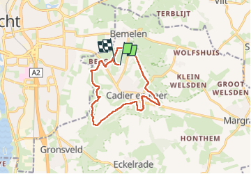
![](/images/other/stat-length.png)
![Tocht Stappen Eijsden-Margraten - Cadier en Keer - Photo](https://media.geolcdn.com/t/1900/400/12241d80-2d73-4835-9b39-cb26df63df20.jpg&format=pjpeg&maxdim=2)
Cadier en Keer
Je vous emmène sur mes chemins
Par Mumu.larandonneuse
![Lengte](/images/other/stat-length.png)
![Max. hoogte](https://static1.geolcdn.com/siteimages/upload/files/1508320355ic_sort_altitude_max_24dp.png)
![Positief hoogteverschil](https://static1.geolcdn.com/siteimages/upload/files/1508320355ic_sort_den_pos_24dp.png)
![Km-Effort](/images/other/stat-length.png)
![Min. hoogte](https://static1.geolcdn.com/siteimages/upload/files/1508320355ic_sort_altitude_min_24dp.png)
![Negatief hoogteverschil](https://static1.geolcdn.com/siteimages/upload/files/1508320355ic_sort_den_neg_24dp.png)
![Boucle](https://static1.geolcdn.com/siteimages/upload/files/16400158638029165_repeat_loop_refresh_sync_direction_icon.png)
![Stappen](https://static1.geolcdn.com/sitytour/trail-icons/101.png)
2h38
Moeilijkheid : Gemakkelijk
![Scan deze QR-code om de tocht te openen in de SityTrail-applicatie](https://capi.geolives.com/qq0zvz2zws4bq2lad0pu/sitytour/trails/4216557/qr.png?size=200)
Gratisgps-wandelapplicatie
Over ons
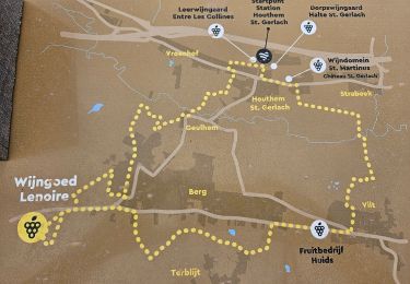
Tocht Stappen van 11,2 km beschikbaar op Limburg, Onbekend, Eijsden-Margraten. Deze tocht wordt voorgesteld door Je vous emmène sur mes chemins .
Beschrijving
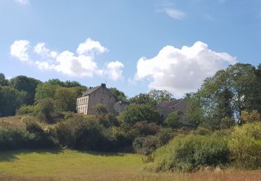
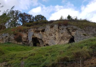
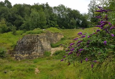
🇳🇱 Une splendide randonnée autour de Cadier en Keer sur les chemins boisés et les sentiers campagnards.
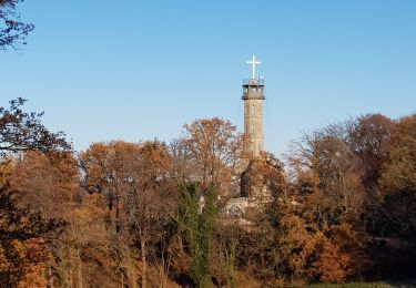
👀 Le Heerderberg offre de magnifiques panoramas sur Maastricht et ses alentours (Montagne St Pierre, vallée de la Meuse, ...)
ℹ️ Gpx, plan et descriptif sur www.wandelgidszuidlimburg.com n° 373
Plaatsbepaling
Opmerkingen
Wandeltochten in de omgeving
![Tocht Stappen Eijsden-Margraten - 2024-01-08_03h28m34_eijsden-margraten-e8-bloesemroute-3 - Photo](https://media.geolcdn.com/t/375/260/7792b7db-95a9-4b53-8cd5-7eae3fedc6a4.jpg&format=jpg&maxdim=2)
![Stappen Stappen](https://static1.geolcdn.com/sitytour/trail-icons/101.png)
Stappen
![](/images/other/stat-length.png)
![](https://static1.geolcdn.com/siteimages/upload/files/16400158638029165_repeat_loop_refresh_sync_direction_icon.png)
![Tocht Stappen Valkenburg aan de Geul - 2023-08-29_11h45m24_route-des-vins-berg-en-terblijt--houthem-st-gerlach-vi6 - Photo](https://media.geolcdn.com/t/375/260/852c106e-818c-4548-acc4-e956e65bf915.jpg&format=jpg&maxdim=2)
![Stappen Stappen](https://static1.geolcdn.com/sitytour/trail-icons/101.png)
Stappen
![](/images/other/stat-length.png)
![](https://static1.geolcdn.com/siteimages/upload/files/16400158638029165_repeat_loop_refresh_sync_direction_icon.png)
![Tocht Stappen Maastricht - 2023-07-28_14h10m13_1693.gpx.xml - Photo](https://media.geolcdn.com/t/375/260/35d0d485-5909-42ec-b3f4-9d96e17c2c7d.jpg&format=jpg&maxdim=2)
![Stappen Stappen](https://static1.geolcdn.com/sitytour/trail-icons/101.png)
Stappen
![](/images/other/stat-length.png)
![](https://static1.geolcdn.com/siteimages/upload/files/16400158638029165_repeat_loop_refresh_sync_direction_icon.png)
![Tocht Stappen Valkenburg aan de Geul - Sibbe - Valkenburg 🎄🎅 - Photo](https://media.geolcdn.com/t/375/260/635f6fea-be0e-416f-bbe0-3fc5facaae54.jpg&format=jpg&maxdim=2)
![Stappen Stappen](https://static1.geolcdn.com/sitytour/trail-icons/101.png)
Stappen
![](/images/other/stat-length.png)
![](https://static1.geolcdn.com/siteimages/upload/files/16400158638029165_repeat_loop_refresh_sync_direction_icon.png)
![Tocht Stappen Eijsden-Margraten - 2022-11-10_16h33m33_1327 - Photo](https://media.geolcdn.com/t/375/260/877eed2d-204c-4212-a49e-caf4fc574b56.jpg&format=jpg&maxdim=2)
![Stappen Stappen](https://static1.geolcdn.com/sitytour/trail-icons/101.png)
Stappen
![](/images/other/stat-length.png)
![](https://static1.geolcdn.com/siteimages/upload/files/16400158638029165_repeat_loop_refresh_sync_direction_icon.png)
![Tocht Stappen Maastricht - Maastricht - Hoge Fronten & 't Bassin - Photo](https://media.geolcdn.com/t/375/260/0d1db1de-c9bf-433a-9df4-c07031a55999.jpg&format=jpg&maxdim=2)
![Stappen Stappen](https://static1.geolcdn.com/sitytour/trail-icons/101.png)
Stappen
![](/images/other/stat-length.png)
![](https://static1.geolcdn.com/siteimages/upload/files/16400158638029165_repeat_loop_refresh_sync_direction_icon.png)
![Tocht Stappen Maastricht - 2022-07-06_09h30m07_1540 - Photo](https://media.geolcdn.com/t/375/260/8e415027-26b4-4bc6-9623-75f03f38b59c.jpg&format=jpg&maxdim=2)
![Stappen Stappen](https://static1.geolcdn.com/sitytour/trail-icons/101.png)
Stappen
![](/images/other/stat-length.png)
![](https://static1.geolcdn.com/siteimages/upload/files/16400158638029165_repeat_loop_refresh_sync_direction_icon.png)
![Tocht Stappen Maastricht - 2021-10-27_21h23m34_1087 - Photo](https://media.geolcdn.com/t/375/260/23f3cb69-ec7d-4156-85e2-e9b9420f412b.jpg&format=jpg&maxdim=2)
![Stappen Stappen](https://static1.geolcdn.com/sitytour/trail-icons/101.png)
Stappen
![](/images/other/stat-length.png)
![](https://static1.geolcdn.com/siteimages/upload/files/16400158638029165_repeat_loop_refresh_sync_direction_icon.png)
![Tocht Stappen Valkenburg aan de Geul - 2021-07-31_16h24m37_668 (1) - Photo](https://media.geolcdn.com/t/375/260/068441ca-100f-4e0b-aeb5-ac0dbbad0b2b.jpg&format=jpg&maxdim=2)
![Stappen Stappen](https://static1.geolcdn.com/sitytour/trail-icons/101.png)
Stappen
![](/images/other/stat-length.png)
![](https://static1.geolcdn.com/siteimages/upload/files/16400158638029165_repeat_loop_refresh_sync_direction_icon.png)