Tocht  Levroux - Sob 14 bis moulins buzancais  - Photo

Sob 14 bis moulins buzancais

 Glurps
Glurps

Gebruiker

© OpenStreetMap contributors
Lengte
Lengte
17,6 km
Max. hoogte
Max. hoogte
159 m
Positief hoogteverschil
83 m
Km-Effort
Km-Effort  
18,9 km
Min. hoogte
Min. hoogte
106 m
Negatief hoogteverschil
133 m
Boucle
Boucle
Neen
Datum van aanmaak :
2024-09-23 08:39:51.0
Laatste wijziging :
2024-09-23 14:28:27.505

(0 Bericht)


Scan deze QR-code om de tocht te openen in de SityTrail-applicatie

Gratisgps-wandelapplicatie

Logo SityTrail SityTrail

IGN / Geografische instituten

SityTrail uit de App Store downloaden SityTrail uit Google Play downloaden

Logo SityTrail SityTrail World

De wereld gaat voor u open

SityTrail uit de App Store downloaden SityTrail uit Google Play downloaden SityTrail op Huawei AppGallery downloaden

Over ons

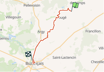
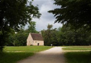
Tocht van 17,6 km beschikbaar op Centre-Val de Loire, Indre, Levroux. Deze tocht wordt voorgesteld door Glurps.

Hoogteprofiel

Plaatsbepaling

Land:
France
Regio :
Centre-Val de Loire
Departement/Provincie :
Indre
Gemeente :
Levroux
Locatie:
Saint-Pierre-de-Lamps
Vertrek:(Dec)
Vertrek:(UTM)
386717 ; 5203287 (31T) N.

Wandeltochten in de omgeving

Tocht Lopen Châteauroux - sortie 1er de l'an - Photo
Lopen
will36

Lopen

Gemakkelijk
(1)
Châteauroux, Centre-Val de Loire, Indre, France
10,3 km | 11,4 km-effort
58min
Ja
Tocht Fiets Mézières-en-Brenne - J4 Le Cormier - Photo
Fiets
cn29122

Fiets

Medium
(1)
Mézières-en-Brenne, Centre-Val de Loire, Indre, France
29 km | 32 km-effort
1h 51min
Neen
Tocht Fiets Mézières-en-Brenne - 1707 Brenne N°4 - Photo
Fiets
benyou

Fiets

Gemakkelijk
Mézières-en-Brenne, Centre-Val de Loire, Indre, France
27 km | 28 km-effort
2h 24min
Ja
Tocht Mountainbike Mézières-en-Brenne - 1707_Brenne N°4 - Photo
Mountainbike
benyou

Mountainbike

Gemakkelijk
Mézières-en-Brenne, Centre-Val de Loire, Indre, France
27 km | 28 km-effort
2h 24min
Ja
Tocht sport Buzançais - Sob 15 buzancais bellebouche - Photo
sport
Glurps

sport

Heel gemakkelijk
Buzançais, Centre-Val de Loire, Indre, France
25 km | 27 km-effort
Onbekend
Neen
Tocht Stappen Vicq-sur-Nahon - Viocq , Valancey  - Photo
Stappen
2433e59

Stappen

Heel gemakkelijk
Vicq-sur-Nahon, Centre-Val de Loire, Indre, France
12,5 km | 14,4 km-effort
3h 19min
Neen
Tocht Stappen Luçay-le-Mâle - La Foulquetière - Le Puits de Saray - Photo
Stappen
annehc

Stappen

Zeer moeilijk
Luçay-le-Mâle, Centre-Val de Loire, Indre, France
25 km | 28 km-effort
5h 15min
Neen
Tocht Te voet Gehée - Randonnée - boucle jaune - Géhée - Photo
Te voet
Fredrando64

Te voet

Gemakkelijk
Gehée, Centre-Val de Loire, Indre, France
10,5 km | 12,1 km-effort
2h 45min
Ja
Tocht Te voet Vendœuvres - La forêt de Lancosme - Photo
Te voet
Phil36

Te voet

Moeilijk
Vendœuvres, Centre-Val de Loire, Indre, France
22 km | 24 km-effort
5h 30min
Ja


Sluiten
Mijn abonnementen