![](/images/other/stat-length.png)
![Tocht Stappen Niederhaslach - Niederhaslach - châteaux Ringelstein - Rochers du Pfaffenlapp et du Breitberg - Photo](https://media.geolcdn.com/t/1900/400/c0bf6ddc-3734-4e1a-8eee-66925b0d6d19.jpg&format=pjpeg&maxdim=2)
Niederhaslach - châteaux Ringelstein - Rochers du Pfaffenlapp et du Breitberg
Bart2015
Gebruiker
![Lengte](/images/other/stat-length.png)
![Max. hoogte](https://static1.geolcdn.com/siteimages/upload/files/1508320355ic_sort_altitude_max_24dp.png)
![Positief hoogteverschil](https://static1.geolcdn.com/siteimages/upload/files/1508320355ic_sort_den_pos_24dp.png)
![Km-Effort](/images/other/stat-length.png)
![Min. hoogte](https://static1.geolcdn.com/siteimages/upload/files/1508320355ic_sort_altitude_min_24dp.png)
![Negatief hoogteverschil](https://static1.geolcdn.com/siteimages/upload/files/1508320355ic_sort_den_neg_24dp.png)
![Boucle](https://static1.geolcdn.com/siteimages/upload/files/16400158638029165_repeat_loop_refresh_sync_direction_icon.png)
![Stappen](https://static1.geolcdn.com/sitytour/trail-icons/101.png)
6h13
Moeilijkheid : Zeer moeilijk
![Scan deze QR-code om de tocht te openen in de SityTrail-applicatie](https://capi.geolives.com/qq0zvz2zws4bq2lad0pu/sitytour/trails/4198306/qr.png?size=200)
Gratisgps-wandelapplicatie
Over ons
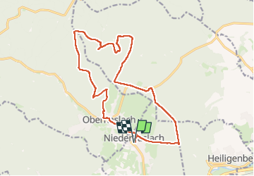
Tocht Stappen van 18,2 km beschikbaar op Grand Est, Bas-Rhin, Niederhaslach. Deze tocht wordt voorgesteld door Bart2015.
Beschrijving
Belle ranado au départ de Niederhaslach, passant par Oberhaslach pour découvrir les ruines des châteaux du Grand et du Petit Ringelstein, puis le Rocher du Pfaffenlapp et sa belle vue, puis le Rocher du Breitberg. La montée vers les châteaux est assez raide ... D'autres découvertes pourront agrémenter la balade ...
Bonne rando, soyez prudent ...
Plaatsbepaling
Opmerkingen
Wandeltochten in de omgeving
![Tocht Stappen Urmatt - Cascade Soultzbach - Urmatt - Photo](https://media.geolcdn.com/t/375/260/20e7652d-0a73-4a1a-a692-b5e1164e2be3.jpg&format=jpg&maxdim=2)
![Stappen Stappen](https://static1.geolcdn.com/sitytour/trail-icons/101.png)
Stappen
![](/images/other/stat-length.png)
![](https://static1.geolcdn.com/siteimages/upload/files/16400158638029165_repeat_loop_refresh_sync_direction_icon.png)
![Tocht Paardrijden Oberhaslach - Neufeld Boucle Elmersforst - Photo](https://media.geolcdn.com/t/375/260/ext.jpg?maxdim=2&url=https%3A%2F%2Fstatic1.geolcdn.com%2Fsiteimages%2Fupload%2Ffiles%2F1524743154cheval.jpg)
![Paardrijden Paardrijden](https://static1.geolcdn.com/sitytour/trail-icons/301.png)
Paardrijden
![](/images/other/stat-length.png)
![](https://static1.geolcdn.com/siteimages/upload/files/16400158638029165_repeat_loop_refresh_sync_direction_icon.png)
![Tocht Mountainbike Niederhaslach - Guirbaden - Grendelbruch - Photo](https://media.geolcdn.com/t/375/260/ext.jpg?maxdim=2&url=https%3A%2F%2Fservices.sitytrail.com%2FGeolivesWS%2FDownloadMedia.ashx%3FTrailID%3D103277%26Media%3D5231_1.jpg)
![Mountainbike Mountainbike](https://static1.geolcdn.com/sitytour/trail-icons/202.png)
Mountainbike
![](/images/other/stat-length.png)
![](https://static1.geolcdn.com/siteimages/upload/files/16400158638029165_repeat_loop_refresh_sync_direction_icon.png)
![Tocht Mountainbike Oberhaslach - Rando des Feuilles Mortes - Photo](https://media.geolcdn.com/t/375/260/ext.jpg?maxdim=2&url=https%3A%2F%2Fservices.sitytrail.com%2FGeolivesWS%2FDownloadMedia.ashx%3FTrailID%3D101060%26Media%3D551_1.jpg)
![Mountainbike Mountainbike](https://static1.geolcdn.com/sitytour/trail-icons/202.png)
Mountainbike
![](/images/other/stat-length.png)
![](https://static1.geolcdn.com/siteimages/upload/files/16400158638029165_repeat_loop_refresh_sync_direction_icon.png)
![Tocht Paardrijden Mollkirch - suuntoapp-HorsebackRiding-2024-04-28T06-24-49Z - Photo](https://media.geolcdn.com/t/375/260/492e641b-5f59-4751-a81d-a41633bc94a3.jpg&format=jpg&maxdim=2)
![Paardrijden Paardrijden](https://static1.geolcdn.com/sitytour/trail-icons/301.png)
Paardrijden
![](/images/other/stat-length.png)
![](https://static1.geolcdn.com/siteimages/upload/files/16400158638029165_repeat_loop_refresh_sync_direction_icon.png)
![Tocht Stappen Still - 2024-02-07_22h30m09_B3 - Photo](https://media.geolcdn.com/t/375/260/ext.jpg?maxdim=2&url=https%3A%2F%2Fstatic1.geolcdn.com%2Fsiteimages%2Fupload%2Ffiles%2F1553511878bg_sport_marche.png)
![Stappen Stappen](https://static1.geolcdn.com/sitytour/trail-icons/101.png)
Stappen
![](/images/other/stat-length.png)
![](https://static1.geolcdn.com/siteimages/upload/files/16400158638029165_repeat_loop_refresh_sync_direction_icon.png)
![Tocht Paardrijden Niederhaslach - Toutes fugues - Photo](https://media.geolcdn.com/t/375/260/ext.jpg?maxdim=2&url=https%3A%2F%2Fstatic1.geolcdn.com%2Fsiteimages%2Fupload%2Ffiles%2F1524743154cheval.jpg)
![Paardrijden Paardrijden](https://static1.geolcdn.com/sitytour/trail-icons/301.png)
Paardrijden
![](/images/other/stat-length.png)
![](https://static1.geolcdn.com/siteimages/upload/files/16400158638029165_repeat_loop_refresh_sync_direction_icon.png)
![Tocht Paardrijden Mollkirch - 2023-05-28 Picnic CVA Cabane des 5 routes - Photo](https://media.geolcdn.com/t/375/260/d96b3efa-5f19-487f-8d02-9856287ebbe7.jpg&format=jpg&maxdim=2)
![Paardrijden Paardrijden](https://static1.geolcdn.com/sitytour/trail-icons/301.png)
Paardrijden
![](/images/other/stat-length.png)
![](https://static1.geolcdn.com/siteimages/upload/files/16400158638029165_repeat_loop_refresh_sync_direction_icon.png)
![Tocht Paardrijden Still - 2022-07-10 Picnic CVA Umwurf depuis Oberhaslach - Photo](https://media.geolcdn.com/t/375/260/345719c4-c8c7-4272-8b46-e89c45a30cba.jpg&format=jpg&maxdim=2)
![Paardrijden Paardrijden](https://static1.geolcdn.com/sitytour/trail-icons/301.png)
Paardrijden
![](/images/other/stat-length.png)
![](https://static1.geolcdn.com/siteimages/upload/files/16400158638029165_repeat_loop_refresh_sync_direction_icon.png)