![](/images/other/stat-length.png)
![Tocht Stappen Goven - Circuit de l'Ermitage - Photo](https://media.geolcdn.com/t/1900/400/ext.pjpeg?maxdim=2&url=https%3A%2F%2Fstatic1.geolcdn.com%2Fsiteimages%2Fupload%2Ffiles%2F1553511878bg_sport_marche.png)
Circuit de l'Ermitage
Marie therese Marteau
Gebruiker
![Lengte](/images/other/stat-length.png)
Lengte
11,5 km
![Max. hoogte](https://static1.geolcdn.com/siteimages/upload/files/1508320355ic_sort_altitude_max_24dp.png)
Max. hoogte
117 m
![Positief hoogteverschil](https://static1.geolcdn.com/siteimages/upload/files/1508320355ic_sort_den_pos_24dp.png)
Positief hoogteverschil
140 m
![Km-Effort](/images/other/stat-length.png)
Km-Effort
13,4 km
![Min. hoogte](https://static1.geolcdn.com/siteimages/upload/files/1508320355ic_sort_altitude_min_24dp.png)
Min. hoogte
64 m
![Negatief hoogteverschil](https://static1.geolcdn.com/siteimages/upload/files/1508320355ic_sort_den_neg_24dp.png)
Negatief hoogteverschil
141 m
![Boucle](https://static1.geolcdn.com/siteimages/upload/files/16400158638029165_repeat_loop_refresh_sync_direction_icon.png)
Boucle
Ja
Datum van aanmaak :
2024-09-15 12:17:35.134
Laatste wijziging :
2024-09-15 12:21:24.375
![Stappen](https://static1.geolcdn.com/sitytour/trail-icons/101.png)
3h02
Moeilijkheid : Moeilijk
![Scan deze QR-code om de tocht te openen in de SityTrail-applicatie](https://capi.geolives.com/qq0zvz2zws4bq2lad0pu/sitytour/trails/4190550/qr.png?size=200)
Gratisgps-wandelapplicatie
Over ons
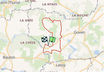
Tocht Stappen van 11,5 km beschikbaar op Bretagne, Ille-et-Vilaine, Goven. Deze tocht wordt voorgesteld door Marie therese Marteau.
Beschrijving
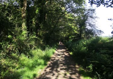
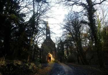
Point de départ, sur le parking près de La Chapelle de l'Ermitage
Direction la Denilais et La Chapelle de l'Hermitage
Plaatsbepaling
Land:
France
Regio :
Bretagne
Departement/Provincie :
Ille-et-Vilaine
Gemeente :
Goven
Locatie:
Unknown
Vertrek:(Dec)
Vertrek:(UTM)
583242 ; 5316306 (30T) N.
Opmerkingen
Wandeltochten in de omgeving
![Tocht Stappen Lassy - canut - Photo](https://media.geolcdn.com/t/375/260/b8ca55a7-8b29-4af0-83f9-f3092173f4b9.jpg&format=jpg&maxdim=2)
![Stappen Stappen](https://static1.geolcdn.com/sitytour/trail-icons/101.png)
canut
Stappen
Heel gemakkelijk
(1)
Lassy,
Bretagne,
Ille-et-Vilaine,
France
![](/images/other/stat-length.png)
3,6 km | 4,5 km-effort
57min
![](https://static1.geolcdn.com/siteimages/upload/files/16400158638029165_repeat_loop_refresh_sync_direction_icon.png)
Ja
![Tocht Stappen Lassy - Les landes de lassy - Photo](https://media.geolcdn.com/t/375/260/ext.jpg?maxdim=2&url=https%3A%2F%2Fstatic1.geolcdn.com%2Fsiteimages%2Fupload%2Ffiles%2F1553511878bg_sport_marche.png)
![Stappen Stappen](https://static1.geolcdn.com/sitytour/trail-icons/101.png)
Les landes de lassy
Stappen
Gemakkelijk
(2)
Lassy,
Bretagne,
Ille-et-Vilaine,
France
![](/images/other/stat-length.png)
8,7 km | 10,7 km-effort
2h 20min
![](https://static1.geolcdn.com/siteimages/upload/files/16400158638029165_repeat_loop_refresh_sync_direction_icon.png)
Ja
![Tocht Te voet Lassy - Circuit des Landes - Photo](https://media.geolcdn.com/t/375/260/7dd3c174-fffa-4d0a-9a6a-d8f005eae851.jpeg&format=jpg&maxdim=2)
![Te voet Te voet](https://static1.geolcdn.com/sitytour/trail-icons/100.png)
Circuit des Landes
Te voet
Gemakkelijk
Lassy,
Bretagne,
Ille-et-Vilaine,
France
![](/images/other/stat-length.png)
8,8 km | 10,9 km-effort
2h 28min
![](https://static1.geolcdn.com/siteimages/upload/files/16400158638029165_repeat_loop_refresh_sync_direction_icon.png)
Ja
![Tocht Te voet Lassy - Circuit des Ruisseaux - Photo](https://media.geolcdn.com/t/375/260/c6412dfd-75e1-4d50-a2a4-3347aade2a27.jpeg&format=jpg&maxdim=2)
![Te voet Te voet](https://static1.geolcdn.com/sitytour/trail-icons/100.png)
Circuit des Ruisseaux
Te voet
Gemakkelijk
Lassy,
Bretagne,
Ille-et-Vilaine,
France
![](/images/other/stat-length.png)
9,9 km | 12 km-effort
2h 44min
![](https://static1.geolcdn.com/siteimages/upload/files/16400158638029165_repeat_loop_refresh_sync_direction_icon.png)
Neen
![Tocht Paard Lassy - Vallée du Ritoir et du Canut - Lassy - Photo](https://media.geolcdn.com/t/375/260/ext.jpg?maxdim=2&url=https%3A%2F%2Fservices.sitytrail.com%2FGeolivesWS%2FDownloadMedia.ashx%3FTrailID%3D317599%26Media%3D16867_3.jpg)
![Paard Paard](https://static1.geolcdn.com/sitytour/trail-icons/300.png)
Vallée du Ritoir et du Canut - Lassy
Paard
Zeer moeilijk
(1)
Lassy,
Bretagne,
Ille-et-Vilaine,
France
![](/images/other/stat-length.png)
66 km | 78 km-effort
6h 30min
![](https://static1.geolcdn.com/siteimages/upload/files/16400158638029165_repeat_loop_refresh_sync_direction_icon.png)
Neen
![Tocht Te voet Goven - La Lande de Caffort - Photo](https://media.geolcdn.com/t/375/260/ext.jpg?maxdim=2&url=https%3A%2F%2Fstatic1.geolcdn.com%2Fsiteimages%2Fupload%2Ffiles%2F1545311037marcheuse_200dpi.jpg)
![Te voet Te voet](https://static1.geolcdn.com/sitytour/trail-icons/100.png)
La Lande de Caffort
Te voet
Gemakkelijk
Goven,
Bretagne,
Ille-et-Vilaine,
France
![](/images/other/stat-length.png)
11,4 km | 13,2 km-effort
3h 0min
![](https://static1.geolcdn.com/siteimages/upload/files/16400158638029165_repeat_loop_refresh_sync_direction_icon.png)
Ja
![Tocht Stappen Baulon - 28.09.2019 - De Baulon-ouest à Maxent - Photo](https://media.geolcdn.com/t/375/260/76bdde4b-813d-4d31-9b59-f38b205d8ab9.jpg&format=jpg&maxdim=2)
![Stappen Stappen](https://static1.geolcdn.com/sitytour/trail-icons/101.png)
28.09.2019 - De Baulon-ouest à Maxent
Stappen
Moeilijk
Baulon,
Bretagne,
Ille-et-Vilaine,
France
![](/images/other/stat-length.png)
30 km | 35 km-effort
8h 3min
![](https://static1.geolcdn.com/siteimages/upload/files/16400158638029165_repeat_loop_refresh_sync_direction_icon.png)
Ja
![Tocht Stappen Bréal-sous-Montfort - breal montfort13 11 22 - Photo](https://media.geolcdn.com/t/375/260/ext.jpg?maxdim=2&url=https%3A%2F%2Fstatic1.geolcdn.com%2Fsiteimages%2Fupload%2Ffiles%2F1553511878bg_sport_marche.png)
![Stappen Stappen](https://static1.geolcdn.com/sitytour/trail-icons/101.png)
breal montfort13 11 22
Stappen
Medium
Bréal-sous-Montfort,
Bretagne,
Ille-et-Vilaine,
France
![](/images/other/stat-length.png)
7,7 km | 8,6 km-effort
2h 22min
![](https://static1.geolcdn.com/siteimages/upload/files/16400158638029165_repeat_loop_refresh_sync_direction_icon.png)
Neen
![Tocht Mountainbike Goven - goven - Photo](https://media.geolcdn.com/t/375/260/49e21261-f5a3-4feb-b6dc-e8d458c15142.jpg&format=jpg&maxdim=2)
![Mountainbike Mountainbike](https://static1.geolcdn.com/sitytour/trail-icons/202.png)
goven
Mountainbike
Gemakkelijk
Goven,
Bretagne,
Ille-et-Vilaine,
France
![](/images/other/stat-length.png)
13,3 km | 15,1 km-effort
1h 6min
![](https://static1.geolcdn.com/siteimages/upload/files/16400158638029165_repeat_loop_refresh_sync_direction_icon.png)
Neen