![](/images/other/stat-length.png)
![Tocht Stappen Wimereux - Les dunes de la Slack - Photo](https://media.geolcdn.com/t/1900/400/ext.pjpeg?maxdim=2&url=https%3A%2F%2Fstatic1.geolcdn.com%2Fsiteimages%2Fupload%2Ffiles%2F1553511878bg_sport_marche.png)
Les dunes de la Slack
micheldutilleul
Gebruiker
![Lengte](/images/other/stat-length.png)
Lengte
12,6 km
![Max. hoogte](https://static1.geolcdn.com/siteimages/upload/files/1508320355ic_sort_altitude_max_24dp.png)
Max. hoogte
41 m
![Positief hoogteverschil](https://static1.geolcdn.com/siteimages/upload/files/1508320355ic_sort_den_pos_24dp.png)
Positief hoogteverschil
107 m
![Km-Effort](/images/other/stat-length.png)
Km-Effort
14 km
![Min. hoogte](https://static1.geolcdn.com/siteimages/upload/files/1508320355ic_sort_altitude_min_24dp.png)
Min. hoogte
0 m
![Negatief hoogteverschil](https://static1.geolcdn.com/siteimages/upload/files/1508320355ic_sort_den_neg_24dp.png)
Negatief hoogteverschil
102 m
![Boucle](https://static1.geolcdn.com/siteimages/upload/files/16400158638029165_repeat_loop_refresh_sync_direction_icon.png)
Boucle
Ja
Datum van aanmaak :
2024-09-14 11:57:39.733
Laatste wijziging :
2024-09-14 16:04:32.76
![Stappen](https://static1.geolcdn.com/sitytour/trail-icons/101.png)
3h05
Moeilijkheid : Medium
![Scan deze QR-code om de tocht te openen in de SityTrail-applicatie](https://capi.geolives.com/qq0zvz2zws4bq2lad0pu/sitytour/trails/4189759/qr.png?size=200)
Gratisgps-wandelapplicatie
Over ons
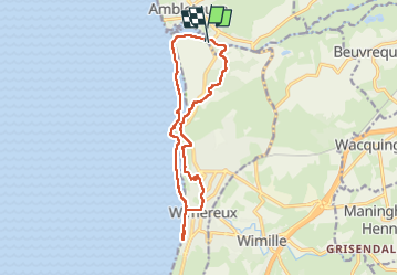
Tocht Stappen van 12,6 km beschikbaar op Hauts-de-France, Pas-de-Calais, Wimereux. Deze tocht wordt voorgesteld door micheldutilleul.
Beschrijving
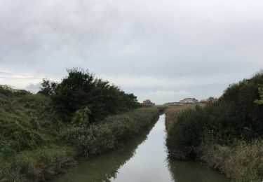
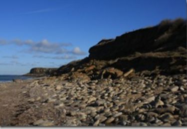
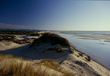
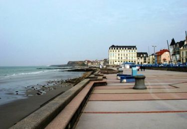
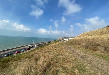
Balade passant le long du littoral, dans la ville de Wimereux, les dunes et les bois.
Tres chouette balade,excepté un passage dans la ville le long du littoral.
Plaatsbepaling
Land:
France
Regio :
Hauts-de-France
Departement/Provincie :
Pas-de-Calais
Gemeente :
Wimereux
Locatie:
Unknown
Vertrek:(Dec)
Vertrek:(UTM)
402242 ; 5628896 (31U) N.
Opmerkingen
Wandeltochten in de omgeving
![Tocht Stappen Wimereux - Promenade des Dunes de la Slack - Photo](https://media.geolcdn.com/t/375/260/ext.jpg?maxdim=2&url=https%3A%2F%2Fservices.sitytrail.com%2FGeolivesWS%2FDownloadMedia.ashx%3FTrailID%3D647521%26Media%3D59f52238-6e50-4f13-bf2d-3775f9e51a6a.jpg)
![Stappen Stappen](https://static1.geolcdn.com/sitytour/trail-icons/101.png)
Promenade des Dunes de la Slack
Stappen
Heel gemakkelijk
(9)
Wimereux,
Hauts-de-France,
Pas-de-Calais,
France
![](/images/other/stat-length.png)
6 km | 6,8 km-effort
1h 30min
![](https://static1.geolcdn.com/siteimages/upload/files/16400158638029165_repeat_loop_refresh_sync_direction_icon.png)
Ja
![Tocht Stappen Wimille - Balade sur le sentier du Denacre - Photo](https://media.geolcdn.com/t/375/260/ext.jpg?maxdim=2&url=https%3A%2F%2Fservices.sitytrail.com%2FGeolivesWS%2FDownloadMedia.ashx%3FTrailID%3D638580%26Media%3Dbb03aebe-b688-479d-8773-5a86670387c9.jpg)
![Stappen Stappen](https://static1.geolcdn.com/sitytour/trail-icons/101.png)
Balade sur le sentier du Denacre
Stappen
Heel gemakkelijk
(5)
Wimille,
Hauts-de-France,
Pas-de-Calais,
France
![](/images/other/stat-length.png)
9,8 km | 11,4 km-effort
2h 30min
![](https://static1.geolcdn.com/siteimages/upload/files/16400158638029165_repeat_loop_refresh_sync_direction_icon.png)
Ja
![Tocht Stappen Audinghen - Sentier cotier Audresselles - Audinghen - Photo](https://media.geolcdn.com/t/375/260/ext.jpg?maxdim=2&url=https%3A%2F%2Fservices.sitytrail.com%2FGeolivesWS%2FDownloadMedia.ashx%3FTrailID%3D106662%26Media%3D11283_3.jpg)
![Stappen Stappen](https://static1.geolcdn.com/sitytour/trail-icons/101.png)
Sentier cotier Audresselles - Audinghen
Stappen
Medium
(1)
Audinghen,
Hauts-de-France,
Pas-de-Calais,
France
![](/images/other/stat-length.png)
5,8 km | 7 km-effort
1h 30min
![](https://static1.geolcdn.com/siteimages/upload/files/16400158638029165_repeat_loop_refresh_sync_direction_icon.png)
Ja
![Tocht Mountainbike Wimereux - Le littoral de Wimereux à Etaples - Photo](https://media.geolcdn.com/t/375/260/ext.jpg?maxdim=2&url=https%3A%2F%2Fservices.sitytrail.com%2FGeolivesWS%2FDownloadMedia.ashx%3FTrailID%3D191453%26Media%3D15044_1.jpg)
![Mountainbike Mountainbike](https://static1.geolcdn.com/sitytour/trail-icons/202.png)
Le littoral de Wimereux à Etaples
Mountainbike
Medium
(1)
Wimereux,
Hauts-de-France,
Pas-de-Calais,
France
![](/images/other/stat-length.png)
35 km | 41 km-effort
3h 0min
![](https://static1.geolcdn.com/siteimages/upload/files/16400158638029165_repeat_loop_refresh_sync_direction_icon.png)
Neen
![Tocht Stappen Wimereux - Wimereux - La Crèche - Photo](https://media.geolcdn.com/t/375/260/ext.jpg?maxdim=2&url=https%3A%2F%2Fservices.sitytrail.com%2FGeolivesWS%2FDownloadMedia.ashx%3FTrailID%3D103740%26Media%3D6466_2.jpg)
![Stappen Stappen](https://static1.geolcdn.com/sitytour/trail-icons/101.png)
Wimereux - La Crèche
Stappen
Medium
(4)
Wimereux,
Hauts-de-France,
Pas-de-Calais,
France
![](/images/other/stat-length.png)
9,3 km | 11,4 km-effort
2h 15min
![](https://static1.geolcdn.com/siteimages/upload/files/16400158638029165_repeat_loop_refresh_sync_direction_icon.png)
Ja
![Tocht Stappen Wimereux - Wimereux Boulogne - Photo](https://media.geolcdn.com/t/375/260/c5b357de-a1ef-4826-80ff-4a1d95018f9a.jpg&format=jpg&maxdim=2)
![Stappen Stappen](https://static1.geolcdn.com/sitytour/trail-icons/101.png)
Wimereux Boulogne
Stappen
Wimereux,
Hauts-de-France,
Pas-de-Calais,
France
![](/images/other/stat-length.png)
8,1 km | 10,1 km-effort
2h 35min
![](https://static1.geolcdn.com/siteimages/upload/files/16400158638029165_repeat_loop_refresh_sync_direction_icon.png)
Ja
![Tocht Te voet Bazinghen - Sentier Les Voyettes - Photo](https://media.geolcdn.com/t/375/260/b6cdb1eb-ec5b-4936-8deb-094b1180094d.jpeg&format=jpg&maxdim=2)
![Te voet Te voet](https://static1.geolcdn.com/sitytour/trail-icons/100.png)
Sentier Les Voyettes
Te voet
Gemakkelijk
Bazinghen,
Hauts-de-France,
Pas-de-Calais,
France
![](/images/other/stat-length.png)
9 km | 11,8 km-effort
2h 41min
![](https://static1.geolcdn.com/siteimages/upload/files/16400158638029165_repeat_loop_refresh_sync_direction_icon.png)
Ja
![Tocht Stappen Audinghen - Audresselles par falaise et campagne - Photo](https://media.geolcdn.com/t/375/260/ext.jpg?maxdim=2&url=https%3A%2F%2Fservices.sitytrail.com%2FGeolivesWS%2FDownloadMedia.ashx%3FTrailID%3D934511%26Media%3Dfix__20180401161107.jpg)
![Stappen Stappen](https://static1.geolcdn.com/sitytour/trail-icons/101.png)
Audresselles par falaise et campagne
Stappen
Medium
Audinghen,
Hauts-de-France,
Pas-de-Calais,
France
![](/images/other/stat-length.png)
6,2 km | 7,3 km-effort
1h 53min
![](https://static1.geolcdn.com/siteimages/upload/files/16400158638029165_repeat_loop_refresh_sync_direction_icon.png)
Ja
![Tocht Stappen Audinghen - Audinghen Sentier des Crans - Photo](https://media.geolcdn.com/t/375/260/ext.jpg?maxdim=2&url=https%3A%2F%2Fstatic1.geolcdn.com%2Fsiteimages%2Fupload%2Ffiles%2F1553511878bg_sport_marche.png)
![Stappen Stappen](https://static1.geolcdn.com/sitytour/trail-icons/101.png)
Audinghen Sentier des Crans
Stappen
Medium
(1)
Audinghen,
Hauts-de-France,
Pas-de-Calais,
France
![](/images/other/stat-length.png)
15,1 km | 17,7 km-effort
3h 53min
![](https://static1.geolcdn.com/siteimages/upload/files/16400158638029165_repeat_loop_refresh_sync_direction_icon.png)
Ja