Tocht  Saint-Martin-de-l'If - 2024-09-09_14h29m54_Cirkwi-Circuit_n°3__Le_Val_au_Cesne - Photo

2024-09-09_14h29m54_Cirkwi-Circuit_n°3__Le_Val_au_Cesne

 MichelRando7656
MichelRando7656

Gebruiker

© OpenStreetMap contributors
Lengte
Lengte
8,9 km
Max. hoogte
Max. hoogte
134 m
Positief hoogteverschil
166 m
Km-Effort
Km-Effort  
11,1 km
Min. hoogte
Min. hoogte
51 m
Negatief hoogteverschil
166 m
Boucle
Boucle
Ja
Datum van aanmaak :
2024-09-09 12:29:55.343
Laatste wijziging :
2024-09-09 12:29:57.546

(0 Bericht)


Scan deze QR-code om de tocht te openen in de SityTrail-applicatie

Gratisgps-wandelapplicatie

Logo SityTrail SityTrail

IGN / Geografische instituten

SityTrail uit de App Store downloaden SityTrail uit Google Play downloaden

Logo SityTrail SityTrail World

De wereld gaat voor u open

SityTrail uit de App Store downloaden SityTrail uit Google Play downloaden SityTrail op Huawei AppGallery downloaden

Over ons

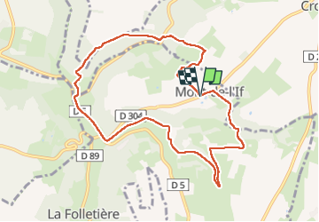
Tocht van 8,9 km beschikbaar op Normandië, Seine-Maritime, Saint-Martin-de-l'If. Deze tocht wordt voorgesteld door MichelRando7656.

Beschrijving

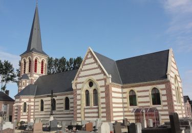
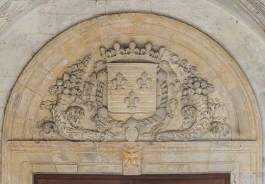
Découvrez l'étonnante mairie de Mont de l'If, construite dans un ancien manège et l'église ouverte toute l'année, pour commencer ce circuit. A mi-chemin, plongez au cœur du Val au Cesne,site naturel classé. Attention, les dénivelés seront importants pour atteindre ce paysage d'exception!

Hoogteprofiel

Plaatsbepaling

Land:
France
Regio :
Normandië
Departement/Provincie :
Seine-Maritime
Gemeente :
Saint-Martin-de-l'If
Locatie:
Mont-de-l'If
Vertrek:(UTM)
342729 ; 5495197 (31U) N.

Wandeltochten in de omgeving

Tocht Te voet Motteville - Circuit de Motteville et Flamanville - Photo
Te voet
GUIDE+

Te voet

Gemakkelijk
Motteville, Normandië, Seine-Maritime, France
4 km | 4,3 km-effort
58min
Neen
Tocht Te voet Yvetot - FR-211a - Photo
Te voet
GUIDE+

Te voet

Gemakkelijk
Yvetot, Normandië, Seine-Maritime, France
9 km | 10,3 km-effort
2h 21min
Neen
Tocht Stappen Touffreville-la-Corbeline - Touffreville la Corbeline - Photo
Stappen
MichelRando7656

Stappen

Moeilijk
(2)
Touffreville-la-Corbeline, Normandië, Seine-Maritime, France
12,4 km | 14,4 km-effort
3h 20min
Ja
Tocht Stappen Écalles-Alix - 076-06-Écalles-Alix 19.5km-738-807  - Photo
Stappen
rvs147

Stappen

Medium
Écalles-Alix, Normandië, Seine-Maritime, France
19,3 km | 23 km-effort
4h 57min
Ja
Tocht sport Saint-Clair-sur-les-Monts - 2024-09-09_14h28m06_Cirkwi-Circuit_n°4__Chemin_de_Boscol(1) - Photo
sport
MichelRando7656

sport

Heel gemakkelijk
Saint-Clair-sur-les-Monts, Normandië, Seine-Maritime, France
9,9 km | 12,1 km-effort
Onbekend
Ja
Tocht Hybride fiets Yvetot - Au fil de la Risle - Photo
Hybride fiets
ves

Hybride fiets

Medium
Yvetot, Normandië, Seine-Maritime, France
178 km | 208 km-effort
Onbekend
Neen
Tocht Stappen Yvetot - Les Fonds de Saint-Clair - Photo
Stappen

Stappen

Gemakkelijk
Yvetot, Normandië, Seine-Maritime, France
13,7 km | 15,7 km-effort
3h 27min
Ja
Tocht Stappen Saint-Martin-de-l'If - Les Héberts - Photo
Stappen

Stappen

Gemakkelijk
(1)
Saint-Martin-de-l'If, Normandië, Seine-Maritime, France
8,9 km | 11,2 km-effort
2h 24min
Ja
Tocht Mountainbike Yvetot - Yvetot St Wandrille - Photo
Mountainbike
ves

Mountainbike

Yvetot, Normandië, Seine-Maritime, France
36 km | 46 km-effort
2h 12min
Neen


Sluiten
Mijn abonnementen