![](/images/other/stat-length.png)
![Tocht Saint-Clair-sur-les-Monts - 2024-09-09_14h28m06_Cirkwi-Circuit_n°4__Chemin_de_Boscol(1) - Photo](https://media.geolcdn.com/t/1900/400/ext.pjpeg?maxdim=2&url=https%3A%2F%2Fsecurestorage.geolives.com%2Fsitytour%2Ftrail-bg%2Fdefault.jpg)
2024-09-09_14h28m06_Cirkwi-Circuit_n°4__Chemin_de_Boscol(1)
MichelRando7656
Gebruiker
![Lengte](/images/other/stat-length.png)
Lengte
9,9 km
![Max. hoogte](https://static1.geolcdn.com/siteimages/upload/files/1508320355ic_sort_altitude_max_24dp.png)
Max. hoogte
144 m
![Positief hoogteverschil](https://static1.geolcdn.com/siteimages/upload/files/1508320355ic_sort_den_pos_24dp.png)
Positief hoogteverschil
162 m
![Km-Effort](/images/other/stat-length.png)
Km-Effort
12,1 km
![Min. hoogte](https://static1.geolcdn.com/siteimages/upload/files/1508320355ic_sort_altitude_min_24dp.png)
Min. hoogte
56 m
![Negatief hoogteverschil](https://static1.geolcdn.com/siteimages/upload/files/1508320355ic_sort_den_neg_24dp.png)
Negatief hoogteverschil
162 m
![Boucle](https://static1.geolcdn.com/siteimages/upload/files/16400158638029165_repeat_loop_refresh_sync_direction_icon.png)
Boucle
Ja
Datum van aanmaak :
2024-09-09 12:28:06.875
Laatste wijziging :
2024-09-09 12:28:09.104
![Scan deze QR-code om de tocht te openen in de SityTrail-applicatie](https://capi.geolives.com/qq0zvz2zws4bq2lad0pu/sitytour/trails/4183879/qr.png?size=200)
Gratisgps-wandelapplicatie
Over ons
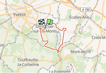
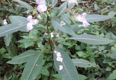
Tocht van 9,9 km beschikbaar op Normandië, Seine-Maritime, Saint-Clair-sur-les-Monts. Deze tocht wordt voorgesteld door MichelRando7656.
Beschrijving
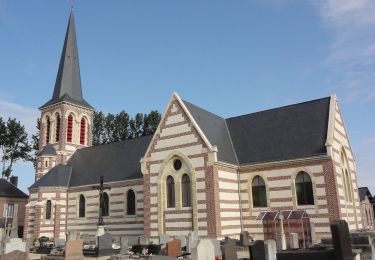
Cet itinéraire balisé en jaune vous offre l'opportunité de vous balader dans deux bois, celui de Côte Bailleul et de la Bretèque, et de découvrir la commune de Saint-Clair-sur-les-Monts, son église et ses châteaux.
Plaatsbepaling
Land:
France
Regio :
Normandië
Departement/Provincie :
Seine-Maritime
Gemeente :
Saint-Clair-sur-les-Monts
Locatie:
Unknown
Vertrek:(Dec)
Vertrek:(UTM)
339972 ; 5497328 (31U) N.
Opmerkingen
Wandeltochten in de omgeving
![Tocht Te voet Ectot-lès-Baons - Circuit d'Ectot-les-Baons - Relais du Gal - Photo](https://media.geolcdn.com/t/375/260/193066fb-73ff-45a2-bec1-3c12d5995c81.jpeg&format=jpg&maxdim=2)
![Te voet Te voet](https://static1.geolcdn.com/sitytour/trail-icons/100.png)
Circuit d'Ectot-les-Baons - Relais du Gal
Te voet
Gemakkelijk
Ectot-lès-Baons,
Normandië,
Seine-Maritime,
France
![](/images/other/stat-length.png)
6,7 km | 7,2 km-effort
1h 37min
![](https://static1.geolcdn.com/siteimages/upload/files/16400158638029165_repeat_loop_refresh_sync_direction_icon.png)
Neen
![Tocht Te voet Motteville - Circuit de Motteville et Flamanville - Photo](https://media.geolcdn.com/t/375/260/e953aee2-f166-4dd5-ac77-706204a34505.jpeg&format=jpg&maxdim=2)
![Te voet Te voet](https://static1.geolcdn.com/sitytour/trail-icons/100.png)
Circuit de Motteville et Flamanville
Te voet
Gemakkelijk
Motteville,
Normandië,
Seine-Maritime,
France
![](/images/other/stat-length.png)
4 km | 4,3 km-effort
58min
![](https://static1.geolcdn.com/siteimages/upload/files/16400158638029165_repeat_loop_refresh_sync_direction_icon.png)
Neen
![Tocht Te voet Yvetot - FR-211a - Photo](https://media.geolcdn.com/t/375/260/75d4786a-c043-4388-8a3f-e6a629b9c0a0.jpeg&format=jpg&maxdim=2)
![Te voet Te voet](https://static1.geolcdn.com/sitytour/trail-icons/100.png)
FR-211a
Te voet
Gemakkelijk
Yvetot,
Normandië,
Seine-Maritime,
France
![](/images/other/stat-length.png)
9 km | 10,3 km-effort
2h 21min
![](https://static1.geolcdn.com/siteimages/upload/files/16400158638029165_repeat_loop_refresh_sync_direction_icon.png)
Neen
![Tocht Stappen Touffreville-la-Corbeline - Touffreville la Corbeline - Photo](https://media.geolcdn.com/t/375/260/31d84955-18d5-45fc-b4b0-2c94089d9527.jpg&format=jpg&maxdim=2)
![Stappen Stappen](https://static1.geolcdn.com/sitytour/trail-icons/101.png)
Touffreville la Corbeline
Stappen
Moeilijk
(2)
Touffreville-la-Corbeline,
Normandië,
Seine-Maritime,
France
![](/images/other/stat-length.png)
12,4 km | 14,4 km-effort
3h 20min
![](https://static1.geolcdn.com/siteimages/upload/files/16400158638029165_repeat_loop_refresh_sync_direction_icon.png)
Ja
![Tocht Stappen Écalles-Alix - 076-06-Écalles-Alix 19.5km-738-807 - Photo](https://media.geolcdn.com/t/375/260/d5ac8eaf-6461-4f56-9199-c81d638b404e.jpg&format=jpg&maxdim=2)
![Stappen Stappen](https://static1.geolcdn.com/sitytour/trail-icons/101.png)
076-06-Écalles-Alix 19.5km-738-807
Stappen
Medium
Écalles-Alix,
Normandië,
Seine-Maritime,
France
![](/images/other/stat-length.png)
19,3 km | 23 km-effort
4h 57min
![](https://static1.geolcdn.com/siteimages/upload/files/16400158638029165_repeat_loop_refresh_sync_direction_icon.png)
Ja
![Tocht sport Saint-Martin-de-l'If - 2024-09-09_14h29m54_Cirkwi-Circuit_n°3__Le_Val_au_Cesne - Photo](https://media.geolcdn.com/t/375/260/ext.jpg?maxdim=2&url=https%3A%2F%2Fsecurestorage.geolives.com%2Fsitytour%2Ftrail-bg%2Fdefault.jpg)
2024-09-09_14h29m54_Cirkwi-Circuit_n°3__Le_Val_au_Cesne
sport
Heel gemakkelijk
(1)
Saint-Martin-de-l'If,
Normandië,
Seine-Maritime,
France
![](/images/other/stat-length.png)
8,9 km | 11,1 km-effort
Onbekend
![](https://static1.geolcdn.com/siteimages/upload/files/16400158638029165_repeat_loop_refresh_sync_direction_icon.png)
Ja
![Tocht Hybride fiets Yvetot - Au fil de la Risle - Photo](https://media.geolcdn.com/t/375/260/ext.jpg?maxdim=2&url=https%3A%2F%2Fstatic1.geolcdn.com%2Fsiteimages%2Fupload%2Ffiles%2F1524743154velo.jpg)
![Hybride fiets Hybride fiets](https://static1.geolcdn.com/sitytour/trail-icons/203.png)
Au fil de la Risle
Hybride fiets
Medium
Yvetot,
Normandië,
Seine-Maritime,
France
![](/images/other/stat-length.png)
178 km | 208 km-effort
Onbekend
![](https://static1.geolcdn.com/siteimages/upload/files/16400158638029165_repeat_loop_refresh_sync_direction_icon.png)
Neen
![Tocht Stappen Yvetot - Les Fonds de Saint-Clair - Photo](https://media.geolcdn.com/t/375/260/ext.jpg?maxdim=2&url=https%3A%2F%2Fstatic1.geolcdn.com%2Fsiteimages%2Fupload%2Ffiles%2F1553511878bg_sport_marche.png)
![Stappen Stappen](https://static1.geolcdn.com/sitytour/trail-icons/101.png)
Les Fonds de Saint-Clair
Stappen
Gemakkelijk
Yvetot,
Normandië,
Seine-Maritime,
France
![](/images/other/stat-length.png)
13,7 km | 15,7 km-effort
3h 27min
![](https://static1.geolcdn.com/siteimages/upload/files/16400158638029165_repeat_loop_refresh_sync_direction_icon.png)
Ja
![Tocht Mountainbike Yvetot - Yvetot St Wandrille - Photo](https://media.geolcdn.com/t/375/260/ext.jpg?maxdim=2&url=https%3A%2F%2Fstatic1.geolcdn.com%2Fsiteimages%2Fupload%2Ffiles%2F1524743154velo.jpg)
![Mountainbike Mountainbike](https://static1.geolcdn.com/sitytour/trail-icons/202.png)
Yvetot St Wandrille
Mountainbike
Yvetot,
Normandië,
Seine-Maritime,
France
![](/images/other/stat-length.png)
36 km | 46 km-effort
2h 12min
![](https://static1.geolcdn.com/siteimages/upload/files/16400158638029165_repeat_loop_refresh_sync_direction_icon.png)
Neen