Tocht Stappen Vivès - VIVES - 66 - boucle Vives St-Jean-Pla-De-Corts  - Photo

VIVES - 66 - boucle Vives St-Jean-Pla-De-Corts

 jeff66
jeff66

Gebruiker

© OpenStreetMap contributors
Lengte
Lengte
10,4 km
Max. hoogte
Max. hoogte
263 m
Positief hoogteverschil
233 m
Km-Effort
Km-Effort  
13,5 km
Min. hoogte
Min. hoogte
108 m
Negatief hoogteverschil
234 m
Boucle
Boucle
Ja
Datum van aanmaak :
2015-05-12 00:00:00.0
Laatste wijziging :
2015-05-12 00:00:00.0

(2 Bericht)

Stappen
Stappen
1h50
Moeilijkheid : Medium

Scan deze QR-code om de tocht te openen in de SityTrail-applicatie

Gratisgps-wandelapplicatie

Logo SityTrail SityTrail

IGN / Geografische instituten

SityTrail uit de App Store downloaden SityTrail uit Google Play downloaden

Logo SityTrail SityTrail World

De wereld gaat voor u open

SityTrail uit de App Store downloaden SityTrail uit Google Play downloaden SityTrail op Huawei AppGallery downloaden

Over ons

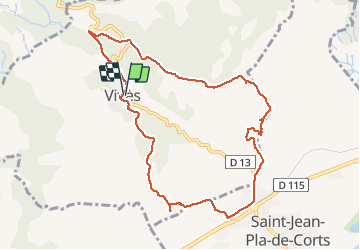
Tocht Stappen van 10,4 km beschikbaar op Occitanië, Pyrénées-Orientales, Vivès. Deze tocht wordt voorgesteld door jeff66.

Beschrijving

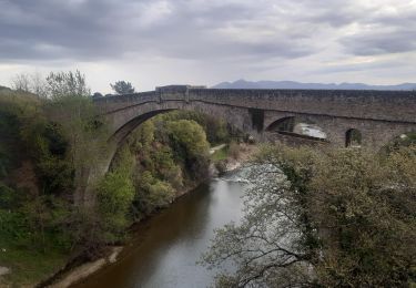
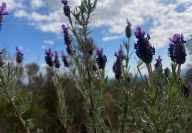
VIVES - 66 - chemin de Vives - chemin du Liège - boucle Vives / St-Jean-Pla-De-Corts - vue sur le Canigou - antennes relais - institut méditerranéen du Liège - balcon des Aspres - panorama sur les Albères la côte - mas des amandiers - maison abandonnée réservoir 429 - table d'orientation - St Jean Pla de Corts - chapelle St Sébastien - chateau d'Aubiry - mas Santa  Teresa -

Hoogteprofiel

Foto's

Plaatsbepaling

Land:
France
Regio :
Occitanië
Departement/Provincie :
Pyrénées-Orientales
Gemeente :
Vivès
Locatie:
Unknown
Vertrek:(Dec)
Vertrek:(UTM)
480662 ; 4708531 (31T) N.

Opmerkingen

Gelieve in te loggen om een commentaar of een beoordeling achter te laten


Wandeltochten in de omgeving

Tocht Stappen Le Boulou - rando de la bataille du Boulou - Photo
Stappen
GUIDE
stef789

Stappen

Zeer moeilijk
(1)
Le Boulou, Occitanië, Pyrénées-Orientales, France
8,4 km | 10,5 km-effort
3h 27min
Ja
Tocht Stappen Céret - Céret pont du Diable . Saint Feriol (boucle sens aiguilles de la montre) - Photo
Stappen
GUIDE
stef789

Stappen

Gemakkelijk
(1)
Céret, Occitanië, Pyrénées-Orientales, France
8,5 km | 11,9 km-effort
3h 44min
Ja
Tocht Stappen Vivès - Le sentier de Vinés - Photo
Stappen
bernarb

Stappen

Gemakkelijk
(2)
Vivès, Occitanië, Pyrénées-Orientales, France
9,9 km | 13 km-effort
2h 54min
Ja
Tocht Stappen Saint-Jean-Pla-de-Corts - 66 ST-JEAN-PLA-DE-CORTS, promenade autour du Tech, jusqu'au BOULOU  - Photo
Stappen
jeff66

Stappen

Gemakkelijk
(1)
Saint-Jean-Pla-de-Corts, Occitanië, Pyrénées-Orientales, France
7,9 km | 8,8 km-effort
1h 18min
Ja
Tocht Stappen Tordères - 66 TORDÈRES - LLAURO, promenade en forêt méditerranéenne, cistes, genêts, bruyères. Arbousiers, chênes Lièges, chênes verts, pins - Photo
Stappen
jeff66

Stappen

Moeilijk
(1)
Tordères, Occitanië, Pyrénées-Orientales, France
11,9 km | 17,5 km-effort
2h 23min
Ja
Tocht Stappen Vivès - Vives llauro  - Photo
Stappen
GUIDE
antignacs

Stappen

Heel gemakkelijk
Vivès, Occitanië, Pyrénées-Orientales, France
8,2 km | 11,7 km-effort
2h 15min
Ja
Tocht Stappen Le Boulou - Bataille du Boulou (1793 - 1794) - Photo
Stappen
GUIDE
toutankhcarton

Stappen

Heel gemakkelijk
Le Boulou, Occitanië, Pyrénées-Orientales, France
10,4 km | 13,2 km-effort
1h 57min
Ja
Tocht Hybride fiets Le Boulou - Autour du Boulou (66) - Photo
Hybride fiets
GUIDE
toutankhcarton

Hybride fiets

Gemakkelijk
Le Boulou, Occitanië, Pyrénées-Orientales, France
17 km | 19,5 km-effort
1h 54min
Neen
Tocht Stappen Céret - Ermitage de saint ferreol - Photo
Stappen
philippe66

Stappen

Medium
(1)
Céret, Occitanië, Pyrénées-Orientales, France
7,6 km | 10,4 km-effort
1h 59min
Ja


Sluiten
Mijn abonnementen