![](/images/other/stat-length.png)
![Tocht Paard Malling - RGE 2024 - Sibylline & Risueno - Photo](https://media.geolcdn.com/t/1900/400/ext.pjpeg?maxdim=2&url=https%3A%2F%2Fstatic1.geolcdn.com%2Fsiteimages%2Fupload%2Ffiles%2F1524743154cheval.jpg)
RGE 2024 - Sibylline & Risueno
Sibylline Chopin
Gebruiker
![Lengte](/images/other/stat-length.png)
Lengte
132 km
![Max. hoogte](https://static1.geolcdn.com/siteimages/upload/files/1508320355ic_sort_altitude_max_24dp.png)
Max. hoogte
415 m
![Positief hoogteverschil](https://static1.geolcdn.com/siteimages/upload/files/1508320355ic_sort_den_pos_24dp.png)
Positief hoogteverschil
2567 m
![Km-Effort](/images/other/stat-length.png)
Km-Effort
167 km
![Min. hoogte](https://static1.geolcdn.com/siteimages/upload/files/1508320355ic_sort_altitude_min_24dp.png)
Min. hoogte
141 m
![Negatief hoogteverschil](https://static1.geolcdn.com/siteimages/upload/files/1508320355ic_sort_den_neg_24dp.png)
Negatief hoogteverschil
2566 m
![Boucle](https://static1.geolcdn.com/siteimages/upload/files/16400158638029165_repeat_loop_refresh_sync_direction_icon.png)
Boucle
Neen
Datum van aanmaak :
2024-08-27 07:11:24.587
Laatste wijziging :
2024-08-27 07:27:29.965
![Paard](https://static1.geolcdn.com/sitytour/trail-icons/300.png)
0m
Moeilijkheid : Medium
![Scan deze QR-code om de tocht te openen in de SityTrail-applicatie](https://capi.geolives.com/qq0zvz2zws4bq2lad0pu/sitytour/trails/4169800/qr.png?size=200)
Gratisgps-wandelapplicatie
Over ons
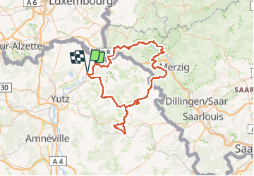
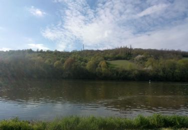
Tocht Paard van 132 km beschikbaar op Grand Est, Moselle, Malling. Deze tocht wordt voorgesteld door Sibylline Chopin.
Beschrijving
30/07 : ANZELING → MONNEREN
31/07 : MONNEREN → MALLING
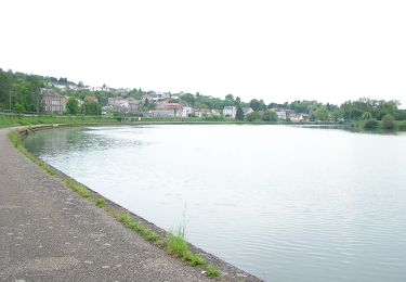
01/08 : MALLING → SIERCK
02/08 : SIERCK → ORSCHOLZ
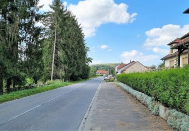
03/08 : ORSCHOLZ → HILBRINGEN
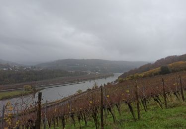
04/08 : HILBRINGEN → FERANGE
05/08 : FERANGE → ANZELING
Plaatsbepaling
Land:
France
Regio :
Grand Est
Departement/Provincie :
Moselle
Gemeente :
Malling
Locatie:
Unknown
Vertrek:(Dec)
Vertrek:(UTM)
304274 ; 5478597 (32U) N.
Opmerkingen
Wandeltochten in de omgeving
![Tocht Te voet Contz-les-Bains - Schengen grenzenlos / sans frontières - Photo](https://media.geolcdn.com/t/375/260/45497cda-a7e7-4df9-a6a1-692f43d5633d.jpeg&format=jpg&maxdim=2)
![Te voet Te voet](https://static1.geolcdn.com/sitytour/trail-icons/100.png)
Schengen grenzenlos / sans frontières
Te voet
Gemakkelijk
Contz-les-Bains,
Grand Est,
Moselle,
France
![](/images/other/stat-length.png)
3,3 km | 4,6 km-effort
1h 3min
![](https://static1.geolcdn.com/siteimages/upload/files/16400158638029165_repeat_loop_refresh_sync_direction_icon.png)
Neen
![Tocht Stappen Sierck-les-Bains - Sierck Montenach - Photo](https://media.geolcdn.com/t/375/260/ext.jpg?maxdim=2&url=https%3A%2F%2Fstatic1.geolcdn.com%2Fsiteimages%2Fupload%2Ffiles%2F1553511878bg_sport_marche.png)
![Stappen Stappen](https://static1.geolcdn.com/sitytour/trail-icons/101.png)
Sierck Montenach
Stappen
Medium
(1)
Sierck-les-Bains,
Grand Est,
Moselle,
France
![](/images/other/stat-length.png)
15,5 km | 20 km-effort
4h 4min
![](https://static1.geolcdn.com/siteimages/upload/files/16400158638029165_repeat_loop_refresh_sync_direction_icon.png)
Ja
![Tocht Te voet Beyren-lès-Sierck - Boucle de Gandren - Photo](https://media.geolcdn.com/t/375/260/5da9b68e-a1da-46d8-9a5b-cfbd6f365254.jpeg&format=jpg&maxdim=2)
![Te voet Te voet](https://static1.geolcdn.com/sitytour/trail-icons/100.png)
Boucle de Gandren
Te voet
Gemakkelijk
Beyren-lès-Sierck,
Grand Est,
Moselle,
France
![](/images/other/stat-length.png)
8,3 km | 10,7 km-effort
2h 25min
![](https://static1.geolcdn.com/siteimages/upload/files/16400158638029165_repeat_loop_refresh_sync_direction_icon.png)
Ja
![Tocht Te voet Sierck-les-Bains - Sentier Sierck-Apach-Montenach - Photo](https://media.geolcdn.com/t/375/260/62837726-a782-4202-8c71-f77c72a6a6b2.jpeg&format=jpg&maxdim=2)
![Te voet Te voet](https://static1.geolcdn.com/sitytour/trail-icons/100.png)
Sentier Sierck-Apach-Montenach
Te voet
Moeilijk
Sierck-les-Bains,
Grand Est,
Moselle,
France
![](/images/other/stat-length.png)
23 km | 31 km-effort
7h 4min
![](https://static1.geolcdn.com/siteimages/upload/files/16400158638029165_repeat_loop_refresh_sync_direction_icon.png)
Ja
![Tocht Te voet Sierck-les-Bains - CV SentierKoenigsberg - Photo](https://media.geolcdn.com/t/375/260/867e519c-1be9-46c2-afcc-d89ebb2bfb6e.jpeg&format=jpg&maxdim=2)
![Te voet Te voet](https://static1.geolcdn.com/sitytour/trail-icons/100.png)
CV SentierKoenigsberg
Te voet
Gemakkelijk
Sierck-les-Bains,
Grand Est,
Moselle,
France
![](/images/other/stat-length.png)
6,2 km | 8 km-effort
1h 49min
![](https://static1.geolcdn.com/siteimages/upload/files/16400158638029165_repeat_loop_refresh_sync_direction_icon.png)
Neen
![Tocht Te voet Schengen - Sentier Grouf - Photo](https://media.geolcdn.com/t/375/260/eeb086f6-5a54-4928-a6cd-8cc9bb48fe81.jpeg&format=jpg&maxdim=2)
![Te voet Te voet](https://static1.geolcdn.com/sitytour/trail-icons/100.png)
Sentier Grouf
Te voet
Gemakkelijk
Schengen,
Onbekend,
Canton Remich,
Luxembourg
![](/images/other/stat-length.png)
4,2 km | 5,6 km-effort
1h 15min
![](https://static1.geolcdn.com/siteimages/upload/files/16400158638029165_repeat_loop_refresh_sync_direction_icon.png)
Ja
![Tocht Noords wandelen Schengen - Etape 1 GR5 - E2 - Photo](https://media.geolcdn.com/t/375/260/b4b91d50-d0e7-401f-8936-e17eb846540c.jpg&format=jpg&maxdim=2)
![Noords wandelen Noords wandelen](https://static1.geolcdn.com/sitytour/trail-icons/102.png)
Etape 1 GR5 - E2
Noords wandelen
Medium
Schengen,
Onbekend,
Canton Remich,
Luxembourg
![](/images/other/stat-length.png)
30 km | 41 km-effort
7h 8min
![](https://static1.geolcdn.com/siteimages/upload/files/16400158638029165_repeat_loop_refresh_sync_direction_icon.png)
Neen
![Tocht Stappen Sierck-les-Bains - duc de Lorraine malbrouck - Photo](https://media.geolcdn.com/t/375/260/b5269330-cc71-492d-a405-806eec329ed3.jpg&format=jpg&maxdim=2)
![Stappen Stappen](https://static1.geolcdn.com/sitytour/trail-icons/101.png)
duc de Lorraine malbrouck
Stappen
Zeer moeilijk
Sierck-les-Bains,
Grand Est,
Moselle,
France
![](/images/other/stat-length.png)
28 km | 36 km-effort
8h 22min
![](https://static1.geolcdn.com/siteimages/upload/files/16400158638029165_repeat_loop_refresh_sync_direction_icon.png)
Neen
![Tocht Te voet Schengen - Moselle³ Trail - Photo](https://media.geolcdn.com/t/375/260/03fbe93a-df36-4f92-b452-262fac3cf70e.jpeg&format=jpg&maxdim=2)
![Te voet Te voet](https://static1.geolcdn.com/sitytour/trail-icons/100.png)
Moselle³ Trail
Te voet
Zeer moeilijk
Schengen,
Onbekend,
Canton Remich,
Luxembourg
![](/images/other/stat-length.png)
32 km | 45 km-effort
10h 9min
![](https://static1.geolcdn.com/siteimages/upload/files/16400158638029165_repeat_loop_refresh_sync_direction_icon.png)
Ja