![](/images/other/stat-length.png)
![Tocht Stappen Avaux - Avaux-Asfeld AR - Photo](https://media.geolcdn.com/t/1900/400/ext.pjpeg?maxdim=2&url=https%3A%2F%2Fstatic1.geolcdn.com%2Fsiteimages%2Fupload%2Ffiles%2F1553511878bg_sport_marche.png)
Avaux-Asfeld AR
mick211
Gebruiker
![Lengte](/images/other/stat-length.png)
Lengte
11 km
![Max. hoogte](https://static1.geolcdn.com/siteimages/upload/files/1508320355ic_sort_altitude_max_24dp.png)
Max. hoogte
80 m
![Positief hoogteverschil](https://static1.geolcdn.com/siteimages/upload/files/1508320355ic_sort_den_pos_24dp.png)
Positief hoogteverschil
72 m
![Km-Effort](/images/other/stat-length.png)
Km-Effort
12 km
![Min. hoogte](https://static1.geolcdn.com/siteimages/upload/files/1508320355ic_sort_altitude_min_24dp.png)
Min. hoogte
56 m
![Negatief hoogteverschil](https://static1.geolcdn.com/siteimages/upload/files/1508320355ic_sort_den_neg_24dp.png)
Negatief hoogteverschil
72 m
![Boucle](https://static1.geolcdn.com/siteimages/upload/files/16400158638029165_repeat_loop_refresh_sync_direction_icon.png)
Boucle
Ja
Datum van aanmaak :
2015-09-30 00:00:00.0
Laatste wijziging :
2015-09-30 00:00:00.0
![Stappen](https://static1.geolcdn.com/sitytour/trail-icons/101.png)
2h40
Moeilijkheid : Heel gemakkelijk
![Scan deze QR-code om de tocht te openen in de SityTrail-applicatie](https://capi.geolives.com/qq0zvz2zws4bq2lad0pu/sitytour/trails/416948/qr.png?size=200)
Gratisgps-wandelapplicatie
Over ons
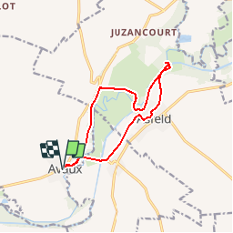
Tocht Stappen van 11 km beschikbaar op Grand Est, Ardennes, Avaux. Deze tocht wordt voorgesteld door mick211.
Beschrijving
Rando le long du canal et de la rivière Aisne.
Depart Avaux
A voire: Arrivé a l'écluse traverser le pont à gauche, aller jusque au bord de la riviere (barrage)
Petite Chapelle a l'entrée d'Asfeld sur le chemin du retour.
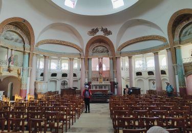
Ne pas rater Eglise St Didier construction de style unique au monde
Plaatsbepaling
Land:
France
Regio :
Grand Est
Departement/Provincie :
Ardennes
Gemeente :
Avaux
Locatie:
Unknown
Vertrek:(Dec)
Vertrek:(UTM)
578552 ; 5478710 (31U) N.
Opmerkingen
Wandeltochten in de omgeving
![Tocht Stappen Vieux-lès-Asfeld - Chemin de Compostelle, Voie de Vézelay GR654® De Vieux lès Asfeld à Reims - Photo](https://media.geolcdn.com/t/375/260/ext.jpg?maxdim=2&url=https%3A%2F%2Fservices.sitytrail.com%2FGeolivesWS%2FDownloadMedia.ashx%3FTrailID%3D109400%26Media%3D3731_1.jpg)
![Stappen Stappen](https://static1.geolcdn.com/sitytour/trail-icons/101.png)
Chemin de Compostelle, Voie de Vézelay GR654® De Vieux lès Asfeld à Reims
Stappen
Moeilijk
Vieux-lès-Asfeld,
Grand Est,
Ardennes,
France
![](/images/other/stat-length.png)
26 km | 28 km-effort
5h 15min
![](https://static1.geolcdn.com/siteimages/upload/files/16400158638029165_repeat_loop_refresh_sync_direction_icon.png)
Neen
![Tocht Stappen Vieux-lès-Asfeld - 23_08_2024_Vieux les Asfeld - Photo](https://media.geolcdn.com/t/375/260/e1b82c5b-e96f-4be0-bff2-db08cf3ee224.jpg&format=jpg&maxdim=2)
![Stappen Stappen](https://static1.geolcdn.com/sitytour/trail-icons/101.png)
23_08_2024_Vieux les Asfeld
Stappen
Medium
Vieux-lès-Asfeld,
Grand Est,
Ardennes,
France
![](/images/other/stat-length.png)
8,6 km | 9,2 km-effort
2h 5min
![](https://static1.geolcdn.com/siteimages/upload/files/16400158638029165_repeat_loop_refresh_sync_direction_icon.png)
Ja
![Tocht Stappen Asfeld - Asfeld- Vieux les Asfeld A-R - Photo](https://media.geolcdn.com/t/375/260/ext.jpg?maxdim=2&url=https%3A%2F%2Fstatic1.geolcdn.com%2Fsiteimages%2Fupload%2Ffiles%2F1553511878bg_sport_marche.png)
![Stappen Stappen](https://static1.geolcdn.com/sitytour/trail-icons/101.png)
Asfeld- Vieux les Asfeld A-R
Stappen
Heel gemakkelijk
(1)
Asfeld,
Grand Est,
Ardennes,
France
![](/images/other/stat-length.png)
7,2 km | 7,8 km-effort
1h 44min
![](https://static1.geolcdn.com/siteimages/upload/files/16400158638029165_repeat_loop_refresh_sync_direction_icon.png)
Ja
![Tocht Stappen Avaux - Avaux-Asfeld AR - Photo](https://media.geolcdn.com/t/375/260/ext.jpg?maxdim=2&url=https%3A%2F%2Fstatic1.geolcdn.com%2Fsiteimages%2Fupload%2Ffiles%2F1553511878bg_sport_marche.png)
![Stappen Stappen](https://static1.geolcdn.com/sitytour/trail-icons/101.png)
Avaux-Asfeld AR
Stappen
Heel gemakkelijk
Avaux,
Grand Est,
Ardennes,
France
![](/images/other/stat-length.png)
11 km | 12 km-effort
2h 40min
![](https://static1.geolcdn.com/siteimages/upload/files/16400158638029165_repeat_loop_refresh_sync_direction_icon.png)
Ja