Tocht Fiets Serdinya - La Bastide d'Olette # - Photo
 RjR
RjR

Gebruiker

© OpenStreetMap contributors
Lengte
Lengte
4,1 km
Max. hoogte
Max. hoogte
591 m
Positief hoogteverschil
43 m
Km-Effort
Km-Effort  
4,8 km
Min. hoogte
Min. hoogte
523 m
Negatief hoogteverschil
89 m
Boucle
Boucle
Neen
Datum van aanmaak :
2017-05-29 00:00:00.0
Laatste wijziging :
2017-05-29 00:00:00.0

(0 Bericht)

Fiets
Fiets
18m
Moeilijkheid : Gemakkelijk

Scan deze QR-code om de tocht te openen in de SityTrail-applicatie

Gratisgps-wandelapplicatie

Logo SityTrail SityTrail

IGN / Geografische instituten

SityTrail uit de App Store downloaden SityTrail uit Google Play downloaden

Logo SityTrail SityTrail World

De wereld gaat voor u open

SityTrail uit de App Store downloaden SityTrail uit Google Play downloaden SityTrail op Huawei AppGallery downloaden

Over ons

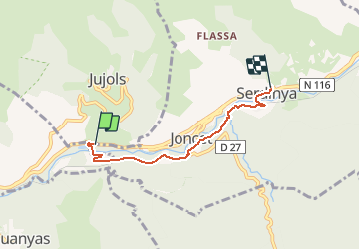
Tocht Fiets van 4,1 km beschikbaar op Occitanië, Pyrénées-Orientales, Serdinya. Deze tocht wordt voorgesteld door RjR.

Beschrijving

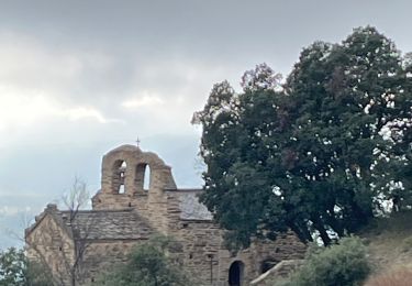
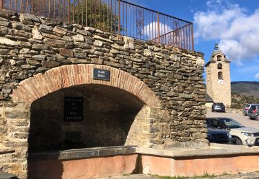
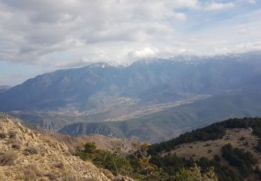
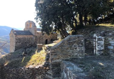
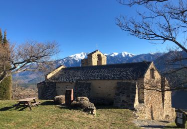
Itinéraire longeant la voie du train jaune. N 116 -> La Bastide d'Olette -> Joncet el Bac, par chemin vélos & voitures, puis route D27 (à Escaro / Sahorre) -> Joncet el Bac, chapelle -> Serdinya,
par route goudronnée. -> N 116.

Hoogteprofiel

POI's

POI Olette - maison du P N R - Photo
RjR
POI Serdinya - barrière levante - Photo
RjR
POI Serdinya - barrière levante - Photo
RjR
POI Serdinya - train - Photo
RjR
SERDINYA 
POI Serdinya - voie - Photo
RjR
SERDINYA 
POI Serdinya - voie - Photo
RjR
SERDINYA 
POI Serdinya - route - Photo
RjR
SERDINYA 
POI Serdinya - route - Photo
RjR
SERDINYA 
POI Serdinya - route - Photo
RjR
SERDINYA 
POI Serdinya - rue - Photo
RjR
SERDINYA 
POI Serdinya - rue - Photo
RjR
SERDINYA 
POI Serdinya - église - Photo
RjR
SERDINYA 

Plaatsbepaling

Land:
France
Regio :
Occitanië
Departement/Provincie :
Pyrénées-Orientales
Gemeente :
Serdinya
Locatie:
Unknown
Vertrek:(Dec)
Vertrek:(UTM)
441966 ; 4712383 (31T) N.

Wandeltochten in de omgeving

Tocht Stappen Olette - Evol village et chateau ( Olette) - Photo
Stappen
Joël.cof

Stappen

Gemakkelijk
(1)
Olette, Occitanië, Pyrénées-Orientales, France
3,2 km | 5,6 km-effort
1h 16min
Ja
Tocht Stappen Jujols - Jujols 1 - Photo
Stappen
jcmartin

Stappen

Medium
(1)
Jujols, Occitanië, Pyrénées-Orientales, France
13,2 km | 22 km-effort
4h 2min
Ja
Tocht Stappen Jujols - jujols marbre rouge  - Photo
Stappen
66Gribouille83

Stappen

Zeer moeilijk
Jujols, Occitanië, Pyrénées-Orientales, France
16,5 km | 28 km-effort
9h 13min
Ja
Tocht Stappen Sahorre - Thorrent - Py et le Rec de Thorrent - Photo
Stappen
Jean-marie Compta

Stappen

Medium
Sahorre, Occitanië, Pyrénées-Orientales, France
18,5 km | 30 km-effort
5h 33min
Ja
Tocht Stappen Canaveilles - 20221120 Canaveilles - Llar  - Photo
Stappen
ThonyM

Stappen

Medium
Canaveilles, Occitanië, Pyrénées-Orientales, France
11 km | 20 km-effort
3h 15min
Ja
Tocht Stappen Serdinya - flassa. taratera 850 positif 13km 4h30 - Photo
Stappen
Erius

Stappen

Zeer moeilijk
Serdinya, Occitanië, Pyrénées-Orientales, France
13,8 km | 25 km-effort
4h 21min
Ja
Tocht Stappen Fuilla - 20220112 horts  - Photo
Stappen
ThonyM

Stappen

Moeilijk
Fuilla, Occitanië, Pyrénées-Orientales, France
14,6 km | 27 km-effort
4h 31min
Ja
Tocht Stappen Olette - 20211216 Olette - Photo
Stappen
ThonyM

Stappen

Medium
Olette, Occitanië, Pyrénées-Orientales, France
16 km | 28 km-effort
5h 8min
Ja
Tocht Stappen Escaro - 20210530 au départ du col de Fins - Photo
Stappen
ThonyM

Stappen

Moeilijk
Escaro, Occitanië, Pyrénées-Orientales, France
19,3 km | 38 km-effort
6h 3min
Ja


Sluiten
Mijn abonnementen