![](/images/other/stat-length.png)
![Tocht Stappen Pujo-le-Plan - autour de Pujo le Plan - Photo](https://media.geolcdn.com/t/1900/400/ext.pjpeg?maxdim=2&url=https%3A%2F%2Fstatic1.geolcdn.com%2Fsiteimages%2Fupload%2Ffiles%2F1553511878bg_sport_marche.png)
autour de Pujo le Plan
papiou
Gebruiker
![Lengte](/images/other/stat-length.png)
Lengte
12,9 km
![Max. hoogte](https://static1.geolcdn.com/siteimages/upload/files/1508320355ic_sort_altitude_max_24dp.png)
Max. hoogte
107 m
![Positief hoogteverschil](https://static1.geolcdn.com/siteimages/upload/files/1508320355ic_sort_den_pos_24dp.png)
Positief hoogteverschil
138 m
![Km-Effort](/images/other/stat-length.png)
Km-Effort
14,7 km
![Min. hoogte](https://static1.geolcdn.com/siteimages/upload/files/1508320355ic_sort_altitude_min_24dp.png)
Min. hoogte
67 m
![Negatief hoogteverschil](https://static1.geolcdn.com/siteimages/upload/files/1508320355ic_sort_den_neg_24dp.png)
Negatief hoogteverschil
139 m
![Boucle](https://static1.geolcdn.com/siteimages/upload/files/16400158638029165_repeat_loop_refresh_sync_direction_icon.png)
Boucle
Ja
Datum van aanmaak :
2024-08-24 06:45:14.643
Laatste wijziging :
2024-08-24 11:48:49.661
![Stappen](https://static1.geolcdn.com/sitytour/trail-icons/101.png)
2h40
Moeilijkheid : Medium
![Scan deze QR-code om de tocht te openen in de SityTrail-applicatie](https://capi.geolives.com/qq0zvz2zws4bq2lad0pu/sitytour/trails/4166549/qr.png?size=200)
Gratisgps-wandelapplicatie
Over ons
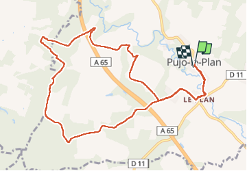
Tocht Stappen van 12,9 km beschikbaar op Nieuw-Aquitanië, Landes, Pujo-le-Plan. Deze tocht wordt voorgesteld door papiou.
Beschrijving
rdv mairie et dos à celle ci partir à gauche et suivre l'appli pour un circuit par route, près des champs et en forêt. Superbe circuit proposé par le Comité des fêtes de Pujo.
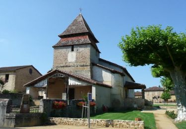
pour faire 10km, le départ peut se faire à l'église de Le Plan
Plaatsbepaling
Land:
France
Regio :
Nieuw-Aquitanië
Departement/Provincie :
Landes
Gemeente :
Pujo-le-Plan
Locatie:
Unknown
Vertrek:(Dec)
Vertrek:(UTM)
714379 ; 4860027 (30T) N.
Opmerkingen
Wandeltochten in de omgeving
![Tocht Te voet Villeneuve-de-Marsan - Petite Randonnée Villeneuve - Photo](https://media.geolcdn.com/t/375/260/9a1502fb-95da-4a41-b70c-7efd1ad3de51.jpeg&format=jpg&maxdim=2)
![Te voet Te voet](https://static1.geolcdn.com/sitytour/trail-icons/100.png)
Petite Randonnée Villeneuve
Te voet
Gemakkelijk
Villeneuve-de-Marsan,
Nieuw-Aquitanië,
Landes,
France
![](/images/other/stat-length.png)
6,1 km | 7,1 km-effort
1h 36min
![](https://static1.geolcdn.com/siteimages/upload/files/16400158638029165_repeat_loop_refresh_sync_direction_icon.png)
Ja
![Tocht Mountainbike Bougue - De Bougues à Gaillères - Photo](https://media.geolcdn.com/t/375/260/ext.jpg?maxdim=2&url=https%3A%2F%2Fservices.sitytrail.com%2FGeolivesWS%2FDownloadMedia.ashx%3FTrailID%3D102800%26Media%3D3962_1.jpg)
![Mountainbike Mountainbike](https://static1.geolcdn.com/sitytour/trail-icons/202.png)
De Bougues à Gaillères
Mountainbike
Medium
Bougue,
Nieuw-Aquitanië,
Landes,
France
![](/images/other/stat-length.png)
34 km | 39 km-effort
3h 0min
![](https://static1.geolcdn.com/siteimages/upload/files/16400158638029165_repeat_loop_refresh_sync_direction_icon.png)
Ja
![Tocht Stappen Villeneuve-de-Marsan - Villeneuve, le midou. trace faite - Photo](https://media.geolcdn.com/t/375/260/ext.jpg?maxdim=2&url=https%3A%2F%2Fstatic1.geolcdn.com%2Fsiteimages%2Fupload%2Ffiles%2F1553511878bg_sport_marche.png)
![Stappen Stappen](https://static1.geolcdn.com/sitytour/trail-icons/101.png)
Villeneuve, le midou. trace faite
Stappen
Gemakkelijk
Villeneuve-de-Marsan,
Nieuw-Aquitanië,
Landes,
France
![](/images/other/stat-length.png)
7,6 km | 8,7 km-effort
1h 34min
![](https://static1.geolcdn.com/siteimages/upload/files/16400158638029165_repeat_loop_refresh_sync_direction_icon.png)
Ja
![Tocht Stappen Saint-Gein - Saint Gein - Photo](https://media.geolcdn.com/t/375/260/ext.jpg?maxdim=2&url=https%3A%2F%2Fstatic1.geolcdn.com%2Fsiteimages%2Fupload%2Ffiles%2F1553511878bg_sport_marche.png)
![Stappen Stappen](https://static1.geolcdn.com/sitytour/trail-icons/101.png)
Saint Gein
Stappen
Moeilijk
Saint-Gein,
Nieuw-Aquitanië,
Landes,
France
![](/images/other/stat-length.png)
10,4 km | 12,2 km-effort
2h 39min
![](https://static1.geolcdn.com/siteimages/upload/files/16400158638029165_repeat_loop_refresh_sync_direction_icon.png)
Ja
![Tocht Stappen Maurrin - Maurin - Photo](https://media.geolcdn.com/t/375/260/ext.jpg?maxdim=2&url=https%3A%2F%2Fstatic1.geolcdn.com%2Fsiteimages%2Fupload%2Ffiles%2F1553511878bg_sport_marche.png)
![Stappen Stappen](https://static1.geolcdn.com/sitytour/trail-icons/101.png)
![Tocht Stappen Bougue - Bougue laglorieuse 2022 - Photo](https://media.geolcdn.com/t/375/260/ext.jpg?maxdim=2&url=https%3A%2F%2Fstatic1.geolcdn.com%2Fsiteimages%2Fupload%2Ffiles%2F1553511878bg_sport_marche.png)
![Stappen Stappen](https://static1.geolcdn.com/sitytour/trail-icons/101.png)
Bougue laglorieuse 2022
Stappen
Heel gemakkelijk
Bougue,
Nieuw-Aquitanië,
Landes,
France
![](/images/other/stat-length.png)
10,7 km | 12,5 km-effort
2h 22min
![](https://static1.geolcdn.com/siteimages/upload/files/16400158638029165_repeat_loop_refresh_sync_direction_icon.png)
Ja
![Tocht Stappen Hontanx - Hontanx - Photo](https://media.geolcdn.com/t/375/260/ext.jpg?maxdim=2&url=https%3A%2F%2Fstatic1.geolcdn.com%2Fsiteimages%2Fupload%2Ffiles%2F1553511878bg_sport_marche.png)
![Stappen Stappen](https://static1.geolcdn.com/sitytour/trail-icons/101.png)
Hontanx
Stappen
Moeilijk
Hontanx,
Nieuw-Aquitanië,
Landes,
France
![](/images/other/stat-length.png)
11,9 km | 13,7 km-effort
2h 33min
![](https://static1.geolcdn.com/siteimages/upload/files/16400158638029165_repeat_loop_refresh_sync_direction_icon.png)
Ja
![Tocht Fietstoerisme Villeneuve-de-Marsan - Villeneuve de Marsan - Circuit de l'Armagnac - Photo](https://media.geolcdn.com/t/375/260/ext.jpg?maxdim=2&url=https%3A%2F%2Fstatic1.geolcdn.com%2Fsiteimages%2Fupload%2Ffiles%2F1524743154velo.jpg)
![Fietstoerisme Fietstoerisme](https://static1.geolcdn.com/sitytour/trail-icons/204.png)
Villeneuve de Marsan - Circuit de l'Armagnac
Fietstoerisme
Medium
Villeneuve-de-Marsan,
Nieuw-Aquitanië,
Landes,
France
![](/images/other/stat-length.png)
63 km | 72 km-effort
Onbekend
![](https://static1.geolcdn.com/siteimages/upload/files/16400158638029165_repeat_loop_refresh_sync_direction_icon.png)
Ja
![Tocht Stappen Bougue - boucle Bougue Laglorieuse - Photo](https://media.geolcdn.com/t/375/260/ext.jpg?maxdim=2&url=https%3A%2F%2Fstatic1.geolcdn.com%2Fsiteimages%2Fupload%2Ffiles%2F1553511878bg_sport_marche.png)
![Stappen Stappen](https://static1.geolcdn.com/sitytour/trail-icons/101.png)
boucle Bougue Laglorieuse
Stappen
Heel gemakkelijk
Bougue,
Nieuw-Aquitanië,
Landes,
France
![](/images/other/stat-length.png)
10,5 km | 12,4 km-effort
2h 18min
![](https://static1.geolcdn.com/siteimages/upload/files/16400158638029165_repeat_loop_refresh_sync_direction_icon.png)
Ja