![](/images/other/stat-length.png)
![Tocht Stappen Urdos - Borce - Sentier de la traverse - Photo](https://media.geolcdn.com/t/1900/400/23d61935-9145-44ea-a032-65bf58f12017.jpg&format=pjpeg&maxdim=2)
Borce - Sentier de la traverse
bedous
Gebruiker
![Lengte](/images/other/stat-length.png)
Lengte
7,2 km
![Max. hoogte](https://static1.geolcdn.com/siteimages/upload/files/1508320355ic_sort_altitude_max_24dp.png)
Max. hoogte
1317 m
![Positief hoogteverschil](https://static1.geolcdn.com/siteimages/upload/files/1508320355ic_sort_den_pos_24dp.png)
Positief hoogteverschil
593 m
![Km-Effort](/images/other/stat-length.png)
Km-Effort
15,1 km
![Min. hoogte](https://static1.geolcdn.com/siteimages/upload/files/1508320355ic_sort_altitude_min_24dp.png)
Min. hoogte
775 m
![Negatief hoogteverschil](https://static1.geolcdn.com/siteimages/upload/files/1508320355ic_sort_den_neg_24dp.png)
Negatief hoogteverschil
591 m
![Boucle](https://static1.geolcdn.com/siteimages/upload/files/16400158638029165_repeat_loop_refresh_sync_direction_icon.png)
Boucle
Ja
Datum van aanmaak :
2024-08-22 05:13:12.404
Laatste wijziging :
2024-08-22 15:58:31.897
![Stappen](https://static1.geolcdn.com/sitytour/trail-icons/101.png)
4h00
Moeilijkheid : Moeilijk
![Scan deze QR-code om de tocht te openen in de SityTrail-applicatie](https://capi.geolives.com/qq0zvz2zws4bq2lad0pu/sitytour/trails/4164329/qr.png?size=200)
Gratisgps-wandelapplicatie
Over ons
Tocht Stappen van 7,2 km beschikbaar op Nieuw-Aquitanië, Pyrénées-Atlantiques, Urdos. Deze tocht wordt voorgesteld door bedous.
Beschrijving
Sentier assez difficile (pentes raides et caillouteuses) pour atteindre l'antenne relais qui surplombe la vallée au dessus du fort du Portalet, puis boucle qui redescendra sur Borce. Circuit en grande partie ombragé.
Plaatsbepaling
Land:
France
Regio :
Nieuw-Aquitanië
Departement/Provincie :
Pyrénées-Atlantiques
Gemeente :
Urdos
Locatie:
Unknown
Vertrek:(Dec)
Vertrek:(UTM)
699764 ; 4749667 (30T) N.
Opmerkingen
Wandeltochten in de omgeving
![Tocht Sneeuwschoenen Borce - Refuge et lac d’Arlet - Photo](https://media.geolcdn.com/t/375/260/a5cc868f-a627-4b9d-939f-bef0d8443aec.jpg&format=jpg&maxdim=2)
![Sneeuwschoenen Sneeuwschoenen](https://static1.geolcdn.com/sitytour/trail-icons/504.png)
Refuge et lac d’Arlet
Sneeuwschoenen
Medium
(1)
Borce,
Nieuw-Aquitanië,
Pyrénées-Atlantiques,
France
![](/images/other/stat-length.png)
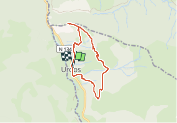
16,9 km | 30 km-effort
6h 49min
![](https://static1.geolcdn.com/siteimages/upload/files/16400158638029165_repeat_loop_refresh_sync_direction_icon.png)
Ja
![Tocht Stappen Etsaut - CHEMIN DE LA MATURE - Photo](https://media.geolcdn.com/t/375/260/ext.jpg?maxdim=2&url=https%3A%2F%2Fservices.sitytrail.com%2FGeolivesWS%2FDownloadMedia.ashx%3FTrailID%3D330343%26Media%3Dfix__20140727111121.jpg)
![Stappen Stappen](https://static1.geolcdn.com/sitytour/trail-icons/101.png)
CHEMIN DE LA MATURE
Stappen
Medium
(2)
Etsaut,
Nieuw-Aquitanië,
Pyrénées-Atlantiques,
France
![](/images/other/stat-length.png)
8,8 km | 18,6 km-effort
3h 25min
![](https://static1.geolcdn.com/siteimages/upload/files/16400158638029165_repeat_loop_refresh_sync_direction_icon.png)
Ja
![Tocht Stappen Etsaut - Chemin de la Mâture en vallée d'Aspe - Photo](https://media.geolcdn.com/t/375/260/ext.jpg?maxdim=2&url=https%3A%2F%2Fservices.sitytrail.com%2FGeolivesWS%2FDownloadMedia.ashx%3FTrailID%3D109346%26Media%3D3629_1.jpg)
![Stappen Stappen](https://static1.geolcdn.com/sitytour/trail-icons/101.png)
Chemin de la Mâture en vallée d'Aspe
Stappen
Moeilijk
(1)
Etsaut,
Nieuw-Aquitanië,
Pyrénées-Atlantiques,
France
![](/images/other/stat-length.png)
7,5 km | 16,8 km-effort
4h 0min
![](https://static1.geolcdn.com/siteimages/upload/files/16400158638029165_repeat_loop_refresh_sync_direction_icon.png)
Ja
![Tocht Te voet Urdos - Tour Urdos - Bérat asp66 - Photo](https://media.geolcdn.com/t/375/260/6386a7ee-b394-4eb6-89b9-f6e5520be03f.jpeg&format=jpg&maxdim=2)
![Te voet Te voet](https://static1.geolcdn.com/sitytour/trail-icons/100.png)
Tour Urdos - Bérat asp66
Te voet
Gemakkelijk
Urdos,
Nieuw-Aquitanië,
Pyrénées-Atlantiques,
France
![](/images/other/stat-length.png)
4,4 km | 6,8 km-effort
1h 32min
![](https://static1.geolcdn.com/siteimages/upload/files/16400158638029165_repeat_loop_refresh_sync_direction_icon.png)
Ja
![Tocht Te voet Etsaut - Chemin de Beloute asp118 - Photo](https://media.geolcdn.com/t/375/260/c8c5e68c-6418-4f8e-ac8d-ca44ee2eda0b.jpeg&format=jpg&maxdim=2)
![Te voet Te voet](https://static1.geolcdn.com/sitytour/trail-icons/100.png)
Chemin de Beloute asp118
Te voet
Gemakkelijk
Etsaut,
Nieuw-Aquitanië,
Pyrénées-Atlantiques,
France
![](/images/other/stat-length.png)
3,1 km | 8,3 km-effort
1h 53min
![](https://static1.geolcdn.com/siteimages/upload/files/16400158638029165_repeat_loop_refresh_sync_direction_icon.png)
Neen
![Tocht Te voet Borce - Tour du Bialaa asp63 - Photo](https://media.geolcdn.com/t/375/260/72d81d64-2083-4baa-8df9-d1a4781bec11.jpeg&format=jpg&maxdim=2)
![Te voet Te voet](https://static1.geolcdn.com/sitytour/trail-icons/100.png)
Tour du Bialaa asp63
Te voet
Gemakkelijk
Borce,
Nieuw-Aquitanië,
Pyrénées-Atlantiques,
France
![](/images/other/stat-length.png)
3,7 km | 7,9 km-effort
1h 47min
![](https://static1.geolcdn.com/siteimages/upload/files/16400158638029165_repeat_loop_refresh_sync_direction_icon.png)
Neen
![Tocht Te voet Borce - Tour d'Ayriré par Udapet asp64 - Photo](https://media.geolcdn.com/t/375/260/66af5b82-374a-4112-a15b-d6f19aa92aa9.jpeg&format=jpg&maxdim=2)
![Te voet Te voet](https://static1.geolcdn.com/sitytour/trail-icons/100.png)
Tour d'Ayriré par Udapet asp64
Te voet
Gemakkelijk
Borce,
Nieuw-Aquitanië,
Pyrénées-Atlantiques,
France
![](/images/other/stat-length.png)
5,2 km | 13,2 km-effort
2h 59min
![](https://static1.geolcdn.com/siteimages/upload/files/16400158638029165_repeat_loop_refresh_sync_direction_icon.png)
Neen
![Tocht Te voet Borce - Sentier de Borce à Belonce PNP - Photo](https://media.geolcdn.com/t/375/260/c9dd0836-6811-4332-bdc7-4bfac8c4af11.jpeg&format=jpg&maxdim=2)
![Te voet Te voet](https://static1.geolcdn.com/sitytour/trail-icons/100.png)
Sentier de Borce à Belonce PNP
Te voet
Gemakkelijk
Borce,
Nieuw-Aquitanië,
Pyrénées-Atlantiques,
France
![](/images/other/stat-length.png)
6,4 km | 11,3 km-effort
2h 33min
![](https://static1.geolcdn.com/siteimages/upload/files/16400158638029165_repeat_loop_refresh_sync_direction_icon.png)
Neen
![Tocht Te voet Urdos - Sentier d'Urdos au Refuge de Larry PNP - Photo](https://media.geolcdn.com/t/375/260/6386a7ee-b394-4eb6-89b9-f6e5520be03f.jpeg&format=jpg&maxdim=2)
![Te voet Te voet](https://static1.geolcdn.com/sitytour/trail-icons/100.png)
Sentier d'Urdos au Refuge de Larry PNP
Te voet
Gemakkelijk
Urdos,
Nieuw-Aquitanië,
Pyrénées-Atlantiques,
France
![](/images/other/stat-length.png)
5,4 km | 14,9 km-effort
3h 23min
![](https://static1.geolcdn.com/siteimages/upload/files/16400158638029165_repeat_loop_refresh_sync_direction_icon.png)
Neen