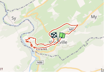
![](/images/other/stat-length.png)
![Tocht Stappen Ferrières - Balade à Vieuxville - Photo](https://media.geolcdn.com/t/1900/400/3d83d11a-36e5-49d1-95ba-0dc446a21709.jpg&format=pjpeg&maxdim=2)
Balade à Vieuxville
Desrumaux
Gebruiker GUIDE
![Lengte](/images/other/stat-length.png)
![Max. hoogte](https://static1.geolcdn.com/siteimages/upload/files/1508320355ic_sort_altitude_max_24dp.png)
![Positief hoogteverschil](https://static1.geolcdn.com/siteimages/upload/files/1508320355ic_sort_den_pos_24dp.png)
![Km-Effort](/images/other/stat-length.png)
![Min. hoogte](https://static1.geolcdn.com/siteimages/upload/files/1508320355ic_sort_altitude_min_24dp.png)
![Negatief hoogteverschil](https://static1.geolcdn.com/siteimages/upload/files/1508320355ic_sort_den_neg_24dp.png)
![Boucle](https://static1.geolcdn.com/siteimages/upload/files/16400158638029165_repeat_loop_refresh_sync_direction_icon.png)
![Stappen](https://static1.geolcdn.com/sitytour/trail-icons/101.png)
2h22
Moeilijkheid : Medium
![Scan deze QR-code om de tocht te openen in de SityTrail-applicatie](https://capi.geolives.com/qq0zvz2zws4bq2lad0pu/sitytour/trails/4161154/qr.png?size=200)
Gratisgps-wandelapplicatie
Over ons
Tocht Stappen van 7,7 km beschikbaar op Wallonië, Luik, Ferrières. Deze tocht wordt voorgesteld door Desrumaux.
Beschrijving
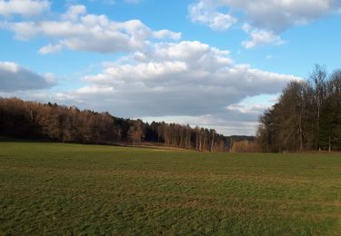
Très jolie balade au départ du village de Vieuxville dans l'entité de Ferrières en Province de Liège.
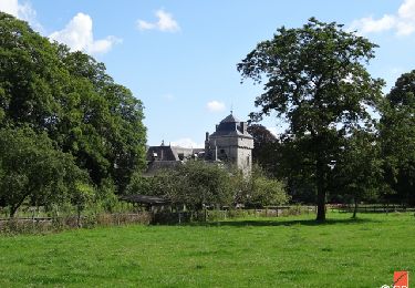
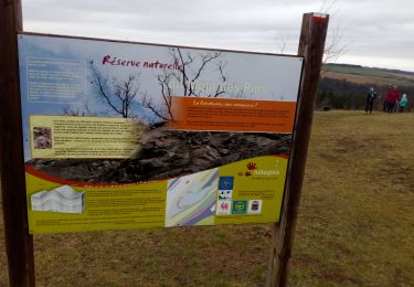
Le village de Vieuxville situé sur la rive droite de la Lembrée, un affluent de l’Ourthe ici toute proche, est très riche d’histoire, avec le château-fort de Logne, le cimetière mérovingien et sa chapelle romane, les fermes de la Bouverie et de Palogne.
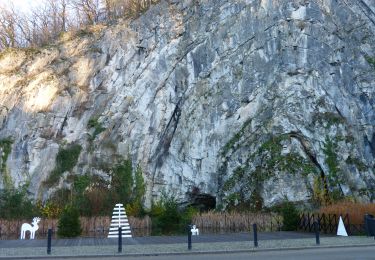
Site remarquable de l’Ourthe liégeoise, le château fort de Logne a toujours été le refuge naturel des habitants de la vallée. Perché au sommet d’un éperon rocheux creusé de cavernes, il offre une vue exceptionnelle sur la vallée et sur les crêtes de l’Ardenne.
Départ église de Vieuxville.
Plaatsbepaling
Opmerkingen
Wandeltochten in de omgeving
![Tocht Stappen Hamoir - RB-Lg-19_Hamoir - Photo](https://media.geolcdn.com/t/375/260/ext.jpg?maxdim=2&url=https%3A%2F%2Fservices.sitytrail.com%2FGeolivesWS%2FDownloadMedia.ashx%3FTrailID%3D400602%26Media%3Dc0745639-8ded-479e-9345-a8c68cd61e6a.jpg)
![Stappen Stappen](https://static1.geolcdn.com/sitytour/trail-icons/101.png)
Stappen
![](/images/other/stat-length.png)
![](https://static1.geolcdn.com/siteimages/upload/files/16400158638029165_repeat_loop_refresh_sync_direction_icon.png)
![Tocht Stappen Durbuy - RF-Lu-02 - Variante Ravel - Au fils de l'Ourthe : Barvaux - Photo](https://media.geolcdn.com/t/375/260/ext.jpg?maxdim=2&url=https%3A%2F%2Fstatic1.geolcdn.com%2Fsiteimages%2Fupload%2Ffiles%2F1553511878bg_sport_marche.png)
![Stappen Stappen](https://static1.geolcdn.com/sitytour/trail-icons/101.png)
Stappen
![](/images/other/stat-length.png)
![](https://static1.geolcdn.com/siteimages/upload/files/16400158638029165_repeat_loop_refresh_sync_direction_icon.png)
![Tocht Stappen Durbuy - Balade à Bomal sur Ourthe - Photo](https://media.geolcdn.com/t/375/260/5741dd62-7ff1-40d2-b9aa-0e0aed97da9a.jpg&format=jpg&maxdim=2)
![Stappen Stappen](https://static1.geolcdn.com/sitytour/trail-icons/101.png)
Stappen
![](/images/other/stat-length.png)
![](https://static1.geolcdn.com/siteimages/upload/files/16400158638029165_repeat_loop_refresh_sync_direction_icon.png)
![Tocht Stappen Hamoir - HAMOIR (Vallée du Neblon) - Photo](https://media.geolcdn.com/t/375/260/bd133f9f-5595-47e8-88c0-4d09e83d3ba8.jpg&format=jpg&maxdim=2)
![Stappen Stappen](https://static1.geolcdn.com/sitytour/trail-icons/101.png)
Stappen
![](/images/other/stat-length.png)
![](https://static1.geolcdn.com/siteimages/upload/files/16400158638029165_repeat_loop_refresh_sync_direction_icon.png)
![Tocht Stappen Ferrières - GG-Lu-15_Sy - Barvaux - Photo](https://media.geolcdn.com/t/375/260/4cf6fb9a-77d5-4c51-bb72-4b6ca6a27202.jpg&format=jpg&maxdim=2)
![Stappen Stappen](https://static1.geolcdn.com/sitytour/trail-icons/101.png)
Stappen
![](/images/other/stat-length.png)
![](https://static1.geolcdn.com/siteimages/upload/files/16400158638029165_repeat_loop_refresh_sync_direction_icon.png)
![Stappen Stappen](https://static1.geolcdn.com/sitytour/trail-icons/101.png)
Stappen
![](/images/other/stat-length.png)
![](https://static1.geolcdn.com/siteimages/upload/files/16400158638029165_repeat_loop_refresh_sync_direction_icon.png)
![Tocht Stappen Durbuy - Barvaux - Photo](https://media.geolcdn.com/t/375/260/e722c297-c1c8-4c60-9c09-cdc0f3170e8a.jpg&format=jpg&maxdim=2)
![Stappen Stappen](https://static1.geolcdn.com/sitytour/trail-icons/101.png)
Stappen
![](/images/other/stat-length.png)
![](https://static1.geolcdn.com/siteimages/upload/files/16400158638029165_repeat_loop_refresh_sync_direction_icon.png)
![Tocht Stappen Hamoir - Hamoir - Sy - Les Crêtes - Photo](https://media.geolcdn.com/t/375/260/2cd3e10e-e069-4884-9433-cbc8b49962aa.jpg&format=jpg&maxdim=2)
![Stappen Stappen](https://static1.geolcdn.com/sitytour/trail-icons/101.png)
Stappen
![](/images/other/stat-length.png)
![](https://static1.geolcdn.com/siteimages/upload/files/16400158638029165_repeat_loop_refresh_sync_direction_icon.png)
![Tocht Stappen Durbuy - Sur les dessus de Bomal - Photo](https://media.geolcdn.com/t/375/260/95859345-d2d2-447d-9601-6791094bfa98.jpg&format=jpg&maxdim=2)
![Stappen Stappen](https://static1.geolcdn.com/sitytour/trail-icons/101.png)
Stappen
![](/images/other/stat-length.png)
![](https://static1.geolcdn.com/siteimages/upload/files/16400158638029165_repeat_loop_refresh_sync_direction_icon.png)