Tocht Stappen Saint-Germain-en-Laye - terr11 - Photo
 ROBERT-MICHEL
ROBERT-MICHEL

Gebruiker

© OpenStreetMap contributors
Lengte
Lengte
1,1 km
Max. hoogte
Max. hoogte
86 m
Positief hoogteverschil
19 m
Km-Effort
Km-Effort  
1,3 km
Min. hoogte
Min. hoogte
65 m
Negatief hoogteverschil
6 m
Boucle
Boucle
Neen
Datum van aanmaak :
2024-08-17 10:11:48.283
Laatste wijziging :
2024-08-17 10:51:23.862

(0 Bericht)

Stappen
Stappen
39m
Moeilijkheid : Gemakkelijk

Scan deze QR-code om de tocht te openen in de SityTrail-applicatie

Gratisgps-wandelapplicatie

Logo SityTrail SityTrail

IGN / Geografische instituten

SityTrail uit de App Store downloaden SityTrail uit Google Play downloaden

Logo SityTrail SityTrail World

De wereld gaat voor u open

SityTrail uit de App Store downloaden SityTrail uit Google Play downloaden SityTrail op Huawei AppGallery downloaden

Over ons

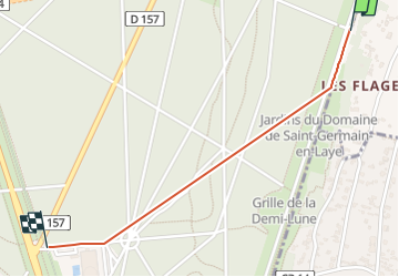
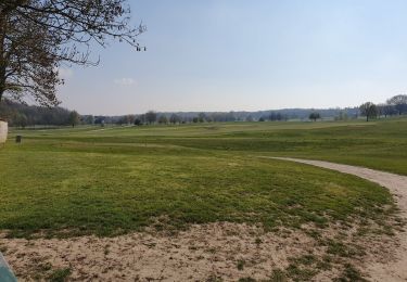
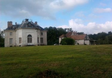
Tocht Stappen van 1,1 km beschikbaar op Île-de-France, Yvelines, Saint-Germain-en-Laye. Deze tocht wordt voorgesteld door ROBERT-MICHEL.

Hoogteprofiel

Plaatsbepaling

Land:
France
Regio :
Île-de-France
Departement/Provincie :
Yvelines
Gemeente :
Saint-Germain-en-Laye
Locatie:
Saint-Germain-en-Laye
Vertrek:(UTM)
434458 ; 5417876 (31U) N.

Wandeltochten in de omgeving

Tocht Stappen Rueil-Malmaison - St Germain en Laye - Rueil Malmaison 28 km Inversee - Photo
Stappen
GUIDE
chessyca

Stappen

Gemakkelijk
(1)
Rueil-Malmaison, Île-de-France, Hauts-de-Seine, France
28 km | 32 km-effort
6h 0min
Neen
Tocht Stappen Saint-Germain-en-Laye - GRP CV-IDF 2023 - Photo
Stappen
clalaur

Stappen

Zeer moeilijk
(1)
Saint-Germain-en-Laye, Île-de-France, Yvelines, France
16,5 km | 19,1 km-effort
4h 21min
Neen
Tocht Stappen L'Étang-la-Ville - GRP CV-IDF 2023 - Photo
Stappen
clalaur

Stappen

Moeilijk
(1)
L'Étang-la-Ville, Île-de-France, Yvelines, France
10,7 km | 13,7 km-effort
3h 6min
Neen
Tocht Stappen Saint-Germain-en-Laye - circuit MA 271019  - Photo
Stappen
runarlejou

Stappen

Heel gemakkelijk
(1)
Saint-Germain-en-Laye, Île-de-France, Yvelines, France
4,7 km | 5,2 km-effort
1h 3min
Ja
Tocht Stappen Chambourcy - Ballade autour du golf de Chambourcy - Photo
Stappen
phimar_2612

Stappen

Medium
(1)
Chambourcy, Île-de-France, Yvelines, France
8,5 km | 10,6 km-effort
1h 55min
Ja
Tocht Stappen Saint-Germain-en-Laye - D'Achères Grand Cormier à Maison Laffitte - Photo
Stappen
tracegps

Stappen

Medium
(1)
Saint-Germain-en-Laye, Île-de-France, Yvelines, France
12,9 km | 14,4 km-effort
3h 0min
Neen
Tocht Stappen Marly-le-Roi - Boucle 25 km Marly le Roi - Chambourcy - Photo
Stappen
GUIDE
chessyca

Stappen

Medium
Marly-le-Roi, Île-de-France, Yvelines, France
25 km | 32 km-effort
7h 15min
Ja
Tocht Stappen Le Mesnil-le-Roi - RS 5 km porte chene corbeau - Photo
Stappen
patb54

Stappen

Gemakkelijk
(1)
Le Mesnil-le-Roi, Île-de-France, Yvelines, France
5,2 km | 5,8 km-effort
1h 18min
Ja
Tocht Te voet Rueil-Malmaison - SityTrail - 3850997 - rando-chatou (1) - Photo
Te voet
GUIDE
chessyca

Te voet

Medium
Rueil-Malmaison, Île-de-France, Hauts-de-Seine, France
32 km | 37 km-effort
8h 22min
Neen


Sluiten
Mijn abonnementen