Tocht Stappen Rantigny - Rantigny_La croix de VauxTrace GPS simplifiée_9,0 km - Photo

Rantigny_La croix de VauxTrace GPS simplifiée_9,0 km

 Pousscailleux
Pousscailleux

Gebruiker

© OpenStreetMap contributors
Lengte
Lengte
8,9 km
Max. hoogte
Max. hoogte
127 m
Positief hoogteverschil
126 m
Km-Effort
Km-Effort  
10,6 km
Min. hoogte
Min. hoogte
50 m
Negatief hoogteverschil
128 m
Boucle
Boucle
Ja
Datum van aanmaak :
2015-05-03 00:00:00.0
Laatste wijziging :
2015-05-03 00:00:00.0

(0 Bericht)

Stappen
Stappen
2h12
Moeilijkheid : Gemakkelijk

Scan deze QR-code om de tocht te openen in de SityTrail-applicatie

Gratisgps-wandelapplicatie

Logo SityTrail SityTrail

IGN / Geografische instituten

SityTrail uit de App Store downloaden SityTrail uit Google Play downloaden

Logo SityTrail SityTrail World

De wereld gaat voor u open

SityTrail uit de App Store downloaden SityTrail uit Google Play downloaden SityTrail op Huawei AppGallery downloaden

Over ons

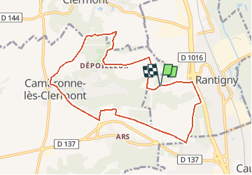
Tocht Stappen van 8,9 km beschikbaar op Hauts-de-France, Oise, Rantigny. Deze tocht wordt voorgesteld door Pousscailleux.

Beschrijving

Départ du parking du nouveau cimetière de Rantigny coordonnées GPS : N49°19'48.14"/E002°25'35.37"

Hoogteprofiel

Plaatsbepaling

Land:
France
Regio :
Hauts-de-France
Departement/Provincie :
Oise
Gemeente :
Rantigny
Locatie:
Unknown
Vertrek:(Dec)
Vertrek:(UTM)
458323 ; 5464301 (31U) N.

Wandeltochten in de omgeving

Tocht Stappen Bailleval - Rando cavée des Vaches - Photo
Stappen
Laigneville159-

Stappen

Gemakkelijk
Bailleval, Hauts-de-France, Oise, France
9,5 km | 11,6 km-effort
2h 49min
Ja
Tocht Stappen Verderonne - Randonnée de Rosoy à Verderonne - Photo
Stappen
tracegps

Stappen

Medium
Verderonne, Hauts-de-France, Oise, France
8,3 km | 9,9 km-effort
1h 30min
Ja
Tocht Stappen Breuil-le-Sec - 2024 07 27 - Photo
Stappen
ptimi

Stappen

Gemakkelijk
Breuil-le-Sec, Hauts-de-France, Oise, France
16,3 km | 21 km-effort
4h 0min
Ja
Tocht Stappen Rantigny - Vaux Cambrone - Photo
Stappen
Laigneville159-

Stappen

Rantigny, Hauts-de-France, Oise, France
8 km | 9,9 km-effort
2h 27min
Ja
Tocht Stappen Laigneville - Laigneville-Barisseuse 8k2 - Photo
Stappen
Laigneville159-

Stappen

Medium
Laigneville, Hauts-de-France, Oise, France
8,2 km | 9,7 km-effort
2h 11min
Ja
Tocht Elektrische fiets Breuil-le-Sec - 2023 12 03 - Photo
Elektrische fiets
ptimi

Elektrische fiets

Medium
Breuil-le-Sec, Hauts-de-France, Oise, France
38 km | 51 km-effort
3h 27min
Ja
Tocht Elektrische fiets Breuil-le-Sec - 2022 10 29 - Photo
Elektrische fiets
ptimi

Elektrische fiets

Medium
Breuil-le-Sec, Hauts-de-France, Oise, France
47 km | 57 km-effort
4h 47min
Ja
Tocht Elektrische fiets Breuil-le-Sec - 2022 10 08  - Photo
Elektrische fiets
ptimi

Elektrische fiets

Gemakkelijk
Breuil-le-Sec, Hauts-de-France, Oise, France
29 km | 36 km-effort
3h 21min
Ja
Tocht sport Monchy-Saint-Éloi - 2022-09-28_13h36m37_<CAC9XJQ5buBJim13UVmX+3WM3tvG2H9PncH-espriqxQdtYHG3Q@mailgmailcom>_chedeville-9kmsgpxchedeville-9kms - Photo
sport
Marc ROUSSELOT

sport

Heel gemakkelijk
Monchy-Saint-Éloi, Hauts-de-France, Oise, France
8 km | 9,5 km-effort
Onbekend
Ja


Sluiten
Mijn abonnementen