![](/images/other/stat-length.png)
![Tocht Stappen Celles - CELLES l'étang et l'église - Photo](https://media.geolcdn.com/t/1900/400/ext.pjpeg?maxdim=2&url=https%3A%2F%2Fstatic1.geolcdn.com%2Fsiteimages%2Fupload%2Ffiles%2F1553511878bg_sport_marche.png)
CELLES l'étang et l'église
ehalle8544
Gebruiker
![Lengte](/images/other/stat-length.png)
Lengte
7,2 km
![Max. hoogte](https://static1.geolcdn.com/siteimages/upload/files/1508320355ic_sort_altitude_max_24dp.png)
Max. hoogte
151 m
![Positief hoogteverschil](https://static1.geolcdn.com/siteimages/upload/files/1508320355ic_sort_den_pos_24dp.png)
Positief hoogteverschil
135 m
![Km-Effort](/images/other/stat-length.png)
Km-Effort
9 km
![Min. hoogte](https://static1.geolcdn.com/siteimages/upload/files/1508320355ic_sort_altitude_min_24dp.png)
Min. hoogte
85 m
![Negatief hoogteverschil](https://static1.geolcdn.com/siteimages/upload/files/1508320355ic_sort_den_neg_24dp.png)
Negatief hoogteverschil
123 m
![Boucle](https://static1.geolcdn.com/siteimages/upload/files/16400158638029165_repeat_loop_refresh_sync_direction_icon.png)
Boucle
Ja
Datum van aanmaak :
2024-08-06 12:57:49.825
Laatste wijziging :
2024-08-06 13:02:58.907
![Stappen](https://static1.geolcdn.com/sitytour/trail-icons/101.png)
2h02
Moeilijkheid : Medium
![Scan deze QR-code om de tocht te openen in de SityTrail-applicatie](https://capi.geolives.com/qq0zvz2zws4bq2lad0pu/sitytour/trails/4146471/qr.png?size=200)
Gratisgps-wandelapplicatie
Over ons
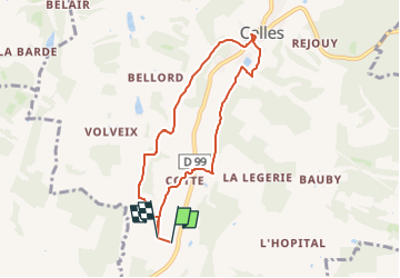
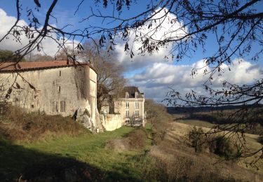
Tocht Stappen van 7,2 km beschikbaar op Nieuw-Aquitanië, Dordogne, Celles. Deze tocht wordt voorgesteld door ehalle8544.
Beschrijving
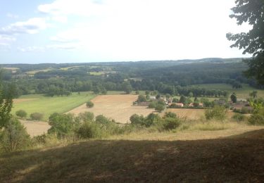
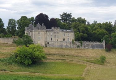
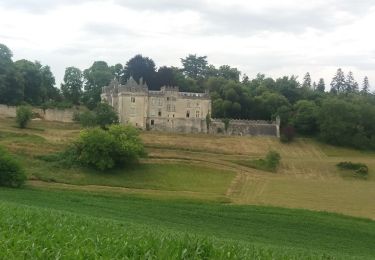
Du hameau monrepos au centre du village de CELLES petite balade que j classe quant même en difficulté moyenne. Mais sympa pour les bons marcheurs au milieu des champs de maïs et de tournesols
Plaatsbepaling
Land:
France
Regio :
Nieuw-Aquitanië
Departement/Provincie :
Dordogne
Gemeente :
Celles
Locatie:
Unknown
Vertrek:(Dec)
Vertrek:(UTM)
296030 ; 5016749 (31T) N.
Opmerkingen
Wandeltochten in de omgeving
![Tocht Stappen Saint-Victor - 24 Boucle de Saint-Victor - Photo](https://media.geolcdn.com/t/375/260/ext.jpg?maxdim=2&url=https%3A%2F%2Fservices.sitytrail.com%2FGeolivesWS%2FDownloadMedia.ashx%3FTrailID%3D611039%26Media%3D20160808165131.jpg)
![Stappen Stappen](https://static1.geolcdn.com/sitytour/trail-icons/101.png)
24 Boucle de Saint-Victor
Stappen
Gemakkelijk
(1)
Saint-Victor,
Nieuw-Aquitanië,
Dordogne,
France
![](/images/other/stat-length.png)
11,7 km | 16,1 km-effort
3h 24min
![](https://static1.geolcdn.com/siteimages/upload/files/16400158638029165_repeat_loop_refresh_sync_direction_icon.png)
Ja
![Tocht Stappen Celles - Boucle de Celles - Photo](https://media.geolcdn.com/t/375/260/42dfacb0-24d9-4201-94af-6756333c6246.jpg&format=jpg&maxdim=2)
![Stappen Stappen](https://static1.geolcdn.com/sitytour/trail-icons/101.png)
Boucle de Celles
Stappen
Gemakkelijk
(1)
Celles,
Nieuw-Aquitanië,
Dordogne,
France
![](/images/other/stat-length.png)
12,8 km | 16,4 km-effort
3h 10min
![](https://static1.geolcdn.com/siteimages/upload/files/16400158638029165_repeat_loop_refresh_sync_direction_icon.png)
Ja
![Tocht Stappen Celles - boucle celles - Photo](https://media.geolcdn.com/t/375/260/800fe37f-eb51-4b84-a21b-f7c13895188c.jpg&format=jpg&maxdim=2)
![Stappen Stappen](https://static1.geolcdn.com/sitytour/trail-icons/101.png)
boucle celles
Stappen
Gemakkelijk
(1)
Celles,
Nieuw-Aquitanië,
Dordogne,
France
![](/images/other/stat-length.png)
13 km | 16,7 km-effort
3h 6min
![](https://static1.geolcdn.com/siteimages/upload/files/16400158638029165_repeat_loop_refresh_sync_direction_icon.png)
Ja
![Tocht Stappen Celles - 24 Celles - Photo](https://media.geolcdn.com/t/375/260/ext.jpg?maxdim=2&url=https%3A%2F%2Fservices.sitytrail.com%2FGeolivesWS%2FDownloadMedia.ashx%3FTrailID%3D684752%26Media%3D20170114154521.jpg)
![Stappen Stappen](https://static1.geolcdn.com/sitytour/trail-icons/101.png)
24 Celles
Stappen
Gemakkelijk
Celles,
Nieuw-Aquitanië,
Dordogne,
France
![](/images/other/stat-length.png)
13,2 km | 16,8 km-effort
3h 34min
![](https://static1.geolcdn.com/siteimages/upload/files/16400158638029165_repeat_loop_refresh_sync_direction_icon.png)
Ja
![Tocht Te voet Celles - Celles Le lavoir - Photo](https://media.geolcdn.com/t/375/260/ext.jpg?maxdim=2&url=https%3A%2F%2Fstatic1.geolcdn.com%2Fsiteimages%2Fupload%2Ffiles%2F1545311037marcheuse_200dpi.jpg)
![Te voet Te voet](https://static1.geolcdn.com/sitytour/trail-icons/100.png)
Celles Le lavoir
Te voet
Gemakkelijk
(1)
Celles,
Nieuw-Aquitanië,
Dordogne,
France
![](/images/other/stat-length.png)
11,5 km | 14,7 km-effort
3h 20min
![](https://static1.geolcdn.com/siteimages/upload/files/16400158638029165_repeat_loop_refresh_sync_direction_icon.png)
Ja
![Tocht Te voet Celles - Celles La Tournevalade - Photo](https://media.geolcdn.com/t/375/260/ext.jpg?maxdim=2&url=https%3A%2F%2Fstatic1.geolcdn.com%2Fsiteimages%2Fupload%2Ffiles%2F1545311037marcheuse_200dpi.jpg)
![Te voet Te voet](https://static1.geolcdn.com/sitytour/trail-icons/100.png)
Celles La Tournevalade
Te voet
Gemakkelijk
Celles,
Nieuw-Aquitanië,
Dordogne,
France
![](/images/other/stat-length.png)
11,9 km | 15,1 km-effort
3h 25min
![](https://static1.geolcdn.com/siteimages/upload/files/16400158638029165_repeat_loop_refresh_sync_direction_icon.png)
Ja
![Tocht Stappen Saint-Méard-de-Drône - boucle saint meard sur dronne - Photo](https://media.geolcdn.com/t/375/260/ext.jpg?maxdim=2&url=https%3A%2F%2Fstatic1.geolcdn.com%2Fsiteimages%2Fupload%2Ffiles%2F1553511878bg_sport_marche.png)
![Stappen Stappen](https://static1.geolcdn.com/sitytour/trail-icons/101.png)
boucle saint meard sur dronne
Stappen
Gemakkelijk
Saint-Méard-de-Drône,
Nieuw-Aquitanië,
Dordogne,
France
![](/images/other/stat-length.png)
10,5 km | 13,5 km-effort
2h 38min
![](https://static1.geolcdn.com/siteimages/upload/files/16400158638029165_repeat_loop_refresh_sync_direction_icon.png)
Ja
![Tocht Stappen Saint-Méard-de-Drône - St Méard de Drône - Photo](https://media.geolcdn.com/t/375/260/ext.jpg?maxdim=2&url=https%3A%2F%2Fstatic1.geolcdn.com%2Fsiteimages%2Fupload%2Ffiles%2F1553511878bg_sport_marche.png)
![Stappen Stappen](https://static1.geolcdn.com/sitytour/trail-icons/101.png)
St Méard de Drône
Stappen
Heel gemakkelijk
Saint-Méard-de-Drône,
Nieuw-Aquitanië,
Dordogne,
France
![](/images/other/stat-length.png)
10,6 km | 13,5 km-effort
2h 55min
![](https://static1.geolcdn.com/siteimages/upload/files/16400158638029165_repeat_loop_refresh_sync_direction_icon.png)
Ja
![Tocht Stappen Douchapt - boucle des fontaines - Photo](https://media.geolcdn.com/t/375/260/ext.jpg?maxdim=2&url=https%3A%2F%2Fstatic1.geolcdn.com%2Fsiteimages%2Fupload%2Ffiles%2F1553511878bg_sport_marche.png)
![Stappen Stappen](https://static1.geolcdn.com/sitytour/trail-icons/101.png)
boucle des fontaines
Stappen
Moeilijk
Douchapt,
Nieuw-Aquitanië,
Dordogne,
France
![](/images/other/stat-length.png)
10,6 km | 13,7 km-effort
2h 54min
![](https://static1.geolcdn.com/siteimages/upload/files/16400158638029165_repeat_loop_refresh_sync_direction_icon.png)
Ja