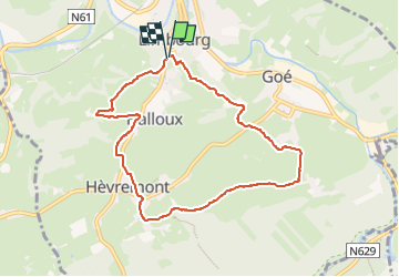
![](/images/other/stat-length.png)
![Tocht Stappen Limburg - Limbourg BIO 7,5 km le 29-07-2024 - Photo](https://media.geolcdn.com/t/1900/400/a581bc9f-942c-41a3-945d-f654ff7a1904.jpeg&format=pjpeg&maxdim=2)
Limbourg BIO 7,5 km le 29-07-2024
pierreh01
Gebruiker GUIDE
![Lengte](/images/other/stat-length.png)
![Max. hoogte](https://static1.geolcdn.com/siteimages/upload/files/1508320355ic_sort_altitude_max_24dp.png)
![Positief hoogteverschil](https://static1.geolcdn.com/siteimages/upload/files/1508320355ic_sort_den_pos_24dp.png)
![Km-Effort](/images/other/stat-length.png)
![Min. hoogte](https://static1.geolcdn.com/siteimages/upload/files/1508320355ic_sort_altitude_min_24dp.png)
![Negatief hoogteverschil](https://static1.geolcdn.com/siteimages/upload/files/1508320355ic_sort_den_neg_24dp.png)
![Boucle](https://static1.geolcdn.com/siteimages/upload/files/16400158638029165_repeat_loop_refresh_sync_direction_icon.png)
![Stappen](https://static1.geolcdn.com/sitytour/trail-icons/101.png)
2h05
Moeilijkheid : Medium
![Scan deze QR-code om de tocht te openen in de SityTrail-applicatie](https://capi.geolives.com/qq0zvz2zws4bq2lad0pu/sitytour/trails/4138590/qr.png?size=200)
Gratisgps-wandelapplicatie
Over ons
Tocht Stappen van 7,4 km beschikbaar op Wallonië, Luik, Limburg. Deze tocht wordt voorgesteld door pierreh01.
Beschrijving
Lundi 29 juillet 2024 : Balade hebdomadaire des "BIOS".
C'est sous un très très beau temps estival que nous nous sommes lancés à la suite de notre guide du jour André.
Quelques 22 "BIOS", 10♀, dont une enfant et 12♂ ont emprunté des routes parfois fréquentées par le trafic, des sentiers campagnards et des prairies.
Distance de 7,3 Km mesurée avec Komoot (Merci Henri).
Plaatsbepaling
Opmerkingen
Wandeltochten in de omgeving
![Tocht Stappen Limburg - RB-Lg-28_Limbourg - Photo](https://media.geolcdn.com/t/375/260/ext.jpg?maxdim=2&url=https%3A%2F%2Fservices.sitytrail.com%2FGeolivesWS%2FDownloadMedia.ashx%3FTrailID%3D402093%26Media%3D979895a6-f139-4f7a-8335-2e926c1b89c7.jpg)
![Stappen Stappen](https://static1.geolcdn.com/sitytour/trail-icons/101.png)
![Tocht Stappen Verviers - Grand vivier - Cossart - Photo](https://media.geolcdn.com/t/375/260/ext.jpg?maxdim=2&url=https%3A%2F%2Fstatic1.geolcdn.com%2Fsiteimages%2Fupload%2Ffiles%2F1553511878bg_sport_marche.png)
![Stappen Stappen](https://static1.geolcdn.com/sitytour/trail-icons/101.png)
Stappen
![](/images/other/stat-length.png)
![](https://static1.geolcdn.com/siteimages/upload/files/16400158638029165_repeat_loop_refresh_sync_direction_icon.png)
![Tocht Stappen Jalhay - La Gileppe - Bois de la Borchêne - Photo](https://media.geolcdn.com/t/375/260/e6c1c191-9060-48ef-8a65-d77cc5b69a34.jpg&format=jpg&maxdim=2)
![Stappen Stappen](https://static1.geolcdn.com/sitytour/trail-icons/101.png)
Stappen
![](/images/other/stat-length.png)
![](https://static1.geolcdn.com/siteimages/upload/files/16400158638029165_repeat_loop_refresh_sync_direction_icon.png)
![Tocht Stappen Baelen - Baelen - Eupen 🎄🎅 - Membach - Photo](https://media.geolcdn.com/t/375/260/d50227a7-424d-470e-90d5-87ebd384de36.jpg&format=jpg&maxdim=2)
![Stappen Stappen](https://static1.geolcdn.com/sitytour/trail-icons/101.png)
Stappen
![](/images/other/stat-length.png)
![](https://static1.geolcdn.com/siteimages/upload/files/16400158638029165_repeat_loop_refresh_sync_direction_icon.png)
![Tocht Stappen Baelen - La Montagne du Dragon - Photo](https://media.geolcdn.com/t/375/260/3a1bc634-7bf5-4748-bbb3-513b265a48b5.jpg&format=jpg&maxdim=2)
![Stappen Stappen](https://static1.geolcdn.com/sitytour/trail-icons/101.png)
Stappen
![](/images/other/stat-length.png)
![](https://static1.geolcdn.com/siteimages/upload/files/16400158638029165_repeat_loop_refresh_sync_direction_icon.png)
![Stappen Stappen](https://static1.geolcdn.com/sitytour/trail-icons/101.png)
Stappen
![](/images/other/stat-length.png)
![](https://static1.geolcdn.com/siteimages/upload/files/16400158638029165_repeat_loop_refresh_sync_direction_icon.png)
![Tocht Stappen Limburg - GG-Lg-11_Dolhain - Pepinster - Photo](https://media.geolcdn.com/t/375/260/9cf2c240-5913-4088-b4f6-6c0e1fae0233.jpg&format=jpg&maxdim=2)
![Stappen Stappen](https://static1.geolcdn.com/sitytour/trail-icons/101.png)
Stappen
![](/images/other/stat-length.png)
![](https://static1.geolcdn.com/siteimages/upload/files/16400158638029165_repeat_loop_refresh_sync_direction_icon.png)
![Tocht Stappen Limburg - 20200606 - Hèvremont 8 Km - Photo](https://media.geolcdn.com/t/375/260/8311f513-ce09-455a-b0ac-51a7423b07df.jpg&format=jpg&maxdim=2)
![Stappen Stappen](https://static1.geolcdn.com/sitytour/trail-icons/101.png)
Stappen
![](/images/other/stat-length.png)
![](https://static1.geolcdn.com/siteimages/upload/files/16400158638029165_repeat_loop_refresh_sync_direction_icon.png)
![Tocht Stappen Jalhay - La Gileppe - Photo](https://media.geolcdn.com/t/375/260/9374fc26-a93b-4b0a-b10a-5ceb74ed5a19.jpg&format=jpg&maxdim=2)
![Stappen Stappen](https://static1.geolcdn.com/sitytour/trail-icons/101.png)
Stappen
![](/images/other/stat-length.png)
![](https://static1.geolcdn.com/siteimages/upload/files/16400158638029165_repeat_loop_refresh_sync_direction_icon.png)