Tocht Mountainbike Mimet - Du Pilon au grand puech par l'étoile - Photo

Du Pilon au grand puech par l'étoile

 j13120
j13120

Gebruiker

© OpenStreetMap contributors
Lengte
Lengte
46 km
Max. hoogte
Max. hoogte
772 m
Positief hoogteverschil
1272 m
Km-Effort
Km-Effort  
63 km
Min. hoogte
Min. hoogte
278 m
Negatief hoogteverschil
1267 m
Boucle
Boucle
Ja
Datum van aanmaak :
2015-05-16 00:00:00.0
Laatste wijziging :
2015-05-16 00:00:00.0

(0 Bericht)

Mountainbike
Mountainbike
5h00
Moeilijkheid : Medium

Scan deze QR-code om de tocht te openen in de SityTrail-applicatie

Gratisgps-wandelapplicatie

Logo SityTrail SityTrail

IGN / Geografische instituten

SityTrail uit de App Store downloaden SityTrail uit Google Play downloaden

Logo SityTrail SityTrail World

De wereld gaat voor u open

SityTrail uit de App Store downloaden SityTrail uit Google Play downloaden SityTrail op Huawei AppGallery downloaden

Over ons

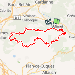
Tocht Mountainbike van 46 km beschikbaar op Provence-Alpes-Côte d'Azur, Bouches-du-Rhône, Mimet. Deze tocht wordt voorgesteld door j13120.

Beschrijving

Mimet, Boucle du pilon du roi au grand puech par l'étoile. Ballade sur chemins roulants, caillouteux sur certaine portion, mais sans difficulté particulière. Vue exceptionnelle sur la garrigue, on se croirait dans un livre de Pagnol.
Attention, qui dit garrigue, dit pas d'ombre, parcours à ne pas faire l'été, ou très tôt le matin.

Hoogteprofiel

POI's

POI Plan-de-Cuques - Relai de chasse - Photo
j13120
PLAN-DE-CUQUES 

Plaatsbepaling

Land:
France
Regio :
Provence-Alpes-Côte d'Azur
Departement/Provincie :
Bouches-du-Rhône
Gemeente :
Mimet
Locatie:
Unknown
Vertrek:(Dec)
Vertrek:(UTM)
701687 ; 4809448 (31T) N.

Wandeltochten in de omgeving

Tocht Stappen Allauch - Le tour des Grands Ubacs au départ de Pichauris - Photo
Stappen
Coqorico

Stappen

Gemakkelijk
(1)
Allauch, Provence-Alpes-Côte d'Azur, Bouches-du-Rhône, France
13,3 km | 20 km-effort
4h 25min
Ja
Tocht Stappen Allauch - Domaine de Pichauris - Allauch - Photo
Stappen
tracegps

Stappen

Medium
(1)
Allauch, Provence-Alpes-Côte d'Azur, Bouches-du-Rhône, France
10,5 km | 15 km-effort
2h 30min
Ja
Tocht Stappen Allauch - le pic du Taoumé par Pichauris - Photo
Stappen
GUIDE
amiral13

Stappen

Gemakkelijk
Allauch, Provence-Alpes-Côte d'Azur, Bouches-du-Rhône, France
13,3 km | 20 km-effort
4h 32min
Ja
Tocht Mountainbike Allauch - les antennes du garlaban à modifier - Photo
Mountainbike
GUIDE
harydh

Mountainbike

Medium
Allauch, Provence-Alpes-Côte d'Azur, Bouches-du-Rhône, France
19,3 km | 28 km-effort
2h 8min
Ja
Tocht Mountainbike Allauch - les antennes du garlaban - Photo
Mountainbike
GUIDE
harydh

Mountainbike

Medium
Allauch, Provence-Alpes-Côte d'Azur, Bouches-du-Rhône, France
19,3 km | 28 km-effort
2h 8min
Ja
Tocht Mountainbike Allauch - de Pichauris au mont du Marseillais - Photo
Mountainbike
GUIDE
amiral13

Mountainbike

Medium
Allauch, Provence-Alpes-Côte d'Azur, Bouches-du-Rhône, France
14 km | 19,2 km-effort
2h 34min
Ja
Tocht Stappen Gréasque - Gréasque-Puits  Hély d'Oissel-La Diote-Les Charbonnières - Photo
Stappen
ARPF2

Stappen

Moeilijk
(1)
Gréasque, Provence-Alpes-Côte d'Azur, Bouches-du-Rhône, France
10 km | 13 km-effort
2h 56min
Ja
Tocht Stappen Cadolive - cadolive - Photo
Stappen
Daniel. Serrre0984@osrange.fr Serre

Stappen

Zeer moeilijk
Cadolive, Provence-Alpes-Côte d'Azur, Bouches-du-Rhône, France
12,7 km | 23 km-effort
5h 53min
Ja
Tocht Stappen Allauch - N D des Anges massif de l'étoile - Photo
Stappen
cousam

Stappen

Medium
Allauch, Provence-Alpes-Côte d'Azur, Bouches-du-Rhône, France
13,1 km | 19,5 km-effort
6h 51min
Ja


Sluiten
Mijn abonnementen