![](/images/other/stat-length.png)
2024-04-16_Sucettes de Borne
Christiancordin
Gebruiker
![Lengte](/images/other/stat-length.png)
Lengte
18,7 km
![Max. hoogte](https://static1.geolcdn.com/siteimages/upload/files/1508320355ic_sort_altitude_max_24dp.png)
Max. hoogte
1611 m
![Positief hoogteverschil](https://static1.geolcdn.com/siteimages/upload/files/1508320355ic_sort_den_pos_24dp.png)
Positief hoogteverschil
972 m
![Km-Effort](/images/other/stat-length.png)
Km-Effort
32 km
![Min. hoogte](https://static1.geolcdn.com/siteimages/upload/files/1508320355ic_sort_altitude_min_24dp.png)
Min. hoogte
1105 m
![Negatief hoogteverschil](https://static1.geolcdn.com/siteimages/upload/files/1508320355ic_sort_den_neg_24dp.png)
Negatief hoogteverschil
964 m
![Boucle](https://static1.geolcdn.com/siteimages/upload/files/16400158638029165_repeat_loop_refresh_sync_direction_icon.png)
Boucle
Ja
Datum van aanmaak :
2024-07-26 16:34:06.519
Laatste wijziging :
2024-07-26 16:48:55.58
![Te voet](https://static1.geolcdn.com/sitytour/trail-icons/100.png)
7h11
Moeilijkheid : Moeilijk
![Scan deze QR-code om de tocht te openen in de SityTrail-applicatie](https://capi.geolives.com/qq0zvz2zws4bq2lad0pu/sitytour/trails/4135581/qr.png?size=200)
Gratisgps-wandelapplicatie
Over ons
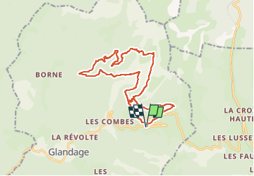
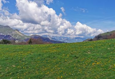
Tocht Te voet van 18,7 km beschikbaar op Auvergne-Rhône-Alpes, Drôme, Glandage. Deze tocht wordt voorgesteld door Christiancordin.
Beschrijving
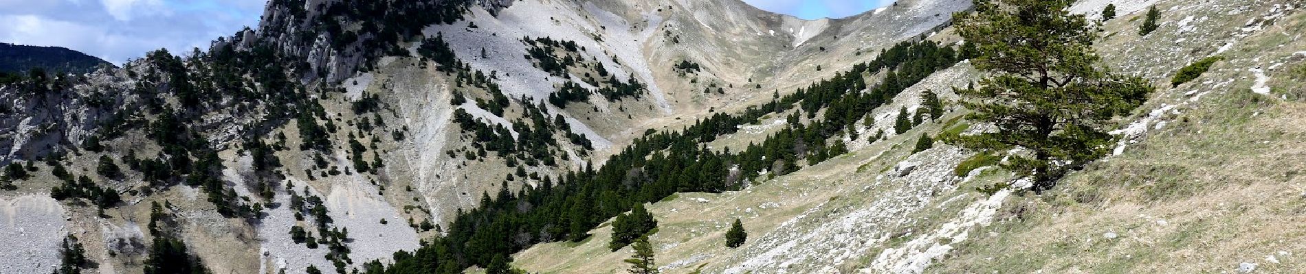
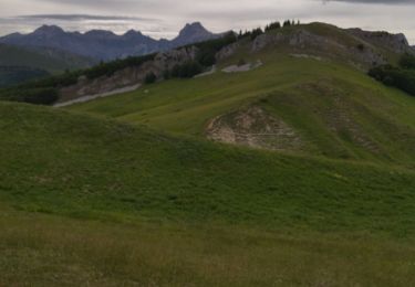
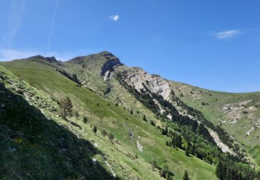
D Grimone (gîte), la Pouyat, GR 93, ravin de Clastre, col de la Peyère, Côte Pleine, les sucettes de Borne, col Lachau 1484m, la Grande Plâte, ravin de Clastre, Grimone.
Plaatsbepaling
Land:
France
Regio :
Auvergne-Rhône-Alpes
Departement/Provincie :
Drôme
Gemeente :
Glandage
Locatie:
Unknown
Vertrek:(Dec)
Vertrek:(UTM)
708799 ; 4952572 (31T) N.
Opmerkingen
Wandeltochten in de omgeving
![Tocht Stappen Glandage - Le Jocou 2 - Photo](https://media.geolcdn.com/t/375/260/3db953da-6976-42b8-b004-e2f45e4d2956.jpg&format=jpg&maxdim=2)
![Stappen Stappen](https://static1.geolcdn.com/sitytour/trail-icons/101.png)
Le Jocou 2
Stappen
Moeilijk
Glandage,
Auvergne-Rhône-Alpes,
Drôme,
France
![](/images/other/stat-length.png)
8,5 km | 18,1 km-effort
4h 0min
![](https://static1.geolcdn.com/siteimages/upload/files/16400158638029165_repeat_loop_refresh_sync_direction_icon.png)
Ja
![Tocht Stappen Glandage - 2022-09-05_12h23m25_Le Jocou-col de Seysse 12km.gpx (2).xml - Photo](https://media.geolcdn.com/t/375/260/7fa8e50f-0ae3-4fbb-b69e-805ffe4b1242.jpg&format=jpg&maxdim=2)
![Stappen Stappen](https://static1.geolcdn.com/sitytour/trail-icons/101.png)
2022-09-05_12h23m25_Le Jocou-col de Seysse 12km.gpx (2).xml
Stappen
Zeer moeilijk
Glandage,
Auvergne-Rhône-Alpes,
Drôme,
France
![](/images/other/stat-length.png)
11,6 km | 24 km-effort
5h 27min
![](https://static1.geolcdn.com/siteimages/upload/files/16400158638029165_repeat_loop_refresh_sync_direction_icon.png)
Ja
![Tocht Stappen Glandage - 2022-06-24_19h10m37_Le Jocou par crêtes des Amousières 10km.gpx.xml - Photo](https://media.geolcdn.com/t/375/260/eeeff28a-8806-426d-aef8-2ba384b53865.jpg&format=jpg&maxdim=2)
![Stappen Stappen](https://static1.geolcdn.com/sitytour/trail-icons/101.png)
2022-06-24_19h10m37_Le Jocou par crêtes des Amousières 10km.gpx.xml
Stappen
Zeer moeilijk
Glandage,
Auvergne-Rhône-Alpes,
Drôme,
France
![](/images/other/stat-length.png)
9,6 km | 22 km-effort
5h 9min
![](https://static1.geolcdn.com/siteimages/upload/files/16400158638029165_repeat_loop_refresh_sync_direction_icon.png)
Ja
![Tocht Stappen Glandage - Grimone-Le Jocou 12km - Photo](https://media.geolcdn.com/t/375/260/cd25f2bd-a51d-4184-be3b-7961b829b3e2.jpg&format=jpg&maxdim=2)
![Stappen Stappen](https://static1.geolcdn.com/sitytour/trail-icons/101.png)
Grimone-Le Jocou 12km
Stappen
Moeilijk
Glandage,
Auvergne-Rhône-Alpes,
Drôme,
France
![](/images/other/stat-length.png)
12 km | 24 km-effort
6h 0min
![](https://static1.geolcdn.com/siteimages/upload/files/16400158638029165_repeat_loop_refresh_sync_direction_icon.png)
Ja
![Te voet Te voet](https://static1.geolcdn.com/sitytour/trail-icons/100.png)
2024-04-17_Au fil du Buech
Te voet
Gemakkelijk
Lus-la-Croix-Haute,
Auvergne-Rhône-Alpes,
Drôme,
France
![](/images/other/stat-length.png)
7,5 km | 12,2 km-effort
2h 45min
![](https://static1.geolcdn.com/siteimages/upload/files/16400158638029165_repeat_loop_refresh_sync_direction_icon.png)
Ja
![Te voet Te voet](https://static1.geolcdn.com/sitytour/trail-icons/100.png)
2024-04-15_L'Aupillon
Te voet
Medium
Lus-la-Croix-Haute,
Auvergne-Rhône-Alpes,
Drôme,
France
![](/images/other/stat-length.png)
8,3 km | 14,5 km-effort
3h 17min
![](https://static1.geolcdn.com/siteimages/upload/files/16400158638029165_repeat_loop_refresh_sync_direction_icon.png)
Ja
![Tocht Stappen Glandage - col menée - Photo](https://media.geolcdn.com/t/375/260/e241c69a-c216-4a1a-8e3f-904d3c89ecaa.jpg&format=jpg&maxdim=2)
![Stappen Stappen](https://static1.geolcdn.com/sitytour/trail-icons/101.png)
col menée
Stappen
Medium
Glandage,
Auvergne-Rhône-Alpes,
Drôme,
France
![](/images/other/stat-length.png)
16,2 km | 28 km-effort
7h 10min
![](https://static1.geolcdn.com/siteimages/upload/files/16400158638029165_repeat_loop_refresh_sync_direction_icon.png)
Neen
![Tocht Stappen Lus-la-Croix-Haute - Antécime de La Toussière - Photo](https://media.geolcdn.com/t/375/260/87605781-6a50-4697-8890-c52173f8ef2c.jpg&format=jpg&maxdim=2)
![Stappen Stappen](https://static1.geolcdn.com/sitytour/trail-icons/101.png)
Antécime de La Toussière
Stappen
Moeilijk
Lus-la-Croix-Haute,
Auvergne-Rhône-Alpes,
Drôme,
France
![](/images/other/stat-length.png)
8,6 km | 17,4 km-effort
5h 44min
![](https://static1.geolcdn.com/siteimages/upload/files/16400158638029165_repeat_loop_refresh_sync_direction_icon.png)
Ja
![Tocht Stappen Lalley - Serre Motaire et Lazare - Photo](https://media.geolcdn.com/t/375/260/7569b2e0-3d3e-4ed6-980b-6f2683deb4dc.jpg&format=jpg&maxdim=2)
![Stappen Stappen](https://static1.geolcdn.com/sitytour/trail-icons/101.png)
Serre Motaire et Lazare
Stappen
Zeer moeilijk
Lalley,
Auvergne-Rhône-Alpes,
Isère,
France
![](/images/other/stat-length.png)
14,6 km | 24 km-effort
23h 45min
![](https://static1.geolcdn.com/siteimages/upload/files/16400158638029165_repeat_loop_refresh_sync_direction_icon.png)
Ja