


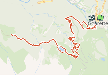

6,7 km | 12,3 km-effort

Gebruiker GUIDE


Gratisgps-wandelapplicatie
 SityTrail
IGN / Geografische instituten
SityTrail World
De wereld gaat voor u open
Tocht Lopen van 9,9 km beschikbaar op Nieuw-Aquitanië, Pyrénées-Atlantiques, Eaux-Bonnes. Deze tocht wordt voorgesteld door marmotte65.
Rando plus dure qu'il ni paraît (attention au nombreux VTT en saison estivale) la montée sur la piste en plein soleil est assez éprouvante.
Les sentiers a emprunter piste raquettes a neige ou VTT sont assez difficile a trouver .
rectifier cette trace a la descente derriere l'arrivée du télécabine (trop raide et dangereuse). ne pas emprunter les pistes VTT dans le sens descente le danger venant de derriere .
bref une rando facile a partir de l'arrivée du telecabine
 "
data-pinterest-text="Pin it"
data-tweet-text="share on twitter"
data-facebook-share-url="https://www.sitytrail.com/nl/trails/4135504-eauxxbonnes--gourette--la-cabane-de-bouy--x4135504x/?photo=1#lg=1&slide=1"
data-twitter-share-url="https://www.sitytrail.com/nl/trails/4135504-eauxxbonnes--gourette--la-cabane-de-bouy--x4135504x/?photo=1#lg=1&slide=1"
data-googleplus-share-url="https://www.sitytrail.com/nl/trails/4135504-eauxxbonnes--gourette--la-cabane-de-bouy--x4135504x/?photo=1#lg=1&slide=1"
data-pinterest-share-url="https://www.sitytrail.com/nl/trails/4135504-eauxxbonnes--gourette--la-cabane-de-bouy--x4135504x/?photo=1#lg=1&slide=1">
"
data-pinterest-text="Pin it"
data-tweet-text="share on twitter"
data-facebook-share-url="https://www.sitytrail.com/nl/trails/4135504-eauxxbonnes--gourette--la-cabane-de-bouy--x4135504x/?photo=1#lg=1&slide=1"
data-twitter-share-url="https://www.sitytrail.com/nl/trails/4135504-eauxxbonnes--gourette--la-cabane-de-bouy--x4135504x/?photo=1#lg=1&slide=1"
data-googleplus-share-url="https://www.sitytrail.com/nl/trails/4135504-eauxxbonnes--gourette--la-cabane-de-bouy--x4135504x/?photo=1#lg=1&slide=1"
data-pinterest-share-url="https://www.sitytrail.com/nl/trails/4135504-eauxxbonnes--gourette--la-cabane-de-bouy--x4135504x/?photo=1#lg=1&slide=1">
 "
data-pinterest-text="Pin it"
data-tweet-text="share on twitter"
data-facebook-share-url="https://www.sitytrail.com/nl/trails/4135504-eauxxbonnes--gourette--la-cabane-de-bouy--x4135504x/?photo=2#lg=1&slide=2"
data-twitter-share-url="https://www.sitytrail.com/nl/trails/4135504-eauxxbonnes--gourette--la-cabane-de-bouy--x4135504x/?photo=2#lg=1&slide=2"
data-googleplus-share-url="https://www.sitytrail.com/nl/trails/4135504-eauxxbonnes--gourette--la-cabane-de-bouy--x4135504x/?photo=2#lg=1&slide=2"
data-pinterest-share-url="https://www.sitytrail.com/nl/trails/4135504-eauxxbonnes--gourette--la-cabane-de-bouy--x4135504x/?photo=2#lg=1&slide=2">
"
data-pinterest-text="Pin it"
data-tweet-text="share on twitter"
data-facebook-share-url="https://www.sitytrail.com/nl/trails/4135504-eauxxbonnes--gourette--la-cabane-de-bouy--x4135504x/?photo=2#lg=1&slide=2"
data-twitter-share-url="https://www.sitytrail.com/nl/trails/4135504-eauxxbonnes--gourette--la-cabane-de-bouy--x4135504x/?photo=2#lg=1&slide=2"
data-googleplus-share-url="https://www.sitytrail.com/nl/trails/4135504-eauxxbonnes--gourette--la-cabane-de-bouy--x4135504x/?photo=2#lg=1&slide=2"
data-pinterest-share-url="https://www.sitytrail.com/nl/trails/4135504-eauxxbonnes--gourette--la-cabane-de-bouy--x4135504x/?photo=2#lg=1&slide=2">
 "
data-pinterest-text="Pin it"
data-tweet-text="share on twitter"
data-facebook-share-url="https://www.sitytrail.com/nl/trails/4135504-eauxxbonnes--gourette--la-cabane-de-bouy--x4135504x/?photo=3#lg=1&slide=3"
data-twitter-share-url="https://www.sitytrail.com/nl/trails/4135504-eauxxbonnes--gourette--la-cabane-de-bouy--x4135504x/?photo=3#lg=1&slide=3"
data-googleplus-share-url="https://www.sitytrail.com/nl/trails/4135504-eauxxbonnes--gourette--la-cabane-de-bouy--x4135504x/?photo=3#lg=1&slide=3"
data-pinterest-share-url="https://www.sitytrail.com/nl/trails/4135504-eauxxbonnes--gourette--la-cabane-de-bouy--x4135504x/?photo=3#lg=1&slide=3">
"
data-pinterest-text="Pin it"
data-tweet-text="share on twitter"
data-facebook-share-url="https://www.sitytrail.com/nl/trails/4135504-eauxxbonnes--gourette--la-cabane-de-bouy--x4135504x/?photo=3#lg=1&slide=3"
data-twitter-share-url="https://www.sitytrail.com/nl/trails/4135504-eauxxbonnes--gourette--la-cabane-de-bouy--x4135504x/?photo=3#lg=1&slide=3"
data-googleplus-share-url="https://www.sitytrail.com/nl/trails/4135504-eauxxbonnes--gourette--la-cabane-de-bouy--x4135504x/?photo=3#lg=1&slide=3"
data-pinterest-share-url="https://www.sitytrail.com/nl/trails/4135504-eauxxbonnes--gourette--la-cabane-de-bouy--x4135504x/?photo=3#lg=1&slide=3">
 "
data-pinterest-text="Pin it"
data-tweet-text="share on twitter"
data-facebook-share-url="https://www.sitytrail.com/nl/trails/4135504-eauxxbonnes--gourette--la-cabane-de-bouy--x4135504x/?photo=4#lg=1&slide=4"
data-twitter-share-url="https://www.sitytrail.com/nl/trails/4135504-eauxxbonnes--gourette--la-cabane-de-bouy--x4135504x/?photo=4#lg=1&slide=4"
data-googleplus-share-url="https://www.sitytrail.com/nl/trails/4135504-eauxxbonnes--gourette--la-cabane-de-bouy--x4135504x/?photo=4#lg=1&slide=4"
data-pinterest-share-url="https://www.sitytrail.com/nl/trails/4135504-eauxxbonnes--gourette--la-cabane-de-bouy--x4135504x/?photo=4#lg=1&slide=4">
"
data-pinterest-text="Pin it"
data-tweet-text="share on twitter"
data-facebook-share-url="https://www.sitytrail.com/nl/trails/4135504-eauxxbonnes--gourette--la-cabane-de-bouy--x4135504x/?photo=4#lg=1&slide=4"
data-twitter-share-url="https://www.sitytrail.com/nl/trails/4135504-eauxxbonnes--gourette--la-cabane-de-bouy--x4135504x/?photo=4#lg=1&slide=4"
data-googleplus-share-url="https://www.sitytrail.com/nl/trails/4135504-eauxxbonnes--gourette--la-cabane-de-bouy--x4135504x/?photo=4#lg=1&slide=4"
data-pinterest-share-url="https://www.sitytrail.com/nl/trails/4135504-eauxxbonnes--gourette--la-cabane-de-bouy--x4135504x/?photo=4#lg=1&slide=4">
 "
data-pinterest-text="Pin it"
data-tweet-text="share on twitter"
data-facebook-share-url="https://www.sitytrail.com/nl/trails/4135504-eauxxbonnes--gourette--la-cabane-de-bouy--x4135504x/?photo=5#lg=1&slide=5"
data-twitter-share-url="https://www.sitytrail.com/nl/trails/4135504-eauxxbonnes--gourette--la-cabane-de-bouy--x4135504x/?photo=5#lg=1&slide=5"
data-googleplus-share-url="https://www.sitytrail.com/nl/trails/4135504-eauxxbonnes--gourette--la-cabane-de-bouy--x4135504x/?photo=5#lg=1&slide=5"
data-pinterest-share-url="https://www.sitytrail.com/nl/trails/4135504-eauxxbonnes--gourette--la-cabane-de-bouy--x4135504x/?photo=5#lg=1&slide=5">
"
data-pinterest-text="Pin it"
data-tweet-text="share on twitter"
data-facebook-share-url="https://www.sitytrail.com/nl/trails/4135504-eauxxbonnes--gourette--la-cabane-de-bouy--x4135504x/?photo=5#lg=1&slide=5"
data-twitter-share-url="https://www.sitytrail.com/nl/trails/4135504-eauxxbonnes--gourette--la-cabane-de-bouy--x4135504x/?photo=5#lg=1&slide=5"
data-googleplus-share-url="https://www.sitytrail.com/nl/trails/4135504-eauxxbonnes--gourette--la-cabane-de-bouy--x4135504x/?photo=5#lg=1&slide=5"
data-pinterest-share-url="https://www.sitytrail.com/nl/trails/4135504-eauxxbonnes--gourette--la-cabane-de-bouy--x4135504x/?photo=5#lg=1&slide=5">
 "
data-pinterest-text="Pin it"
data-tweet-text="share on twitter"
data-facebook-share-url="https://www.sitytrail.com/nl/trails/4135504-eauxxbonnes--gourette--la-cabane-de-bouy--x4135504x/?photo=6#lg=1&slide=6"
data-twitter-share-url="https://www.sitytrail.com/nl/trails/4135504-eauxxbonnes--gourette--la-cabane-de-bouy--x4135504x/?photo=6#lg=1&slide=6"
data-googleplus-share-url="https://www.sitytrail.com/nl/trails/4135504-eauxxbonnes--gourette--la-cabane-de-bouy--x4135504x/?photo=6#lg=1&slide=6"
data-pinterest-share-url="https://www.sitytrail.com/nl/trails/4135504-eauxxbonnes--gourette--la-cabane-de-bouy--x4135504x/?photo=6#lg=1&slide=6">
"
data-pinterest-text="Pin it"
data-tweet-text="share on twitter"
data-facebook-share-url="https://www.sitytrail.com/nl/trails/4135504-eauxxbonnes--gourette--la-cabane-de-bouy--x4135504x/?photo=6#lg=1&slide=6"
data-twitter-share-url="https://www.sitytrail.com/nl/trails/4135504-eauxxbonnes--gourette--la-cabane-de-bouy--x4135504x/?photo=6#lg=1&slide=6"
data-googleplus-share-url="https://www.sitytrail.com/nl/trails/4135504-eauxxbonnes--gourette--la-cabane-de-bouy--x4135504x/?photo=6#lg=1&slide=6"
data-pinterest-share-url="https://www.sitytrail.com/nl/trails/4135504-eauxxbonnes--gourette--la-cabane-de-bouy--x4135504x/?photo=6#lg=1&slide=6">
 "
data-pinterest-text="Pin it"
data-tweet-text="share on twitter"
data-facebook-share-url="https://www.sitytrail.com/nl/trails/4135504-eauxxbonnes--gourette--la-cabane-de-bouy--x4135504x/?photo=7#lg=1&slide=7"
data-twitter-share-url="https://www.sitytrail.com/nl/trails/4135504-eauxxbonnes--gourette--la-cabane-de-bouy--x4135504x/?photo=7#lg=1&slide=7"
data-googleplus-share-url="https://www.sitytrail.com/nl/trails/4135504-eauxxbonnes--gourette--la-cabane-de-bouy--x4135504x/?photo=7#lg=1&slide=7"
data-pinterest-share-url="https://www.sitytrail.com/nl/trails/4135504-eauxxbonnes--gourette--la-cabane-de-bouy--x4135504x/?photo=7#lg=1&slide=7">
"
data-pinterest-text="Pin it"
data-tweet-text="share on twitter"
data-facebook-share-url="https://www.sitytrail.com/nl/trails/4135504-eauxxbonnes--gourette--la-cabane-de-bouy--x4135504x/?photo=7#lg=1&slide=7"
data-twitter-share-url="https://www.sitytrail.com/nl/trails/4135504-eauxxbonnes--gourette--la-cabane-de-bouy--x4135504x/?photo=7#lg=1&slide=7"
data-googleplus-share-url="https://www.sitytrail.com/nl/trails/4135504-eauxxbonnes--gourette--la-cabane-de-bouy--x4135504x/?photo=7#lg=1&slide=7"
data-pinterest-share-url="https://www.sitytrail.com/nl/trails/4135504-eauxxbonnes--gourette--la-cabane-de-bouy--x4135504x/?photo=7#lg=1&slide=7">
 "
data-pinterest-text="Pin it"
data-tweet-text="share on twitter"
data-facebook-share-url="https://www.sitytrail.com/nl/trails/4135504-eauxxbonnes--gourette--la-cabane-de-bouy--x4135504x/?photo=8#lg=1&slide=8"
data-twitter-share-url="https://www.sitytrail.com/nl/trails/4135504-eauxxbonnes--gourette--la-cabane-de-bouy--x4135504x/?photo=8#lg=1&slide=8"
data-googleplus-share-url="https://www.sitytrail.com/nl/trails/4135504-eauxxbonnes--gourette--la-cabane-de-bouy--x4135504x/?photo=8#lg=1&slide=8"
data-pinterest-share-url="https://www.sitytrail.com/nl/trails/4135504-eauxxbonnes--gourette--la-cabane-de-bouy--x4135504x/?photo=8#lg=1&slide=8">
"
data-pinterest-text="Pin it"
data-tweet-text="share on twitter"
data-facebook-share-url="https://www.sitytrail.com/nl/trails/4135504-eauxxbonnes--gourette--la-cabane-de-bouy--x4135504x/?photo=8#lg=1&slide=8"
data-twitter-share-url="https://www.sitytrail.com/nl/trails/4135504-eauxxbonnes--gourette--la-cabane-de-bouy--x4135504x/?photo=8#lg=1&slide=8"
data-googleplus-share-url="https://www.sitytrail.com/nl/trails/4135504-eauxxbonnes--gourette--la-cabane-de-bouy--x4135504x/?photo=8#lg=1&slide=8"
data-pinterest-share-url="https://www.sitytrail.com/nl/trails/4135504-eauxxbonnes--gourette--la-cabane-de-bouy--x4135504x/?photo=8#lg=1&slide=8">


Te voet

Stappen


sport

Te voet
Te voet

Te voet

Te voet

Stappen
Stappen