![](/images/other/stat-length.png)
![Tocht Stappen Seine-Port - Seine-Port - Forêt de Bréviande - Photo](https://media.geolcdn.com/t/1900/400/51a389bc-b3c8-4be1-ba86-e8ef4354e797.jpg&format=pjpeg&maxdim=2)
Seine-Port - Forêt de Bréviande
guydu41
Gebruiker
![Lengte](/images/other/stat-length.png)
![Max. hoogte](https://static1.geolcdn.com/siteimages/upload/files/1508320355ic_sort_altitude_max_24dp.png)
![Positief hoogteverschil](https://static1.geolcdn.com/siteimages/upload/files/1508320355ic_sort_den_pos_24dp.png)
![Km-Effort](/images/other/stat-length.png)
![Min. hoogte](https://static1.geolcdn.com/siteimages/upload/files/1508320355ic_sort_altitude_min_24dp.png)
![Negatief hoogteverschil](https://static1.geolcdn.com/siteimages/upload/files/1508320355ic_sort_den_neg_24dp.png)
![Boucle](https://static1.geolcdn.com/siteimages/upload/files/16400158638029165_repeat_loop_refresh_sync_direction_icon.png)
![Stappen](https://static1.geolcdn.com/sitytour/trail-icons/101.png)
1h59
Moeilijkheid : Moeilijk
![Scan deze QR-code om de tocht te openen in de SityTrail-applicatie](https://capi.geolives.com/qq0zvz2zws4bq2lad0pu/sitytour/trails/4103529/qr.png?size=200)
Gratisgps-wandelapplicatie
Over ons
Tocht Stappen van 7,7 km beschikbaar op Île-de-France, Seine-et-Marne, Seine-Port. Deze tocht wordt voorgesteld door guydu41.
Beschrijving
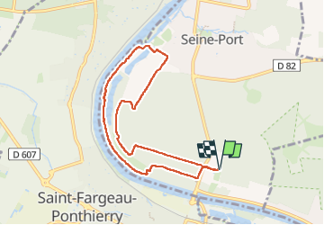
Ce circuit en sens antihoraire commence depuis le parking 1 Allée Watteau, 77240 Seine-Port à l'extrémité de l'Allé Madame Montesson depuis la D50.
Il n'emprunte que des chemins à travers la Forêt de Bréviande et un sentier étroit et tortueux en bord de Seine.
La première difficulté est d'enjamber plusieurs arbres tombés en travers du sentier.
La deuxième est le franchissement d'un petit chenal au point 4,65 km de la trace enregistrée qui peut être inondé (nécessité de marcher pieds nus sur des cailloux coupants ou de mettre temporairement de petites sandales en plastique).
La troisième complication est que du point 6,4 km jusqu'au Pont Maréchal Juin le sentier a été complètement défoncé par des exploitants forestiers. Cela le rend impraticable surtout quand la terre est boueuse.
Nécessité de remonter sur le haut du coteau par des chemins très dégradés pour rejoindre la piste cyclable et revenir au parking.
Note : Le parcours proposé n'est à faire que si vous avez une âme d'explorateur, de bonnes chaussures de randonnée et une marche bien assurée.
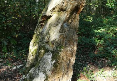
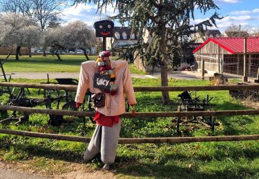
Plaatsbepaling
Opmerkingen
Wandeltochten in de omgeving
![Tocht Stappen Savigny-le-Temple - Entre Savigny-le-Temple et Seine-Port - Photo](https://media.geolcdn.com/t/375/260/bf4e2a57-0e1f-461a-a57c-e80897282f7a.jpg&format=jpg&maxdim=2)
![Stappen Stappen](https://static1.geolcdn.com/sitytour/trail-icons/101.png)
Stappen
![](/images/other/stat-length.png)
![](https://static1.geolcdn.com/siteimages/upload/files/16400158638029165_repeat_loop_refresh_sync_direction_icon.png)
![Tocht Stappen Nandy - La Forêt de Rougeau - Photo](https://media.geolcdn.com/t/375/260/080e44a1-3383-464c-9323-aaa25c1e4163.jpg&format=jpg&maxdim=2)
![Stappen Stappen](https://static1.geolcdn.com/sitytour/trail-icons/101.png)
Stappen
![](/images/other/stat-length.png)
![](https://static1.geolcdn.com/siteimages/upload/files/16400158638029165_repeat_loop_refresh_sync_direction_icon.png)
![Tocht Stappen Cesson - JC 20 19.50 km - Cesson la Forêt, forêt de Bréviande - Photo](https://media.geolcdn.com/t/375/260/a57f3f1c-b363-4986-b848-ebc6a7416d96.jpg&format=jpg&maxdim=2)
![Stappen Stappen](https://static1.geolcdn.com/sitytour/trail-icons/101.png)
Stappen
![](/images/other/stat-length.png)
![](https://static1.geolcdn.com/siteimages/upload/files/16400158638029165_repeat_loop_refresh_sync_direction_icon.png)
![Tocht Stappen Cesson - 2020-09-30_18h09m29_JaINFIZemJ8 - Photo](https://media.geolcdn.com/t/375/260/204fcfa0-de27-435f-8136-b0f0ee7ffa56.jpg&format=jpg&maxdim=2)
![Stappen Stappen](https://static1.geolcdn.com/sitytour/trail-icons/101.png)
Stappen
![](/images/other/stat-length.png)
![](https://static1.geolcdn.com/siteimages/upload/files/16400158638029165_repeat_loop_refresh_sync_direction_icon.png)
![Tocht Lopen Seine-Port - Fore?t de Rougeau et bords de Seine - Photo](https://media.geolcdn.com/t/375/260/ext.jpg?maxdim=2&url=https%3A%2F%2Fservices.sitytrail.com%2FGeolivesWS%2FDownloadMedia.ashx%3FTrailID%3D105548%26Media%3D9311_1.jpg)
![Lopen Lopen](https://static1.geolcdn.com/sitytour/trail-icons/103.png)
Lopen
![](/images/other/stat-length.png)
![](https://static1.geolcdn.com/siteimages/upload/files/16400158638029165_repeat_loop_refresh_sync_direction_icon.png)
![Tocht Stappen Saint-Fargeau-Ponthierry - Boucle 20 km Saint Fargeau - Photo](https://media.geolcdn.com/t/375/260/1121cafc-c79f-4e4a-a841-485665e96120.jpg&format=jpg&maxdim=2)
![Stappen Stappen](https://static1.geolcdn.com/sitytour/trail-icons/101.png)
Stappen
![](/images/other/stat-length.png)
![](https://static1.geolcdn.com/siteimages/upload/files/16400158638029165_repeat_loop_refresh_sync_direction_icon.png)
![Tocht Te voet Seine-Port - L 52 Les sentes de Seine Port - Photo](https://media.geolcdn.com/t/375/260/ext.jpg?maxdim=2&url=https%3A%2F%2Fstatic1.geolcdn.com%2Fsiteimages%2Fupload%2Ffiles%2F1545311037marcheuse_200dpi.jpg)
![Te voet Te voet](https://static1.geolcdn.com/sitytour/trail-icons/100.png)
Te voet
![](/images/other/stat-length.png)
![](https://static1.geolcdn.com/siteimages/upload/files/16400158638029165_repeat_loop_refresh_sync_direction_icon.png)
![Tocht Stappen Boissise-la-Bertrand - Boucle Boissise la BERTRAND 30 km - Photo](https://media.geolcdn.com/t/375/260/6730328b-3210-43a6-9f84-f1c044935aa5.jpg&format=jpg&maxdim=2)
![Stappen Stappen](https://static1.geolcdn.com/sitytour/trail-icons/101.png)
Stappen
![](/images/other/stat-length.png)
![](https://static1.geolcdn.com/siteimages/upload/files/16400158638029165_repeat_loop_refresh_sync_direction_icon.png)
![Tocht Stappen Vert-Saint-Denis - 20220330 - Forêt de Bréviande 15km - Photo](https://media.geolcdn.com/t/375/260/ext.jpg?maxdim=2&url=https%3A%2F%2Fstatic1.geolcdn.com%2Fsiteimages%2Fupload%2Ffiles%2F1553511878bg_sport_marche.png)
![Stappen Stappen](https://static1.geolcdn.com/sitytour/trail-icons/101.png)
Stappen
![](/images/other/stat-length.png)
![](https://static1.geolcdn.com/siteimages/upload/files/16400158638029165_repeat_loop_refresh_sync_direction_icon.png)