![](/images/other/stat-length.png)
![Tocht Stappen Mayres - 2024-06-22_13h40m20_mayres-gt-thueyts-reco-jef - Photo](https://media.geolcdn.com/t/1900/400/ext.pjpeg?maxdim=2&url=https%3A%2F%2Fstatic1.geolcdn.com%2Fsiteimages%2Fupload%2Ffiles%2F1553511878bg_sport_marche.png)
2024-06-22_13h40m20_mayres-gt-thueyts-reco-jef
Maryma
Gebruiker
![Lengte](/images/other/stat-length.png)
![Max. hoogte](https://static1.geolcdn.com/siteimages/upload/files/1508320355ic_sort_altitude_max_24dp.png)
![Positief hoogteverschil](https://static1.geolcdn.com/siteimages/upload/files/1508320355ic_sort_den_pos_24dp.png)
![Km-Effort](/images/other/stat-length.png)
![Min. hoogte](https://static1.geolcdn.com/siteimages/upload/files/1508320355ic_sort_altitude_min_24dp.png)
![Negatief hoogteverschil](https://static1.geolcdn.com/siteimages/upload/files/1508320355ic_sort_den_neg_24dp.png)
![Boucle](https://static1.geolcdn.com/siteimages/upload/files/16400158638029165_repeat_loop_refresh_sync_direction_icon.png)
![Stappen](https://static1.geolcdn.com/sitytour/trail-icons/101.png)
5h00
Moeilijkheid : Moeilijk
![Scan deze QR-code om de tocht te openen in de SityTrail-applicatie](https://capi.geolives.com/qq0zvz2zws4bq2lad0pu/sitytour/trails/4099022/qr.png?size=200)
Gratisgps-wandelapplicatie
Over ons
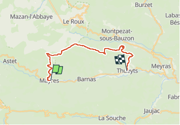
Tocht Stappen van 21 km beschikbaar op Auvergne-Rhône-Alpes, Ardèche, Mayres. Deze tocht wordt voorgesteld door Maryma.
Beschrijving
La rando n'est pas en boucle.
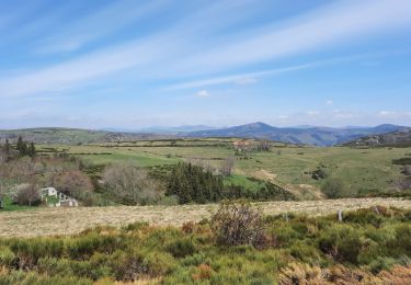
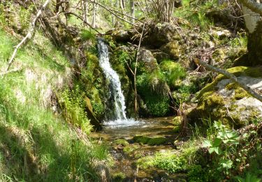
L'essentiel de la montée se fait sur les 4 premiers kilomètres ; passages en sous bois et quelques pas sur rochers sans difficulté. De très beaux panoramas. De Mayres jusqu'au Mont Gerbier et Mont Mézenc. En ce mois de juin, les genets en fleurs nous en mettent plein les yeux.
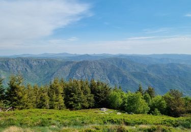
Passage par le cratère de la Crose, volcan strombolien. Classé en tant que Géoparc mondial. Nous descendons dans la cuvette qu'il a laissé. Rien de spectaculaire. Après la remontée, sur le chemin du parking au-dessus de Thueyts, nous marchons sur les restes de scories du volcan ; des projections de roches, appelées Pouzzolanes (riches en gaz).
Plaatsbepaling
Opmerkingen
Wandeltochten in de omgeving
![Tocht Stappen Mayres - 07 rocher d abraham - Photo](https://media.geolcdn.com/t/375/260/ext.jpg?maxdim=2&url=https%3A%2F%2Fstatic1.geolcdn.com%2Fsiteimages%2Fupload%2Ffiles%2F1553511878bg_sport_marche.png)
![Stappen Stappen](https://static1.geolcdn.com/sitytour/trail-icons/101.png)
Stappen
![](/images/other/stat-length.png)
![](https://static1.geolcdn.com/siteimages/upload/files/16400158638029165_repeat_loop_refresh_sync_direction_icon.png)
![Tocht Stappen Borne - croix de beauzon - Photo](https://media.geolcdn.com/t/375/260/217677dd-c155-48af-bc87-419b5b32c8ce.jpg&format=jpg&maxdim=2)
![Stappen Stappen](https://static1.geolcdn.com/sitytour/trail-icons/101.png)
Stappen
![](/images/other/stat-length.png)
![](https://static1.geolcdn.com/siteimages/upload/files/16400158638029165_repeat_loop_refresh_sync_direction_icon.png)
![Tocht Stappen Mayres - Mayres Chaumiène 12km - Photo](https://media.geolcdn.com/t/375/260/a133b020-a8a4-4863-bdb6-488ddda17997.jpg&format=jpg&maxdim=2)
![Stappen Stappen](https://static1.geolcdn.com/sitytour/trail-icons/101.png)
Stappen
![](/images/other/stat-length.png)
![](https://static1.geolcdn.com/siteimages/upload/files/16400158638029165_repeat_loop_refresh_sync_direction_icon.png)
![Tocht Stappen Borne - 2023-01-26_14h31m24_Station Croix de Bauzon 14 km.gpx.xml - Photo](https://media.geolcdn.com/t/375/260/186f655e-2b32-453c-b04b-facbcec1469b.jpg&format=jpg&maxdim=2)
![Stappen Stappen](https://static1.geolcdn.com/sitytour/trail-icons/101.png)
Stappen
![](/images/other/stat-length.png)
![](https://static1.geolcdn.com/siteimages/upload/files/16400158638029165_repeat_loop_refresh_sync_direction_icon.png)
![Tocht Te voet Mayres - Tour des Poignets 18km - Photo](https://media.geolcdn.com/t/375/260/4695ff56-51f7-439d-a787-0d719ef81c46.jpg&format=jpg&maxdim=2)
![Te voet Te voet](https://static1.geolcdn.com/sitytour/trail-icons/100.png)
Te voet
![](/images/other/stat-length.png)
![](https://static1.geolcdn.com/siteimages/upload/files/16400158638029165_repeat_loop_refresh_sync_direction_icon.png)
![Tocht Stappen Borne - Vallée de la Borne - Photo](https://media.geolcdn.com/t/375/260/a1b498ea-d1c1-4335-9a23-7d6d1fab4a20.jpg&format=jpg&maxdim=2)
![Stappen Stappen](https://static1.geolcdn.com/sitytour/trail-icons/101.png)
Stappen
![](/images/other/stat-length.png)
![](https://static1.geolcdn.com/siteimages/upload/files/16400158638029165_repeat_loop_refresh_sync_direction_icon.png)
![Tocht Stappen La Souche - Rocher d'Abraham par la Tour des Poignets - Photo](https://media.geolcdn.com/t/375/260/7fafd23c-0b70-4e8a-8e13-fea6920ba10a.jpg&format=jpg&maxdim=2)
![Stappen Stappen](https://static1.geolcdn.com/sitytour/trail-icons/101.png)
Stappen
![](/images/other/stat-length.png)
![](https://static1.geolcdn.com/siteimages/upload/files/16400158638029165_repeat_loop_refresh_sync_direction_icon.png)
![Tocht Stappen Mayres - Mayres Chaumiène 12km - Photo](https://media.geolcdn.com/t/375/260/3d9e159f-ae3c-4dd5-9273-9d6647836aaa.jpg&format=jpg&maxdim=2)
![Stappen Stappen](https://static1.geolcdn.com/sitytour/trail-icons/101.png)
Stappen
![](/images/other/stat-length.png)
![](https://static1.geolcdn.com/siteimages/upload/files/16400158638029165_repeat_loop_refresh_sync_direction_icon.png)
![Tocht Stappen Mayres - SityTrail - 2747387 - mayes-cautet-piste-cesse-passadou - Photo](https://media.geolcdn.com/t/375/260/ext.jpg?maxdim=2&url=https%3A%2F%2Fstatic1.geolcdn.com%2Fsiteimages%2Fupload%2Ffiles%2F1553511878bg_sport_marche.png)
![Stappen Stappen](https://static1.geolcdn.com/sitytour/trail-icons/101.png)
Stappen
![](/images/other/stat-length.png)
![](https://static1.geolcdn.com/siteimages/upload/files/16400158638029165_repeat_loop_refresh_sync_direction_icon.png)