![](/images/other/stat-length.png)
![Tocht Stappen Chambord - Parc de Chambord et ses postes d'observation - Photo](https://media.geolcdn.com/t/1900/400/ext.pjpeg?maxdim=2&url=https%3A%2F%2Fmedia.geolcdn.com%2Ff%2F51ef8200-842e-48b6-be3e-cc6e5dd1e380.jpg)
Parc de Chambord et ses postes d'observation
guydu41
Gebruiker
![Lengte](/images/other/stat-length.png)
![Max. hoogte](https://static1.geolcdn.com/siteimages/upload/files/1508320355ic_sort_altitude_max_24dp.png)
![Positief hoogteverschil](https://static1.geolcdn.com/siteimages/upload/files/1508320355ic_sort_den_pos_24dp.png)
![Km-Effort](/images/other/stat-length.png)
![Min. hoogte](https://static1.geolcdn.com/siteimages/upload/files/1508320355ic_sort_altitude_min_24dp.png)
![Negatief hoogteverschil](https://static1.geolcdn.com/siteimages/upload/files/1508320355ic_sort_den_neg_24dp.png)
![Boucle](https://static1.geolcdn.com/siteimages/upload/files/16400158638029165_repeat_loop_refresh_sync_direction_icon.png)
![Stappen](https://static1.geolcdn.com/sitytour/trail-icons/101.png)
5h03
Moeilijkheid : Gemakkelijk
![Scan deze QR-code om de tocht te openen in de SityTrail-applicatie](https://capi.geolives.com/qq0zvz2zws4bq2lad0pu/sitytour/trails/4083694/qr.png?size=200)
Gratisgps-wandelapplicatie
Over ons
Tocht Stappen van 20 km beschikbaar op Centre-Val de Loire, Loir-et-Cher, Chambord. Deze tocht wordt voorgesteld door guydu41.
Beschrijving
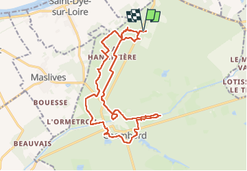
Ce circuit au départ du parking de la Gabillière sur la route François 1er (D112) dans le parc de Chambord permet d'accéder à une dizaine de postes d'observation de la faune sauvage.
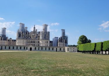
Il fait le tour du magnifique Château de Chambord, de longer les douves et une partie du Cosson.
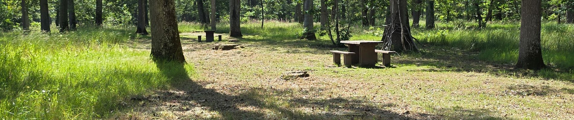
Il emprunte des allées, de très beaux chemins boisés et aussi de magnifiques sentiers tortueux dans la forêt.
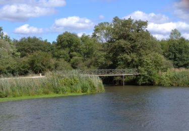
Le contournement de l'étang au Nord-Ouest de la Hannetière ne peut se faire que si son niveau d'eau est bas.
Plaatsbepaling
Opmerkingen
Wandeltochten in de omgeving
![Tocht Wegfiets Muides-sur-Loire - Itinéraire 12 - Au fil de Loire - Photo](https://media.geolcdn.com/t/375/260/ext.jpg?maxdim=2&url=https%3A%2F%2Fmedia.geolcdn.com%2Ff%2F47bcbb35-7685-4901-9cc8-e2f5b7c81fbb.jpg)
![Wegfiets Wegfiets](https://static1.geolcdn.com/sitytour/trail-icons/201.png)
Wegfiets
![](/images/other/stat-length.png)
![](https://static1.geolcdn.com/siteimages/upload/files/16400158638029165_repeat_loop_refresh_sync_direction_icon.png)
![Tocht Stappen Chambord - chambord chateau - Photo](https://media.geolcdn.com/t/375/260/ext.jpg?maxdim=2&url=https%3A%2F%2Fmedia.geolcdn.com%2Ff%2Fcf6dffb2-5150-4608-920d-a5eb0f29efb7.jpg)
![Stappen Stappen](https://static1.geolcdn.com/sitytour/trail-icons/101.png)
Stappen
![](/images/other/stat-length.png)
![](https://static1.geolcdn.com/siteimages/upload/files/16400158638029165_repeat_loop_refresh_sync_direction_icon.png)
![Tocht Te voet Chambord - petite marche 6 km dans chambord - Photo](https://media.geolcdn.com/t/375/260/ext.jpg?maxdim=2&url=https%3A%2F%2Fstatic1.geolcdn.com%2Fsiteimages%2Fupload%2Ffiles%2F1545311037marcheuse_200dpi.jpg)
![Te voet Te voet](https://static1.geolcdn.com/sitytour/trail-icons/100.png)
Te voet
![](/images/other/stat-length.png)
![](https://static1.geolcdn.com/siteimages/upload/files/16400158638029165_repeat_loop_refresh_sync_direction_icon.png)
![Tocht Hybride fiets Muides-sur-Loire - Muides Blois Chambord - Photo](https://media.geolcdn.com/t/375/260/ext.jpg?maxdim=2&url=https%3A%2F%2Fmedia.geolcdn.com%2Ff%2F5b17aaba-7088-482a-8248-c8104d907ec9.jpg)
![Hybride fiets Hybride fiets](https://static1.geolcdn.com/sitytour/trail-icons/203.png)
Hybride fiets
![](/images/other/stat-length.png)
![](https://static1.geolcdn.com/siteimages/upload/files/16400158638029165_repeat_loop_refresh_sync_direction_icon.png)
![Tocht Fietstoerisme Saint-Laurent-Nouan - Bois Renard - Blois et retour. - Photo](https://media.geolcdn.com/t/375/260/ext.jpg?maxdim=2&url=https%3A%2F%2Fmedia.geolcdn.com%2Ff%2Fb2b294ee-5ca4-4944-8204-8782a2675663.jpg)
![Fietstoerisme Fietstoerisme](https://static1.geolcdn.com/sitytour/trail-icons/204.png)
Fietstoerisme
![](/images/other/stat-length.png)
![](https://static1.geolcdn.com/siteimages/upload/files/16400158638029165_repeat_loop_refresh_sync_direction_icon.png)
![Tocht Mountainbike Chambord - chambord-cheverny - Photo](https://media.geolcdn.com/t/375/260/ext.jpg?maxdim=2&url=https%3A%2F%2Fstatic1.geolcdn.com%2Fsiteimages%2Fupload%2Ffiles%2F1524743154velo.jpg)
![Mountainbike Mountainbike](https://static1.geolcdn.com/sitytour/trail-icons/202.png)
Mountainbike
![](/images/other/stat-length.png)
![](https://static1.geolcdn.com/siteimages/upload/files/16400158638029165_repeat_loop_refresh_sync_direction_icon.png)
![Tocht Stappen Saint-Dyé-sur-Loire - saint dyé - Photo](https://media.geolcdn.com/t/375/260/ext.jpg?maxdim=2&url=https%3A%2F%2Fmedia.geolcdn.com%2Ff%2Fb561081d-29c1-4931-a6da-bd6848666230.jpg)
![Stappen Stappen](https://static1.geolcdn.com/sitytour/trail-icons/101.png)
Stappen
![](/images/other/stat-length.png)
![](https://static1.geolcdn.com/siteimages/upload/files/16400158638029165_repeat_loop_refresh_sync_direction_icon.png)
![Tocht Stappen Chambord - chambord - Photo](https://media.geolcdn.com/t/375/260/ext.jpg?maxdim=2&url=https%3A%2F%2Fmedia.geolcdn.com%2Ff%2F2bc465b8-76c7-44c7-8928-cd48b8d31b96.jpg)
![Stappen Stappen](https://static1.geolcdn.com/sitytour/trail-icons/101.png)
Stappen
![](/images/other/stat-length.png)
![](https://static1.geolcdn.com/siteimages/upload/files/16400158638029165_repeat_loop_refresh_sync_direction_icon.png)
![Tocht Stappen Chambord - Chambord-Rond point François 1° - Photo](https://media.geolcdn.com/t/375/260/ext.jpg?maxdim=2&url=https%3A%2F%2Fmedia.geolcdn.com%2Ff%2Fa858c52a-e2a1-404f-935d-6bce61c8915c.jpg)
![Stappen Stappen](https://static1.geolcdn.com/sitytour/trail-icons/101.png)
Stappen
![](/images/other/stat-length.png)
![](https://static1.geolcdn.com/siteimages/upload/files/16400158638029165_repeat_loop_refresh_sync_direction_icon.png)