![](/images/other/stat-length.png)
![Tocht Fiets Hamois - HAMOIS- Boucle de châteaux en châteaux - Photo](https://media.geolcdn.com/t/1900/400/ext.pjpeg?maxdim=2&url=https%3A%2F%2Fservices.sitytrail.com%2FGeolivesWS%2FDownloadMedia.ashx%3FTrailID%3D408311%26Media%3Dd8a71025-fe4d-4e69-b570-ad9926117b9a.jpg)
HAMOIS- Boucle de châteaux en châteaux
Vallées des Saveurs - Maison du Tourisme Condroz-Famenne
Destination Condroz-Famenne- une nature préservée PRO
![Lengte](/images/other/stat-length.png)
Lengte
17,7 km
![Max. hoogte](https://static1.geolcdn.com/siteimages/upload/files/1508320355ic_sort_altitude_max_24dp.png)
Max. hoogte
299 m
![Positief hoogteverschil](https://static1.geolcdn.com/siteimages/upload/files/1508320355ic_sort_den_pos_24dp.png)
Positief hoogteverschil
259 m
![Km-Effort](/images/other/stat-length.png)
Km-Effort
21 km
![Min. hoogte](https://static1.geolcdn.com/siteimages/upload/files/1508320355ic_sort_altitude_min_24dp.png)
Min. hoogte
224 m
![Negatief hoogteverschil](https://static1.geolcdn.com/siteimages/upload/files/1508320355ic_sort_den_neg_24dp.png)
Negatief hoogteverschil
260 m
![Boucle](https://static1.geolcdn.com/siteimages/upload/files/16400158638029165_repeat_loop_refresh_sync_direction_icon.png)
Boucle
Ja
Datum van aanmaak :
2015-09-11 00:00:00.0
Laatste wijziging :
2015-09-11 00:00:00.0
![Fiets](https://static1.geolcdn.com/sitytour/trail-icons/200.png)
5m
Moeilijkheid : Onbekend
![Scan deze QR-code om de tocht te openen in de SityTrail-applicatie](https://capi.geolives.com/qq0zvz2zws4bq2lad0pu/sitytour/trails/408311/qr.png?size=200)
Gratisgps-wandelapplicatie
Over ons
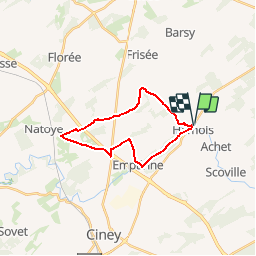
Tocht Fiets van 17,7 km beschikbaar op Wallonië, Namen, Hamois. Deze tocht wordt voorgesteld door Vallées des Saveurs - Maison du Tourisme Condroz-Famenne.
Beschrijving
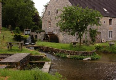
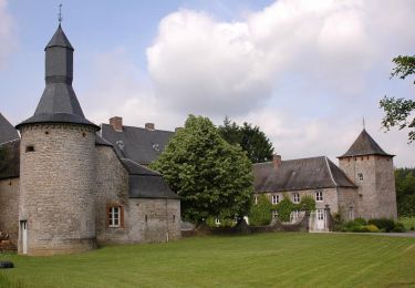
Circuit des Châteaux
POI's
Plaatsbepaling
Land:
Belgium
Regio :
Wallonië
Departement/Provincie :
Namen
Gemeente :
Hamois
Locatie:
Hamois
Vertrek:(Dec)
Vertrek:(UTM)
653660 ; 5578965 (31U) N.
Opmerkingen
Wandeltochten in de omgeving
![Tocht Stappen Hamois - HAMOIS- Scy (Mohiville)- Promenade du Berceau du Bocq - Photo](https://media.geolcdn.com/t/375/260/ext.jpg?maxdim=2&url=https%3A%2F%2Fservices.sitytrail.com%2FGeolivesWS%2FDownloadMedia.ashx%3FTrailID%3D250701%26Media%3D514f4968-57f7-4b3e-aef8-c121b3f2a3eb.jpg)
![Stappen Stappen](https://static1.geolcdn.com/sitytour/trail-icons/101.png)
HAMOIS- Scy (Mohiville)- Promenade du Berceau du Bocq
Stappen
Gemakkelijk
(12)
Hamois,
Wallonië,
Namen,
Belgium
![](/images/other/stat-length.png)
7,9 km | 9,8 km-effort
2h 4min
![](https://static1.geolcdn.com/siteimages/upload/files/16400158638029165_repeat_loop_refresh_sync_direction_icon.png)
Ja
![Tocht Stappen Hamois - HAMOIS- Schaltin- Promenade du Bois du Bocq au Colombier - Photo](https://media.geolcdn.com/t/375/260/ext.jpg?maxdim=2&url=https%3A%2F%2Fservices.sitytrail.com%2FGeolivesWS%2FDownloadMedia.ashx%3FTrailID%3D250699%26Media%3Df5fa6a8e-df6b-4e51-95e3-c58e93d30411.jpg)
![Stappen Stappen](https://static1.geolcdn.com/sitytour/trail-icons/101.png)
HAMOIS- Schaltin- Promenade du Bois du Bocq au Colombier
Stappen
Heel gemakkelijk
(7)
Hamois,
Wallonië,
Namen,
Belgium
![](/images/other/stat-length.png)
4,9 km | 5,8 km-effort
1h 15min
![](https://static1.geolcdn.com/siteimages/upload/files/16400158638029165_repeat_loop_refresh_sync_direction_icon.png)
Ja
![Tocht Te voet Hamois - Sentiers d'Art : Boucle 4 Hamois - Schaltin - Photo](https://media.geolcdn.com/t/375/260/2c7c2e61-e4de-40f0-ab0a-7cb107473369.jpg&format=jpg&maxdim=2)
![Te voet Te voet](https://static1.geolcdn.com/sitytour/trail-icons/100.png)
Sentiers d'Art : Boucle 4 Hamois - Schaltin
Te voet
Gemakkelijk
(1)
Hamois,
Wallonië,
Namen,
Belgium
![](/images/other/stat-length.png)
13,2 km | 16,3 km-effort
3h 42min
![](https://static1.geolcdn.com/siteimages/upload/files/16400158638029165_repeat_loop_refresh_sync_direction_icon.png)
Ja
![Tocht Stappen Hamois - HAMOIS- Hamois- Promenade du Tige al Creûjette - Photo](https://media.geolcdn.com/t/375/260/ext.jpg?maxdim=2&url=https%3A%2F%2Fservices.sitytrail.com%2FGeolivesWS%2FDownloadMedia.ashx%3FTrailID%3D250668%26Media%3D2dcd42b4-7825-4c6c-b964-62af389c92a8.jpg)
![Stappen Stappen](https://static1.geolcdn.com/sitytour/trail-icons/101.png)
HAMOIS- Hamois- Promenade du Tige al Creûjette
Stappen
Heel gemakkelijk
(3)
Hamois,
Wallonië,
Namen,
Belgium
![](/images/other/stat-length.png)
5,2 km | 6,3 km-effort
1h 22min
![](https://static1.geolcdn.com/siteimages/upload/files/16400158638029165_repeat_loop_refresh_sync_direction_icon.png)
Ja
![Tocht Stappen Hamois - HAMOIS- Achet- Promenade du Chapitre Saint-Paul en Tourlouette - Photo](https://media.geolcdn.com/t/375/260/ext.jpg?maxdim=2&url=https%3A%2F%2Fservices.sitytrail.com%2FGeolivesWS%2FDownloadMedia.ashx%3FTrailID%3D250667%26Media%3D711a5ab0-f1b5-4358-8e7d-16aef65342fb.jpg)
![Stappen Stappen](https://static1.geolcdn.com/sitytour/trail-icons/101.png)
HAMOIS- Achet- Promenade du Chapitre Saint-Paul en Tourlouette
Stappen
Gemakkelijk
(2)
Hamois,
Wallonië,
Namen,
Belgium
![](/images/other/stat-length.png)
7,3 km | 9 km-effort
1h 52min
![](https://static1.geolcdn.com/siteimages/upload/files/16400158638029165_repeat_loop_refresh_sync_direction_icon.png)
Ja
![Tocht Stappen Hamois - SENTIERS D'ART - 150 km - Assesse, Ciney, Gesves, Hamois, Havelange, Ohey et Somme-Leuze - Photo](https://media.geolcdn.com/t/375/260/ed3535b1-7f98-4002-879c-f79483ce43a3.jpg&format=jpg&maxdim=2)
![Stappen Stappen](https://static1.geolcdn.com/sitytour/trail-icons/101.png)
SENTIERS D'ART - 150 km - Assesse, Ciney, Gesves, Hamois, Havelange, Ohey et ...
Stappen
Zeer moeilijk
Hamois,
Wallonië,
Namen,
Belgium
![](/images/other/stat-length.png)
74 km | 91 km-effort
20h 36min
![](https://static1.geolcdn.com/siteimages/upload/files/16400158638029165_repeat_loop_refresh_sync_direction_icon.png)
Ja
![Tocht Stappen Hamois - La Promenade du Berceau du Bocq - Photo](https://media.geolcdn.com/t/375/260/c1ecebef-4dce-4991-920f-3cf80ab64a6d.jpg&format=jpg&maxdim=2)
![Stappen Stappen](https://static1.geolcdn.com/sitytour/trail-icons/101.png)
La Promenade du Berceau du Bocq
Stappen
Medium
(1)
Hamois,
Wallonië,
Namen,
Belgium
![](/images/other/stat-length.png)
9,3 km | 11,2 km-effort
4h 41min
![](https://static1.geolcdn.com/siteimages/upload/files/16400158638029165_repeat_loop_refresh_sync_direction_icon.png)
Ja
![Tocht Te voet Hamois - Du Val du Mauge au Tige de Buresse - Photo](https://media.geolcdn.com/t/375/260/ext.jpg?maxdim=2&url=https%3A%2F%2Fpivotmedia.tourismewallonie.be%2FOTH-A0-004I-17XW%2FOTH-A0-004I-17XW.jpg)
![Te voet Te voet](https://static1.geolcdn.com/sitytour/trail-icons/100.png)
Du Val du Mauge au Tige de Buresse
Te voet
Gemakkelijk
(1)
Hamois,
Wallonië,
Namen,
Belgium
![](/images/other/stat-length.png)
8,6 km | 10,6 km-effort
2h 23min
![](https://static1.geolcdn.com/siteimages/upload/files/16400158638029165_repeat_loop_refresh_sync_direction_icon.png)
Ja
![Tocht Te voet Hamois - Promenade du Berceau du Bocq - Photo](https://media.geolcdn.com/t/375/260/ext.jpg?maxdim=2&url=https%3A%2F%2Fpivotmedia.tourismewallonie.be%2FOTH-A0-001E-0END%2FOTH-A0-001E-0END.jpg)
![Te voet Te voet](https://static1.geolcdn.com/sitytour/trail-icons/100.png)
Promenade du Berceau du Bocq
Te voet
Gemakkelijk
Hamois,
Wallonië,
Namen,
Belgium
![](/images/other/stat-length.png)
7,9 km | 9,8 km-effort
2h 13min
![](https://static1.geolcdn.com/siteimages/upload/files/16400158638029165_repeat_loop_refresh_sync_direction_icon.png)
Ja