Tocht Stappen Fontaine-les-Coteaux - Fontaine-les-coteaux - Bois de Beauvoir - Photo

Fontaine-les-coteaux - Bois de Beauvoir

 guydu41
guydu41

Gebruiker

© OpenStreetMap contributors
Lengte
Lengte
11,7 km
Max. hoogte
Max. hoogte
141 m
Positief hoogteverschil
236 m
Km-Effort
Km-Effort  
14,8 km
Min. hoogte
Min. hoogte
70 m
Negatief hoogteverschil
236 m
Boucle
Boucle
Ja
Datum van aanmaak :
2024-06-06 12:07:14.563
Laatste wijziging :
2024-06-10 06:43:01.07

(0 Bericht)

Stappen
Stappen
3h22
Moeilijkheid : Medium

Scan deze QR-code om de tocht te openen in de SityTrail-applicatie

Gratisgps-wandelapplicatie

Logo SityTrail SityTrail

IGN / Geografische instituten

SityTrail uit de App Store downloaden SityTrail uit Google Play downloaden

Logo SityTrail SityTrail World

De wereld gaat voor u open

SityTrail uit de App Store downloaden SityTrail uit Google Play downloaden SityTrail op Huawei AppGallery downloaden

Over ons

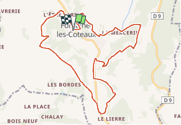
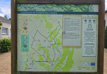
Tocht Stappen van 11,7 km beschikbaar op Centre-Val de Loire, Loir-et-Cher, Fontaine-les-Coteaux. Deze tocht wordt voorgesteld door guydu41.

Beschrijving

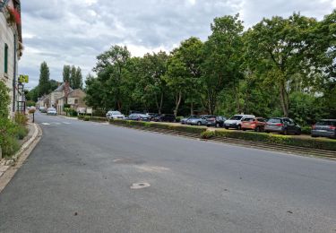
Le parcours démarre du parking à côté de la Mairie de Fontaine-les-Coteaux et de l'église Saint-Léonard. Un joli lavoir se trouve juste à côté.
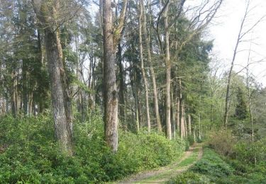
Ce circuit emprunte de nombreux chemins à travers champs et bois, monte sur les hauteurs bordant "le Grand Ri" par des sentiers, passe à côté de plusieurs cavités troglodytiques...
Note : Le sentier communal qui grimpe au-dessus du lieu-dit "la Camté" est très embroussaillé mais empruntable.

Hoogteprofiel

Foto's

43 fotos in totaal. Klik op een foto om ze allemaal in de galerij weer te geven.

Plaatsbepaling

Land:
France
Regio :
Centre-Val de Loire
Departement/Provincie :
Loir-et-Cher
Gemeente :
Fontaine-les-Coteaux
Locatie:
Unknown
Vertrek:(UTM)
337324 ; 5296209 (31T) N.

Wandeltochten in de omgeving

Tocht Stappen Fontaine-les-Coteaux - Fontaine-les-Coteaux - Bois de Beauvoir - Photo
Stappen
guydu41

Stappen

Gemakkelijk
Fontaine-les-Coteaux, Centre-Val de Loire, Loir-et-Cher, France
9,1 km | 11,4 km-effort
2h 14min
Ja
Tocht Stappen Les Roches-l'Évêque - Les Roches-l'Evêque - Photo
Stappen
guydu41

Stappen

Medium
Les Roches-l'Évêque, Centre-Val de Loire, Loir-et-Cher, France
8,8 km | 11,1 km-effort
2h 31min
Ja
Tocht Mountainbike Fontaine-les-Coteaux - VTT autour de Fontaine-les-Coteaux - Photo
Mountainbike
tracegps

Mountainbike

Moeilijk
Fontaine-les-Coteaux, Centre-Val de Loire, Loir-et-Cher, France
50 km | 59 km-effort
3h 0min
Ja
Tocht Stappen Trôo - Trôo - Saugé - GR AR - 20.5km 340m 4h30 - 2018 05 20 - Photo
Stappen
GUIDE
Orcal37

Stappen

Medium
Trôo, Centre-Val de Loire, Loir-et-Cher, France
20 km | 25 km-effort
4h 30min
Ja
Tocht Stappen Trôo - Trôo - 12.4km 280m 3h20 - 2017 05 28 - Photo
Stappen
GUIDE
Orcal37

Stappen

Medium
Trôo, Centre-Val de Loire, Loir-et-Cher, France
12,4 km | 15,8 km-effort
3h 20min
Ja
Tocht Stappen Trôo - Sentier des troglodytes à Trôo - Photo
Stappen
guydu41

Stappen

Moeilijk
Trôo, Centre-Val de Loire, Loir-et-Cher, France
2,6 km | 3,6 km-effort
1h 5min
Ja
Tocht Te voet Trôo - troo - Photo
Te voet
albg

Te voet

Heel gemakkelijk
Trôo, Centre-Val de Loire, Loir-et-Cher, France
16 km | 19 km-effort
Onbekend
Ja
Tocht Stappen Fontaine-les-Coteaux - Fontaine-les-coteaux - Photo
Stappen
guydu41

Stappen

Heel gemakkelijk
Fontaine-les-Coteaux, Centre-Val de Loire, Loir-et-Cher, France
18,2 km | 22 km-effort
4h 5min
Ja
Tocht Stappen Montoire-sur-le-Loir - Montoire 1.10.2023 - Photo
Stappen
jackalv

Stappen

Medium
Montoire-sur-le-Loir, Centre-Val de Loire, Loir-et-Cher, France
34 km | 40 km-effort
5h 28min
Ja


Sluiten
Mijn abonnementen