23 km | 29 km-effort
2024-06-09 Rando Souzy-la-Briche
jchezlemas
Gebruiker
Lengte
13,4 km
Max. hoogte
158 m
Positief hoogteverschil
199 m
Km-Effort
16,1 km
Min. hoogte
64 m
Negatief hoogteverschil
199 m
Boucle
Ja
Datum van aanmaak :
2024-06-05 06:58:49.417
Laatste wijziging :
2024-06-05 16:39:53.104
3h10
Moeilijkheid : Gemakkelijk
Gratisgps-wandelapplicatie
Over ons
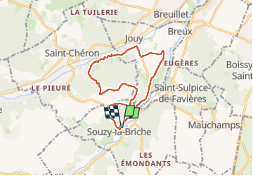
Tocht Stappen van 13,4 km beschikbaar op Île-de-France, Essonne, Souzy-la-Briche. Deze tocht wordt voorgesteld door jchezlemas.
Beschrijving
Rando de Martine et Alain Gauthier
Office de Tourisme de l'Arpajonnais
https://www.ot-coeuressonne.fr/
Plaatsbepaling
Land:
France
Regio :
Île-de-France
Departement/Provincie :
Essonne
Gemeente :
Souzy-la-Briche
Locatie:
Unknown
Vertrek:(Dec)
Vertrek:(UTM)
437190 ; 5375563 (31U) N.
Opmerkingen
Wandeltochten in de omgeving
Les Pétales de Souzy
Stappen
Moeilijk
(1)
Saint-Sulpice-de-Favières,
Île-de-France,
Essonne,
France
4h 49min
Ja
Sur les traces de la Renarde
Te voet
Zeer moeilijk
Saint-Yon,
Île-de-France,
Essonne,
France
38 km | 44 km-effort
10h 4min
Neen
St Sulpice
Stappen
Medium
(1)
Saint-Sulpice-de-Favières,
Île-de-France,
Essonne,
France
8 km | 10,1 km-effort
2h 18min
Ja
Carrière de Madagascar
Stappen
Heel gemakkelijk
(1)
Boissy-sous-Saint-Yon,
Île-de-France,
Essonne,
France
13,2 km | 16,5 km-effort
2h 59min
Ja
Saint-Cheron - l'Orge
Stappen
Medium
Saint-Chéron,
Île-de-France,
Essonne,
France
8,3 km | 10,4 km-effort
2h 21min
Ja
De Saint Chéron à Dourdan par les côteaux de la rive gauche
Stappen
Moeilijk
(1)
Saint-Chéron,
Île-de-France,
Essonne,
France
13,5 km | 17 km-effort
3h 51min
Neen
Villeconin
Stappen
Medium
Villeconin,
Île-de-France,
Essonne,
France
8,5 km | 10,9 km-effort
2h 11min
Ja
Saint-Sulpice-de-Favières
Stappen
Medium
Saint-Sulpice-de-Favières,
Île-de-France,
Essonne,
France
7,5 km | 9,4 km-effort
1h 55min
Ja
Carrières de Madagascar à Souzy-la-Briche
Stappen
Medium
Souzy-la-Briche,
Île-de-France,
Essonne,
France
6,8 km | 8,3 km-effort
1h 52min
Ja