![](/images/other/stat-length.png)
![Tocht Stappen Fontainebleau - Bas Bréau#8 Nord - Photo](https://media.geolcdn.com/t/1900/400/511d41ff-077b-4e95-8c54-f58262625f98.jpg&format=pjpeg&maxdim=2)
Bas Bréau#8 Nord
aubr
Gebruiker
![Lengte](/images/other/stat-length.png)
Lengte
5,2 km
![Max. hoogte](https://static1.geolcdn.com/siteimages/upload/files/1508320355ic_sort_altitude_max_24dp.png)
Max. hoogte
136 m
![Positief hoogteverschil](https://static1.geolcdn.com/siteimages/upload/files/1508320355ic_sort_den_pos_24dp.png)
Positief hoogteverschil
94 m
![Km-Effort](/images/other/stat-length.png)
Km-Effort
6,5 km
![Min. hoogte](https://static1.geolcdn.com/siteimages/upload/files/1508320355ic_sort_altitude_min_24dp.png)
Min. hoogte
88 m
![Negatief hoogteverschil](https://static1.geolcdn.com/siteimages/upload/files/1508320355ic_sort_den_neg_24dp.png)
Negatief hoogteverschil
91 m
![Boucle](https://static1.geolcdn.com/siteimages/upload/files/16400158638029165_repeat_loop_refresh_sync_direction_icon.png)
Boucle
Ja
Datum van aanmaak :
2024-05-21 14:38:29.548
Laatste wijziging :
2024-05-21 17:05:42.969
![Stappen](https://static1.geolcdn.com/sitytour/trail-icons/101.png)
1h28
Moeilijkheid : Medium
![Scan deze QR-code om de tocht te openen in de SityTrail-applicatie](https://capi.geolives.com/qq0zvz2zws4bq2lad0pu/sitytour/trails/4062822/qr.png?size=200)
Gratisgps-wandelapplicatie
Over ons
Tocht Stappen van 5,2 km beschikbaar op Île-de-France, Seine-et-Marne, Fontainebleau. Deze tocht wordt voorgesteld door aubr.
Beschrijving
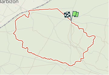
Boucle depuis le Parking du Bas Bréau, Allée des Vaches, Commune de Barbizon.
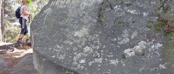
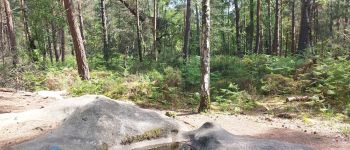
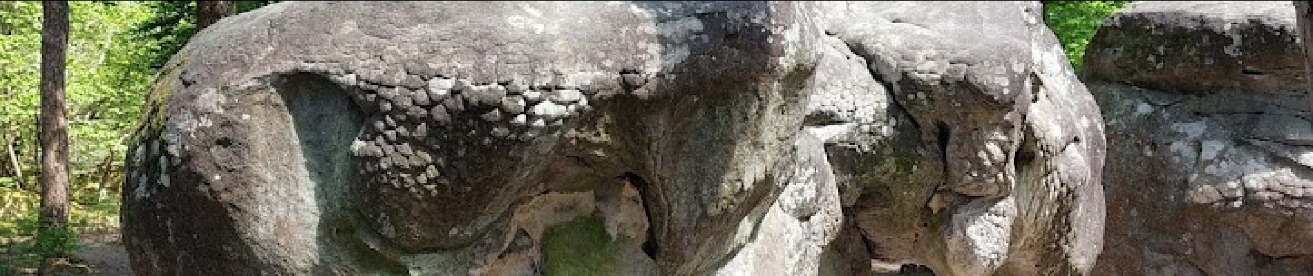
A voir: Chêne Charlemagne, Médaillon Millet et Rousseau, L'éléphant, Grotte Barbizonnière, Points de vue, La caverne des Brigands.
Plaatsbepaling
Land:
France
Regio :
Île-de-France
Departement/Provincie :
Seine-et-Marne
Gemeente :
Fontainebleau
Locatie:
Unknown
Vertrek:(Dec)
Vertrek:(UTM)
472217 ; 5365386 (31U) N.
Opmerkingen
Wandeltochten in de omgeving
![Tocht Stappen Barbizon - Sentier des peintres - Photo](https://media.geolcdn.com/t/375/260/ext.jpg?maxdim=2&url=https%3A%2F%2Fservices.sitytrail.com%2FGeolivesWS%2FDownloadMedia.ashx%3FTrailID%3D188736%26Media%3D187396bd-9ee4-4169-9310-5793d2588587.jpeg)
![Stappen Stappen](https://static1.geolcdn.com/sitytour/trail-icons/101.png)
Sentier des peintres
Stappen
Medium
(11)
Barbizon,
Île-de-France,
Seine-et-Marne,
France
![](/images/other/stat-length.png)
7,5 km | 8,2 km-effort
1h 25min
![](https://static1.geolcdn.com/siteimages/upload/files/16400158638029165_repeat_loop_refresh_sync_direction_icon.png)
Ja
![Tocht Stappen Fontainebleau - Sur les traces de Césaire Sempité - Fontainebleau rocher canon - Photo](https://media.geolcdn.com/t/375/260/b9aa5b48-fd03-4263-8213-67fa0706433b.jpg&format=jpg&maxdim=2)
![Stappen Stappen](https://static1.geolcdn.com/sitytour/trail-icons/101.png)
Sur les traces de Césaire Sempité - Fontainebleau rocher canon
Stappen
Gemakkelijk
(1)
Fontainebleau,
Île-de-France,
Seine-et-Marne,
France
![](/images/other/stat-length.png)
17,3 km | 21 km-effort
4h 8min
![](https://static1.geolcdn.com/siteimages/upload/files/16400158638029165_repeat_loop_refresh_sync_direction_icon.png)
Ja
![Tocht Stappen Fontainebleau - 3pi-150428 - DésertApremont-Jupiter - Photo](https://media.geolcdn.com/t/375/260/ext.jpg?maxdim=2&url=https%3A%2F%2Fservices.sitytrail.com%2FGeolivesWS%2FDownloadMedia.ashx%3FTrailID%3D414037%26Media%3D22942274-9308-46bb-bc6d-06c82c3e8751.jpg)
![Stappen Stappen](https://static1.geolcdn.com/sitytour/trail-icons/101.png)
3pi-150428 - DésertApremont-Jupiter
Stappen
Gemakkelijk
(1)
Fontainebleau,
Île-de-France,
Seine-et-Marne,
France
![](/images/other/stat-length.png)
16 km | 19,4 km-effort
6h 30min
![](https://static1.geolcdn.com/siteimages/upload/files/16400158638029165_repeat_loop_refresh_sync_direction_icon.png)
Ja
![Tocht Stappen Fontainebleau - Boucle Barbizon - Arbonne 26 km - Photo](https://media.geolcdn.com/t/375/260/d3a133ff-ea77-47a6-826a-54bbe45391c4.jpg&format=jpg&maxdim=2)
![Stappen Stappen](https://static1.geolcdn.com/sitytour/trail-icons/101.png)
Boucle Barbizon - Arbonne 26 km
Stappen
Medium
Fontainebleau,
Île-de-France,
Seine-et-Marne,
France
![](/images/other/stat-length.png)
26 km | 30 km-effort
5h 6min
![](https://static1.geolcdn.com/siteimages/upload/files/16400158638029165_repeat_loop_refresh_sync_direction_icon.png)
Ja
![Tocht Te voet Fontainebleau - Fontainebleau les monts de Fay - Photo](https://media.geolcdn.com/t/375/260/44c84e7a-206d-494a-bf60-bcd1709cbc23.jpg&format=jpg&maxdim=2)
![Te voet Te voet](https://static1.geolcdn.com/sitytour/trail-icons/100.png)
Fontainebleau les monts de Fay
Te voet
Medium
Fontainebleau,
Île-de-France,
Seine-et-Marne,
France
![](/images/other/stat-length.png)
22 km | 27 km-effort
6h 12min
![](https://static1.geolcdn.com/siteimages/upload/files/16400158638029165_repeat_loop_refresh_sync_direction_icon.png)
Ja
![Tocht Stappen Fontainebleau - SityTrail - JC 71 Fontainebleau Rocher Cassepot, Tour Denecourt - Photo](https://media.geolcdn.com/t/375/260/ext.jpg?maxdim=2&url=https%3A%2F%2Fstatic1.geolcdn.com%2Fsiteimages%2Fupload%2Ffiles%2F1553511878bg_sport_marche.png)
![Stappen Stappen](https://static1.geolcdn.com/sitytour/trail-icons/101.png)
SityTrail - JC 71 Fontainebleau Rocher Cassepot, Tour Denecourt
Stappen
Moeilijk
(1)
Fontainebleau,
Île-de-France,
Seine-et-Marne,
France
![](/images/other/stat-length.png)
16,9 km | 22 km-effort
4h 55min
![](https://static1.geolcdn.com/siteimages/upload/files/16400158638029165_repeat_loop_refresh_sync_direction_icon.png)
Ja
![Tocht Stappen Fontainebleau - Boucle Fontainebleau - Photo](https://media.geolcdn.com/t/375/260/17f2c6e1-3b09-4e9b-8122-f375fab45f61.jpg&format=jpg&maxdim=2)
![Stappen Stappen](https://static1.geolcdn.com/sitytour/trail-icons/101.png)
Boucle Fontainebleau
Stappen
Medium
Fontainebleau,
Île-de-France,
Seine-et-Marne,
France
![](/images/other/stat-length.png)
29 km | 34 km-effort
5h 49min
![](https://static1.geolcdn.com/siteimages/upload/files/16400158638029165_repeat_loop_refresh_sync_direction_icon.png)
Ja
![Tocht Te voet Fontainebleau - SityTrail - JC 60 Fontainebleau, les rochers du long boyau, du Mt Morillon, des Demoiselles... - Photo](https://media.geolcdn.com/t/375/260/ext.jpg?maxdim=2&url=https%3A%2F%2Fstatic1.geolcdn.com%2Fsiteimages%2Fupload%2Ffiles%2F1545311037marcheuse_200dpi.jpg)
![Te voet Te voet](https://static1.geolcdn.com/sitytour/trail-icons/100.png)
SityTrail - JC 60 Fontainebleau, les rochers du long boyau, du Mt Morillon, d...
Te voet
Moeilijk
(2)
Fontainebleau,
Île-de-France,
Seine-et-Marne,
France
![](/images/other/stat-length.png)
14,6 km | 17,3 km-effort
3h 56min
![](https://static1.geolcdn.com/siteimages/upload/files/16400158638029165_repeat_loop_refresh_sync_direction_icon.png)
Ja
![Tocht Stappen Barbizon - Le tour du Grand Paris via le GR1 etape 14 Barbizon- Malesherbes - Photo](https://media.geolcdn.com/t/375/260/8af1b7ac-6c06-4a51-9474-d487076c1a9a.jpg&format=jpg&maxdim=2)
![Stappen Stappen](https://static1.geolcdn.com/sitytour/trail-icons/101.png)
Le tour du Grand Paris via le GR1 etape 14 Barbizon- Malesherbes
Stappen
Zeer moeilijk
Barbizon,
Île-de-France,
Seine-et-Marne,
France
![](/images/other/stat-length.png)
35 km | 41 km-effort
6h 11min
![](https://static1.geolcdn.com/siteimages/upload/files/16400158638029165_repeat_loop_refresh_sync_direction_icon.png)
Neen
très belle balade