![](/images/other/stat-length.png)
![Tocht Saint-Cirq-Lapopie - 20240422 St Cirq - Vers - Photo](https://media.geolcdn.com/t/1900/400/c7c2d083-3a15-4ad8-8255-9f2c2d891e51.jpg&format=pjpeg&maxdim=2)
20240422 St Cirq - Vers
ThonyM
Gebruiker
![Lengte](/images/other/stat-length.png)
Lengte
22 km
![Max. hoogte](https://static1.geolcdn.com/siteimages/upload/files/1508320355ic_sort_altitude_max_24dp.png)
Max. hoogte
356 m
![Positief hoogteverschil](https://static1.geolcdn.com/siteimages/upload/files/1508320355ic_sort_den_pos_24dp.png)
Positief hoogteverschil
600 m
![Km-Effort](/images/other/stat-length.png)
Km-Effort
31 km
![Min. hoogte](https://static1.geolcdn.com/siteimages/upload/files/1508320355ic_sort_altitude_min_24dp.png)
Min. hoogte
120 m
![Negatief hoogteverschil](https://static1.geolcdn.com/siteimages/upload/files/1508320355ic_sort_den_neg_24dp.png)
Negatief hoogteverschil
693 m
![Boucle](https://static1.geolcdn.com/siteimages/upload/files/16400158638029165_repeat_loop_refresh_sync_direction_icon.png)
Boucle
Neen
Datum van aanmaak :
2024-04-22 06:38:59.0
Laatste wijziging :
2024-04-22 13:44:30.032
![Scan deze QR-code om de tocht te openen in de SityTrail-applicatie](https://capi.geolives.com/qq0zvz2zws4bq2lad0pu/sitytour/trails/4025786/qr.png?size=200)
Gratisgps-wandelapplicatie
Over ons
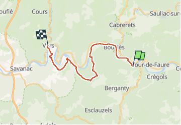
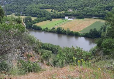
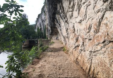
Tocht van 22 km beschikbaar op Occitanië, Lot, Saint-Cirq-Lapopie. Deze tocht wordt voorgesteld door ThonyM.
Beschrijving
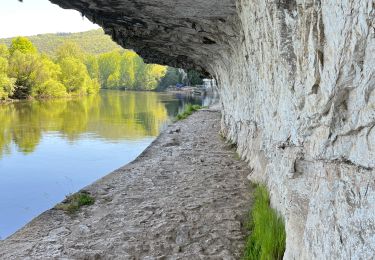
Rester sur le GR évite quelques passages délicats .
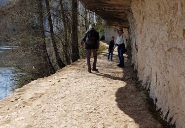
En suivant ce parcours le long du Célé après le chemin de halage cela évite le bitume mais se termine en passage difficile pour certains
Plaatsbepaling
Land:
France
Regio :
Occitanië
Departement/Provincie :
Lot
Gemeente :
Saint-Cirq-Lapopie
Locatie:
Unknown
Vertrek:(Dec)
Vertrek:(UTM)
394073 ; 4924322 (31T) N.
Opmerkingen
Wandeltochten in de omgeving
![Tocht Stappen Saint-Cirq-Lapopie - Circuit sud de St Cirq Lapopie - Photo](https://media.geolcdn.com/t/375/260/ext.jpg?maxdim=2&url=https%3A%2F%2Fservices.sitytrail.com%2FGeolivesWS%2FDownloadMedia.ashx%3FTrailID%3D136873%26Media%3D13540_3.jpg)
![Stappen Stappen](https://static1.geolcdn.com/sitytour/trail-icons/101.png)
Circuit sud de St Cirq Lapopie
Stappen
Moeilijk
(4)
Saint-Cirq-Lapopie,
Occitanië,
Lot,
France
![](/images/other/stat-length.png)
17,7 km | 24 km-effort
3h 30min
![](https://static1.geolcdn.com/siteimages/upload/files/16400158638029165_repeat_loop_refresh_sync_direction_icon.png)
Ja
![Tocht Stappen Bouziès - St Cirq Lapopie - Photo](https://media.geolcdn.com/t/375/260/44c160a2-93bf-4659-a751-61d8e3a0eb0e.jpg&format=jpg&maxdim=2)
![Stappen Stappen](https://static1.geolcdn.com/sitytour/trail-icons/101.png)
St Cirq Lapopie
Stappen
Heel gemakkelijk
(1)
Bouziès,
Occitanië,
Lot,
France
![](/images/other/stat-length.png)
8,3 km | 12,4 km-effort
2h 33min
![](https://static1.geolcdn.com/siteimages/upload/files/16400158638029165_repeat_loop_refresh_sync_direction_icon.png)
Neen
![Tocht Stappen Cabrerets - Etape 3 Cabrenets Bouziès St Cirq Bouziés - Photo](https://media.geolcdn.com/t/375/260/eb50dffb-c87e-4a9e-b7bf-cb556263d54c.jpg&format=jpg&maxdim=2)
![Stappen Stappen](https://static1.geolcdn.com/sitytour/trail-icons/101.png)
Etape 3 Cabrenets Bouziès St Cirq Bouziés
Stappen
Medium
Cabrerets,
Occitanië,
Lot,
France
![](/images/other/stat-length.png)
16,2 km | 24 km-effort
5h 21min
![](https://static1.geolcdn.com/siteimages/upload/files/16400158638029165_repeat_loop_refresh_sync_direction_icon.png)
Neen
![Tocht Stappen Bouziès - Étape 4 Bouziès Les Mazuts - Photo](https://media.geolcdn.com/t/375/260/0fdee0ad-1a12-42b8-a827-ee8edec2f1aa.jpg&format=jpg&maxdim=2)
![Stappen Stappen](https://static1.geolcdn.com/sitytour/trail-icons/101.png)
Étape 4 Bouziès Les Mazuts
Stappen
Moeilijk
Bouziès,
Occitanië,
Lot,
France
![](/images/other/stat-length.png)
21 km | 30 km-effort
6h 29min
![](https://static1.geolcdn.com/siteimages/upload/files/16400158638029165_repeat_loop_refresh_sync_direction_icon.png)
Neen
![Tocht Stappen Cabrerets - Lot CABRERET BEARD - Photo](https://media.geolcdn.com/t/375/260/8fbbbeec-d494-492c-8bdb-b53bc7ff4969.jpg&format=jpg&maxdim=2)
![Stappen Stappen](https://static1.geolcdn.com/sitytour/trail-icons/101.png)
Lot CABRERET BEARD
Stappen
Medium
Cabrerets,
Occitanië,
Lot,
France
![](/images/other/stat-length.png)
24 km | 34 km-effort
4h 44min
![](https://static1.geolcdn.com/siteimages/upload/files/16400158638029165_repeat_loop_refresh_sync_direction_icon.png)
Neen
![Tocht sport Cabrerets - 20240421 Cabrerets - St Cirq - Photo](https://media.geolcdn.com/t/375/260/d84c365c-9ae9-4395-be90-dbc8ee116e29.jpg&format=jpg&maxdim=2)
20240421 Cabrerets - St Cirq
sport
Heel gemakkelijk
Cabrerets,
Occitanië,
Lot,
France
![](/images/other/stat-length.png)
11,6 km | 17,4 km-effort
Onbekend
![](https://static1.geolcdn.com/siteimages/upload/files/16400158638029165_repeat_loop_refresh_sync_direction_icon.png)
Neen
![Tocht Stappen Cabrerets - Cabrerets Liauzu - Photo](https://media.geolcdn.com/t/375/260/9e8b98bf-3708-4f84-b612-7eff50bf29ed.jpg&format=jpg&maxdim=2)
![Stappen Stappen](https://static1.geolcdn.com/sitytour/trail-icons/101.png)
Cabrerets Liauzu
Stappen
Gemakkelijk
Cabrerets,
Occitanië,
Lot,
France
![](/images/other/stat-length.png)
12,3 km | 17,5 km-effort
3h 3min
![](https://static1.geolcdn.com/siteimages/upload/files/16400158638029165_repeat_loop_refresh_sync_direction_icon.png)
Ja
![Tocht Stappen Bouziès - Bouzies St Cirq Conduche - Photo](https://media.geolcdn.com/t/375/260/2aaa2ad3-04a4-48d5-bfb5-10fb0e32fe3f.jpg&format=jpg&maxdim=2)
![Stappen Stappen](https://static1.geolcdn.com/sitytour/trail-icons/101.png)
Bouzies St Cirq Conduche
Stappen
Heel gemakkelijk
Bouziès,
Occitanië,
Lot,
France
![](/images/other/stat-length.png)
15,3 km | 21 km-effort
4h 11min
![](https://static1.geolcdn.com/siteimages/upload/files/16400158638029165_repeat_loop_refresh_sync_direction_icon.png)
Ja
![Tocht Stappen Saint-Cirq-Lapopie - Saint Cirq à Cabrerets - Photo](https://media.geolcdn.com/t/375/260/50464022-d44c-4cf4-ba37-ead935c17100.jpg&format=jpg&maxdim=2)
![Stappen Stappen](https://static1.geolcdn.com/sitytour/trail-icons/101.png)
Saint Cirq à Cabrerets
Stappen
Medium
Saint-Cirq-Lapopie,
Occitanië,
Lot,
France
![](/images/other/stat-length.png)
11,7 km | 17,7 km-effort
3h 40min
![](https://static1.geolcdn.com/siteimages/upload/files/16400158638029165_repeat_loop_refresh_sync_direction_icon.png)
Neen