![](/images/other/stat-length.png)
![Tocht Motor Villars-les-Dombes - Sortie Solex Villars HZD - Photo](https://media.geolcdn.com/t/1900/400/ext.pjpeg?maxdim=2&url=https%3A%2F%2Fstatic1.geolcdn.com%2Fsiteimages%2Fupload%2Ffiles%2F15247431544x4.jpg)
Sortie Solex Villars HZD
BGO
Gebruiker
![Lengte](/images/other/stat-length.png)
Lengte
59 km
![Max. hoogte](https://static1.geolcdn.com/siteimages/upload/files/1508320355ic_sort_altitude_max_24dp.png)
Max. hoogte
300 m
![Positief hoogteverschil](https://static1.geolcdn.com/siteimages/upload/files/1508320355ic_sort_den_pos_24dp.png)
Positief hoogteverschil
461 m
![Km-Effort](/images/other/stat-length.png)
Km-Effort
65 km
![Min. hoogte](https://static1.geolcdn.com/siteimages/upload/files/1508320355ic_sort_altitude_min_24dp.png)
Min. hoogte
238 m
![Negatief hoogteverschil](https://static1.geolcdn.com/siteimages/upload/files/1508320355ic_sort_den_neg_24dp.png)
Negatief hoogteverschil
460 m
![Boucle](https://static1.geolcdn.com/siteimages/upload/files/16400158638029165_repeat_loop_refresh_sync_direction_icon.png)
Boucle
Ja
Datum van aanmaak :
2024-04-17 09:12:59.155
Laatste wijziging :
2024-04-17 09:17:11.424
![Motor](https://static1.geolcdn.com/sitytour/trail-icons/400.png)
0m
Moeilijkheid : Heel gemakkelijk
![Scan deze QR-code om de tocht te openen in de SityTrail-applicatie](https://capi.geolives.com/qq0zvz2zws4bq2lad0pu/sitytour/trails/4019425/qr.png?size=200)
Gratisgps-wandelapplicatie
Over ons
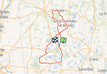
Tocht Motor van 59 km beschikbaar op Auvergne-Rhône-Alpes, Ain, Villars-les-Dombes. Deze tocht wordt voorgesteld door BGO.
Beschrijving
Villars Birieux St Marcel Monthieux Lapeyrouse Bouligneux Beaumont Marlieux Romans St Georges sue Renon St Germain sur Renon Chapelle du Chatelard Villars
Plaatsbepaling
Land:
France
Regio :
Auvergne-Rhône-Alpes
Departement/Provincie :
Ain
Gemeente :
Villars-les-Dombes
Locatie:
Unknown
Vertrek:(Dec)
Vertrek:(UTM)
657228 ; 5096486 (31T) N.
Opmerkingen
Wandeltochten in de omgeving
![Tocht Mountainbike Villars-les-Dombes - 01 vtt Dombes circuit 19 43km 380m 05 2020 - Photo](https://media.geolcdn.com/t/375/260/ee6b40cf-6f68-455c-95fd-46daef6d304b.jpg&format=jpg&maxdim=2)
![Mountainbike Mountainbike](https://static1.geolcdn.com/sitytour/trail-icons/202.png)
01 vtt Dombes circuit 19 43km 380m 05 2020
Mountainbike
Gemakkelijk
Villars-les-Dombes,
Auvergne-Rhône-Alpes,
Ain,
France
![](/images/other/stat-length.png)
44 km | 49 km-effort
3h 19min
![](https://static1.geolcdn.com/siteimages/upload/files/16400158638029165_repeat_loop_refresh_sync_direction_icon.png)
Ja
![Tocht Stappen Le Plantay - ABBAYE Notre-Dame-des-Dombes (18 km - D. 110 m) - Photo](https://media.geolcdn.com/t/375/260/e6fe5bea-e495-4660-8f1e-51eec1e720f3.jpg&format=jpg&maxdim=2)
![Stappen Stappen](https://static1.geolcdn.com/sitytour/trail-icons/101.png)
ABBAYE Notre-Dame-des-Dombes (18 km - D. 110 m)
Stappen
Gemakkelijk
Le Plantay,
Auvergne-Rhône-Alpes,
Ain,
France
![](/images/other/stat-length.png)
18,1 km | 19,6 km-effort
4h 43min
![](https://static1.geolcdn.com/siteimages/upload/files/16400158638029165_repeat_loop_refresh_sync_direction_icon.png)
Ja
![Tocht Motor Villars-les-Dombes - sortie yves pauget 08/2024 - Photo](https://media.geolcdn.com/t/375/260/ext.jpg?maxdim=2&url=https%3A%2F%2Fstatic1.geolcdn.com%2Fsiteimages%2Fupload%2Ffiles%2F15247431544x4.jpg)
![Motor Motor](https://static1.geolcdn.com/sitytour/trail-icons/400.png)
sortie yves pauget 08/2024
Motor
Heel gemakkelijk
Villars-les-Dombes,
Auvergne-Rhône-Alpes,
Ain,
France
![](/images/other/stat-length.png)
64 km | 72 km-effort
Onbekend
![](https://static1.geolcdn.com/siteimages/upload/files/16400158638029165_repeat_loop_refresh_sync_direction_icon.png)
Ja
![Tocht Stappen Bouligneux - Bouligneux-Etang de la petite Bozonnière-Ain - Photo](https://media.geolcdn.com/t/375/260/ext.jpg?maxdim=2&url=https%3A%2F%2Fstatic1.geolcdn.com%2Fsiteimages%2Fupload%2Ffiles%2F1553511878bg_sport_marche.png)
![Stappen Stappen](https://static1.geolcdn.com/sitytour/trail-icons/101.png)
Bouligneux-Etang de la petite Bozonnière-Ain
Stappen
Medium
Bouligneux,
Auvergne-Rhône-Alpes,
Ain,
France
![](/images/other/stat-length.png)
7 km | 7,6 km-effort
1h 43min
![](https://static1.geolcdn.com/siteimages/upload/files/16400158638029165_repeat_loop_refresh_sync_direction_icon.png)
Ja
![Tocht Fiets Villars-les-Dombes - ain en velo circuit 19 - Photo](https://media.geolcdn.com/t/375/260/ext.jpg?maxdim=2&url=https%3A%2F%2Fstatic1.geolcdn.com%2Fsiteimages%2Fupload%2Ffiles%2F1524743154velo.jpg)
![Fiets Fiets](https://static1.geolcdn.com/sitytour/trail-icons/200.png)
ain en velo circuit 19
Fiets
Heel gemakkelijk
Villars-les-Dombes,
Auvergne-Rhône-Alpes,
Ain,
France
![](/images/other/stat-length.png)
43 km | 48 km-effort
2h 46min
![](https://static1.geolcdn.com/siteimages/upload/files/16400158638029165_repeat_loop_refresh_sync_direction_icon.png)
Ja
![Tocht Fiets Villars-les-Dombes - ain en velo circuit 19 - Photo](https://media.geolcdn.com/t/375/260/ext.jpg?maxdim=2&url=https%3A%2F%2Fstatic1.geolcdn.com%2Fsiteimages%2Fupload%2Ffiles%2F1524743154velo.jpg)
![Fiets Fiets](https://static1.geolcdn.com/sitytour/trail-icons/200.png)
ain en velo circuit 19
Fiets
Heel gemakkelijk
Villars-les-Dombes,
Auvergne-Rhône-Alpes,
Ain,
France
![](/images/other/stat-length.png)
43 km | 48 km-effort
Onbekend
![](https://static1.geolcdn.com/siteimages/upload/files/16400158638029165_repeat_loop_refresh_sync_direction_icon.png)
Ja
![Tocht Stappen Bouligneux - Les étangs de Bouligneux - Photo](https://media.geolcdn.com/t/375/260/ext.jpg?maxdim=2&url=https%3A%2F%2Fstatic1.geolcdn.com%2Fsiteimages%2Fupload%2Ffiles%2F1553511878bg_sport_marche.png)
![Stappen Stappen](https://static1.geolcdn.com/sitytour/trail-icons/101.png)
Les étangs de Bouligneux
Stappen
Gemakkelijk
(3)
Bouligneux,
Auvergne-Rhône-Alpes,
Ain,
France
![](/images/other/stat-length.png)
7,2 km | 7,8 km-effort
4h 0min
![](https://static1.geolcdn.com/siteimages/upload/files/16400158638029165_repeat_loop_refresh_sync_direction_icon.png)
Ja
![Tocht sport Villars-les-Dombes - 2025-02-07_17h25m09_LYONETREGION_VELO_06_VoyageVelo_Dombes - Photo](https://media.geolcdn.com/t/375/260/ext.jpg?maxdim=2&url=https%3A%2F%2Fsecurestorage.geolives.com%2Fsitytour%2Ftrail-bg%2Fdefault.jpg)
2025-02-07_17h25m09_LYONETREGION_VELO_06_VoyageVelo_Dombes
sport
Heel gemakkelijk
Villars-les-Dombes,
Auvergne-Rhône-Alpes,
Ain,
France
![](/images/other/stat-length.png)
157 km | 175 km-effort
Onbekend
![](https://static1.geolcdn.com/siteimages/upload/files/16400158638029165_repeat_loop_refresh_sync_direction_icon.png)
Neen
![Tocht sport Villars-les-Dombes - Parc oiseaux Villars - Photo](https://media.geolcdn.com/t/375/260/ext.jpg?maxdim=2&url=https%3A%2F%2Fsecurestorage.geolives.com%2Fsitytour%2Ftrail-bg%2Fdefault.jpg)
Parc oiseaux Villars
sport
Heel gemakkelijk
Villars-les-Dombes,
Auvergne-Rhône-Alpes,
Ain,
France
![](/images/other/stat-length.png)
3,9 km | 4,1 km-effort
Onbekend
![](https://static1.geolcdn.com/siteimages/upload/files/16400158638029165_repeat_loop_refresh_sync_direction_icon.png)
Ja