![](/images/other/stat-length.png)
![Tocht Te voet Gréoux-les-Bains - Les Tronnes n°3 - Photo](https://media.geolcdn.com/t/1900/400/ext.pjpeg?maxdim=2&url=https%3A%2F%2Fstatic1.geolcdn.com%2Fsiteimages%2Fupload%2Ffiles%2F1545311037marcheuse_200dpi.jpg)
Les Tronnes n°3
aubr
Gebruiker
![Lengte](/images/other/stat-length.png)
Lengte
6,5 km
![Max. hoogte](https://static1.geolcdn.com/siteimages/upload/files/1508320355ic_sort_altitude_max_24dp.png)
Max. hoogte
449 m
![Positief hoogteverschil](https://static1.geolcdn.com/siteimages/upload/files/1508320355ic_sort_den_pos_24dp.png)
Positief hoogteverschil
166 m
![Km-Effort](/images/other/stat-length.png)
Km-Effort
8,7 km
![Min. hoogte](https://static1.geolcdn.com/siteimages/upload/files/1508320355ic_sort_altitude_min_24dp.png)
Min. hoogte
298 m
![Negatief hoogteverschil](https://static1.geolcdn.com/siteimages/upload/files/1508320355ic_sort_den_neg_24dp.png)
Negatief hoogteverschil
167 m
![Boucle](https://static1.geolcdn.com/siteimages/upload/files/16400158638029165_repeat_loop_refresh_sync_direction_icon.png)
Boucle
Ja
Datum van aanmaak :
2024-04-16 12:49:59.253
Laatste wijziging :
2024-04-16 14:15:09.469
![Te voet](https://static1.geolcdn.com/sitytour/trail-icons/100.png)
1h59
Moeilijkheid : Gemakkelijk
![Scan deze QR-code om de tocht te openen in de SityTrail-applicatie](https://capi.geolives.com/qq0zvz2zws4bq2lad0pu/sitytour/trails/4018559/qr.png?size=200)
Gratisgps-wandelapplicatie
Over ons
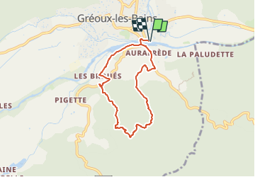
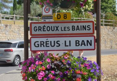
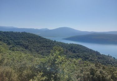
Tocht Te voet van 6,5 km beschikbaar op Provence-Alpes-Côte d'Azur, Alpes-de-Haute-Provence, Gréoux-les-Bains. Deze tocht wordt voorgesteld door aubr.
Beschrijving
Circuit de l'OT
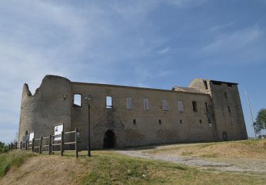
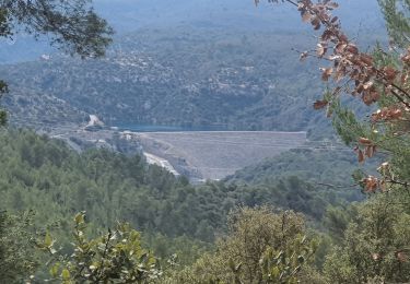
Boucle de 6,5 Km au départ du parking au bord du Verdon.
Traverser le Verdon puis suivre la Buissière, les Tronnes, les Broues, la Digue, le pont du Verdon.
Plaatsbepaling
Land:
France
Regio :
Provence-Alpes-Côte d'Azur
Departement/Provincie :
Alpes-de-Haute-Provence
Gemeente :
Gréoux-les-Bains
Locatie:
Unknown
Vertrek:(Dec)
Vertrek:(UTM)
732838 ; 4848615 (31T) N.
Opmerkingen
Wandeltochten in de omgeving
![Stappen Stappen](https://static1.geolcdn.com/sitytour/trail-icons/101.png)
20220612 - Gréoux les Bains - Découverte
Stappen
Medium
(1)
Gréoux-les-Bains,
Provence-Alpes-Côte d'Azur,
Alpes-de-Haute-Provence,
France
![](/images/other/stat-length.png)
6,2 km | 7,8 km-effort
2h 5min
![](https://static1.geolcdn.com/siteimages/upload/files/16400158638029165_repeat_loop_refresh_sync_direction_icon.png)
Ja
![Tocht Mountainbike Gréoux-les-Bains - De Gréoux les Bains au Lac d'Esparron - Photo](https://media.geolcdn.com/t/375/260/ext.jpg?maxdim=2&url=https%3A%2F%2Fservices.sitytrail.com%2FGeolivesWS%2FDownloadMedia.ashx%3FTrailID%3D129876%26Media%3D13444_1.jpg)
![Mountainbike Mountainbike](https://static1.geolcdn.com/sitytour/trail-icons/202.png)
De Gréoux les Bains au Lac d'Esparron
Mountainbike
Medium
(2)
Gréoux-les-Bains,
Provence-Alpes-Côte d'Azur,
Alpes-de-Haute-Provence,
France
![](/images/other/stat-length.png)
22 km | 30 km-effort
2h 0min
![](https://static1.geolcdn.com/siteimages/upload/files/16400158638029165_repeat_loop_refresh_sync_direction_icon.png)
Ja
![Tocht Stappen Saint-Julien - 2022-11-11 Balcon de Saint Julien au lac d'Esparon - Photo](https://media.geolcdn.com/t/375/260/62e038c3-e228-4ae0-bf51-fb91477c57ba.jpg&format=jpg&maxdim=2)
![Stappen Stappen](https://static1.geolcdn.com/sitytour/trail-icons/101.png)
2022-11-11 Balcon de Saint Julien au lac d'Esparon
Stappen
Medium
Saint-Julien,
Provence-Alpes-Côte d'Azur,
Var,
France
![](/images/other/stat-length.png)
16,9 km | 23 km-effort
4h 5min
![](https://static1.geolcdn.com/siteimages/upload/files/16400158638029165_repeat_loop_refresh_sync_direction_icon.png)
Ja
![Stappen Stappen](https://static1.geolcdn.com/sitytour/trail-icons/101.png)
20220617 - Gréoux 6.5 Km
Stappen
Medium
Gréoux-les-Bains,
Provence-Alpes-Côte d'Azur,
Alpes-de-Haute-Provence,
France
![](/images/other/stat-length.png)
6,5 km | 7,9 km-effort
2h 0min
![](https://static1.geolcdn.com/siteimages/upload/files/16400158638029165_repeat_loop_refresh_sync_direction_icon.png)
Ja
![Stappen Stappen](https://static1.geolcdn.com/sitytour/trail-icons/101.png)
20220616 - Gréoux-les-Bains - Visite château
Stappen
Medium
Gréoux-les-Bains,
Provence-Alpes-Côte d'Azur,
Alpes-de-Haute-Provence,
France
![](/images/other/stat-length.png)
6,9 km | 9 km-effort
2h 34min
![](https://static1.geolcdn.com/siteimages/upload/files/16400158638029165_repeat_loop_refresh_sync_direction_icon.png)
Ja
![Tocht Stappen Gréoux-les-Bains - 08-04-2022 Gréoux - Les Maurras - Photo](https://media.geolcdn.com/t/375/260/3f4d635a-05b2-45c2-b069-140ff93f8fb8.jpg&format=jpg&maxdim=2)
![Stappen Stappen](https://static1.geolcdn.com/sitytour/trail-icons/101.png)
08-04-2022 Gréoux - Les Maurras
Stappen
Gemakkelijk
Gréoux-les-Bains,
Provence-Alpes-Côte d'Azur,
Alpes-de-Haute-Provence,
France
![](/images/other/stat-length.png)
15,2 km | 21 km-effort
3h 43min
![](https://static1.geolcdn.com/siteimages/upload/files/16400158638029165_repeat_loop_refresh_sync_direction_icon.png)
Ja
![Tocht Stappen Gréoux-les-Bains - 06-04-2022 Gréoux - St Martin de Brômes - Photo](https://media.geolcdn.com/t/375/260/f105afad-45ad-4f2e-b245-baf7142bb320.jpg&format=jpg&maxdim=2)
![Stappen Stappen](https://static1.geolcdn.com/sitytour/trail-icons/101.png)
06-04-2022 Gréoux - St Martin de Brômes
Stappen
Moeilijk
Gréoux-les-Bains,
Provence-Alpes-Côte d'Azur,
Alpes-de-Haute-Provence,
France
![](/images/other/stat-length.png)
13,8 km | 19,2 km-effort
3h 44min
![](https://static1.geolcdn.com/siteimages/upload/files/16400158638029165_repeat_loop_refresh_sync_direction_icon.png)
Ja
![Tocht Mountainbike Gréoux-les-Bains - VTT Single spirit - Gréoux les Bains - Photo](https://media.geolcdn.com/t/375/260/ext.jpg?maxdim=2&url=https%3A%2F%2Fstatic1.geolcdn.com%2Fsiteimages%2Fupload%2Ffiles%2F1524743154velo.jpg)
![Mountainbike Mountainbike](https://static1.geolcdn.com/sitytour/trail-icons/202.png)
VTT Single spirit - Gréoux les Bains
Mountainbike
Moeilijk
(2)
Gréoux-les-Bains,
Provence-Alpes-Côte d'Azur,
Alpes-de-Haute-Provence,
France
![](/images/other/stat-length.png)
18,2 km | 25 km-effort
1h 30min
![](https://static1.geolcdn.com/siteimages/upload/files/16400158638029165_repeat_loop_refresh_sync_direction_icon.png)
Ja
![Tocht Elektrische fiets Esparron-de-Verdon - Espérons Ste Croix et retour - Photo](https://media.geolcdn.com/t/375/260/38155cb3-abc4-4bcf-9e58-4f4b9734ae23.jpg&format=jpg&maxdim=2)
![Elektrische fiets Elektrische fiets](https://static1.geolcdn.com/sitytour/trail-icons/205.png)
Espérons Ste Croix et retour
Elektrische fiets
Medium
Esparron-de-Verdon,
Provence-Alpes-Côte d'Azur,
Alpes-de-Haute-Provence,
France
![](/images/other/stat-length.png)
74 km | 90 km-effort
3h 29min
![](https://static1.geolcdn.com/siteimages/upload/files/16400158638029165_repeat_loop_refresh_sync_direction_icon.png)
Neen