Tocht Stappen Thièvres - THIEVRES - Circuit de l'arbre de Cocagne - Photo

THIEVRES - Circuit de l'arbre de Cocagne

 temmichel
temmichel

Gebruiker

© OpenStreetMap contributors
Lengte
Lengte
8,8 km
Max. hoogte
Max. hoogte
149 m
Positief hoogteverschil
140 m
Km-Effort
Km-Effort  
10,6 km
Min. hoogte
Min. hoogte
74 m
Negatief hoogteverschil
139 m
Boucle
Boucle
Ja
Datum van aanmaak :
2024-04-11 12:47:44.756
Laatste wijziging :
2024-04-11 13:00:28.106

(0 Bericht)

Stappen
Stappen
2h24
Moeilijkheid : Medium

Scan deze QR-code om de tocht te openen in de SityTrail-applicatie

Gratisgps-wandelapplicatie

Logo SityTrail SityTrail

IGN / Geografische instituten

SityTrail uit de App Store downloaden SityTrail uit Google Play downloaden

Logo SityTrail SityTrail World

De wereld gaat voor u open

SityTrail uit de App Store downloaden SityTrail uit Google Play downloaden SityTrail op Huawei AppGallery downloaden

Over ons

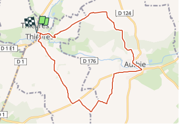
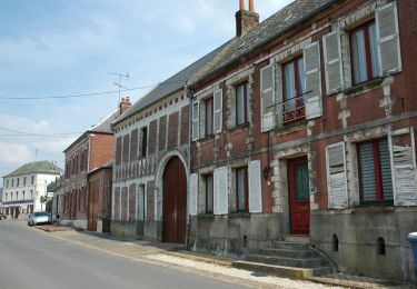
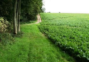
Tocht Stappen van 8,8 km beschikbaar op Hauts-de-France, Pas-de-Calais, Thièvres. Deze tocht wordt voorgesteld door temmichel.

Beschrijving

Randonnée qui vous conduira de part et d'autre de l'Authies en parcourant le GR 124 A titre d'information le GR 124 débute à CIRE LES MELO dans l'Oise et rejoint le GR 121 à REBREUVIETTE dans le Pas-de-Calais pour une longueur de 222 kms
Bonne randonnée
Jean-Michel

Hoogteprofiel

Foto's

Plaatsbepaling

Land:
France
Regio :
Hauts-de-France
Departement/Provincie :
Pas-de-Calais
Gemeente :
Thièvres
Locatie:
Unknown
Vertrek:(UTM)
460999 ; 5553076 (31U) N.

Wandeltochten in de omgeving

Tocht Te voet Vauchelles-lès-Authie - Circuit du Pigeonnier au Moulin - Photo
Te voet
GUIDE+

Te voet

Gemakkelijk
Vauchelles-lès-Authie, Hauts-de-France, Somme, France
6,8 km | 7,7 km-effort
1h 44min
Ja
Tocht Te voet Authie - Autour du Prieuré d'Authie - Photo
Te voet
GUIDE+

Te voet

Gemakkelijk
Authie, Hauts-de-France, Somme, France
10 km | 11,8 km-effort
2h 41min
Ja
Tocht Stappen Thièvres - Sentier de la montagne - Thièvres - Photo
Stappen
tracegps

Stappen

Medium
Thièvres, Hauts-de-France, Somme, France
8,7 km | 10,1 km-effort
2h 10min
Ja
Tocht Stappen Thièvres - Sentier du Fay - Grand-Rullecourt - Photo
Stappen
tracegps

Stappen

Zeer moeilijk
Thièvres, Hauts-de-France, Somme, France
8,7 km | 10,1 km-effort
4h 25min
Ja
Tocht Stappen Pas-en-Artois - Sentier des Bois - Pas-en-Artois - Photo
Stappen
tracegps

Stappen

Medium
Pas-en-Artois, Hauts-de-France, Pas-de-Calais, France
8,7 km | 10,7 km-effort
2h 10min
Ja
Tocht Stappen Beauquesne - Le Tortillard (variante courte) - Photo
Stappen
tracegps

Stappen

Medium
Beauquesne, Hauts-de-France, Somme, France
8,7 km | 9,7 km-effort
2h 30min
Ja
Tocht Stappen Authie - Autour du Prieuré d'Authie - Photo
Stappen
tracegps

Stappen

Medium
(1)
Authie, Hauts-de-France, Somme, France
10,1 km | 12 km-effort
3h 19min
Ja
Tocht Stappen Beauquesne - Le Tortillard - Photo
Stappen
tracegps

Stappen

Medium
Beauquesne, Hauts-de-France, Somme, France
11,7 km | 13,2 km-effort
4h 0min
Ja
Tocht Stappen Thièvres - kjv - Photo
Stappen
a.catteau

Stappen

Heel gemakkelijk
Thièvres, Hauts-de-France, Somme, France
9 km | 10,4 km-effort
2h 39min
Ja


Sluiten
Mijn abonnementen