![](/images/other/stat-length.png)
![Tocht Stappen Castelnau-d'Aude - 11-Castelnau d'Aude (Aude) - Photo](https://media.geolcdn.com/t/1900/400/ext.pjpeg?maxdim=2&url=https%3A%2F%2Fstatic1.geolcdn.com%2Fsiteimages%2Fupload%2Ffiles%2F1553511878bg_sport_marche.png)
11-Castelnau d'Aude (Aude)
Jovila
Gebruiker
![Lengte](/images/other/stat-length.png)
Lengte
5,7 km
![Max. hoogte](https://static1.geolcdn.com/siteimages/upload/files/1508320355ic_sort_altitude_max_24dp.png)
Max. hoogte
105 m
![Positief hoogteverschil](https://static1.geolcdn.com/siteimages/upload/files/1508320355ic_sort_den_pos_24dp.png)
Positief hoogteverschil
82 m
![Km-Effort](/images/other/stat-length.png)
Km-Effort
6,7 km
![Min. hoogte](https://static1.geolcdn.com/siteimages/upload/files/1508320355ic_sort_altitude_min_24dp.png)
Min. hoogte
59 m
![Negatief hoogteverschil](https://static1.geolcdn.com/siteimages/upload/files/1508320355ic_sort_den_neg_24dp.png)
Negatief hoogteverschil
81 m
![Boucle](https://static1.geolcdn.com/siteimages/upload/files/16400158638029165_repeat_loop_refresh_sync_direction_icon.png)
Boucle
Ja
Datum van aanmaak :
2017-02-24 00:00:00.0
Laatste wijziging :
2017-02-24 00:00:00.0
![Stappen](https://static1.geolcdn.com/sitytour/trail-icons/101.png)
1h22
Moeilijkheid : Heel gemakkelijk
![Scan deze QR-code om de tocht te openen in de SityTrail-applicatie](https://capi.geolives.com/qq0zvz2zws4bq2lad0pu/sitytour/trails/400343/qr.png?size=200)
Gratisgps-wandelapplicatie
Over ons
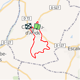
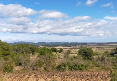
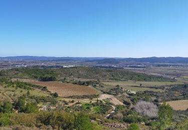
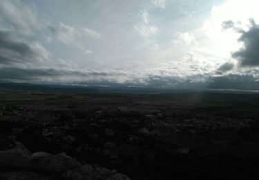
Tocht Stappen van 5,7 km beschikbaar op Occitanië, Aude, Castelnau-d'Aude. Deze tocht wordt voorgesteld door Jovila.
Beschrijving
Randonnée très bien balisée.
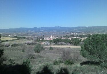
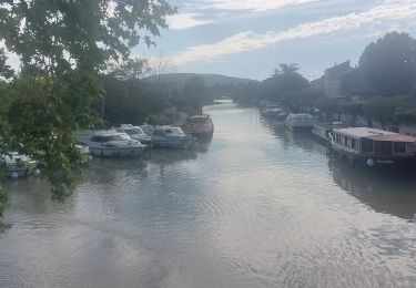
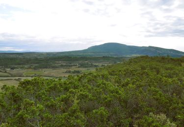
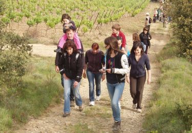
Panneau d'indications au départ (durée de la rando 2 h 30), nous l'avons effectuée en 1 h 20 en visitant la chapelle au cimetière et en prenant des photos !!!!
Plaatsbepaling
Land:
France
Regio :
Occitanië
Departement/Provincie :
Aude
Gemeente :
Castelnau-d'Aude
Locatie:
Unknown
Vertrek:(Dec)
Vertrek:(UTM)
473424 ; 4786384 (31T) N.
Opmerkingen
Wandeltochten in de omgeving
![Tocht Stappen Tourouzelle - 11-Tourouzelle la Pinède de la Bade - 23/02/2014 - Photo](https://media.geolcdn.com/t/375/260/ext.jpg?maxdim=2&url=https%3A%2F%2Fservices.sitytrail.com%2FGeolivesWS%2FDownloadMedia.ashx%3FTrailID%3D252416%26Media%3Dfix__20140223114729.jpg)
![Stappen Stappen](https://static1.geolcdn.com/sitytour/trail-icons/101.png)
11-Tourouzelle la Pinède de la Bade - 23/02/2014
Stappen
Gemakkelijk
(2)
Tourouzelle,
Occitanië,
Aude,
France
![](/images/other/stat-length.png)
9,7 km | 11,9 km-effort
2h 29min
![](https://static1.geolcdn.com/siteimages/upload/files/16400158638029165_repeat_loop_refresh_sync_direction_icon.png)
Ja
![Tocht Stappen Montbrun-des-Corbières - Montbrun - Photo](https://media.geolcdn.com/t/375/260/ext.jpg?maxdim=2&url=https%3A%2F%2Fstatic1.geolcdn.com%2Fsiteimages%2Fupload%2Ffiles%2F1553511878bg_sport_marche.png)
![Stappen Stappen](https://static1.geolcdn.com/sitytour/trail-icons/101.png)
Montbrun
Stappen
Heel gemakkelijk
(1)
Montbrun-des-Corbières,
Occitanië,
Aude,
France
![](/images/other/stat-length.png)
9,3 km | 11,6 km-effort
2h 21min
![](https://static1.geolcdn.com/siteimages/upload/files/16400158638029165_repeat_loop_refresh_sync_direction_icon.png)
Ja
![Tocht Stappen Montbrun-des-Corbières - MONTBRUN DES CORBIERES rocher du renard - Photo](https://media.geolcdn.com/t/375/260/ext.jpg?maxdim=2&url=https%3A%2F%2Fmedia.geolcdn.com%2Ff%2Fd02e827b-6ff3-45e9-b3e2-482015f52b57.JPG)
![Stappen Stappen](https://static1.geolcdn.com/sitytour/trail-icons/101.png)
MONTBRUN DES CORBIERES rocher du renard
Stappen
Gemakkelijk
Montbrun-des-Corbières,
Occitanië,
Aude,
France
![](/images/other/stat-length.png)
7,4 km | 9,3 km-effort
1h 30min
![](https://static1.geolcdn.com/siteimages/upload/files/16400158638029165_repeat_loop_refresh_sync_direction_icon.png)
Ja
![Tocht Stappen Escales - ESCALES - La tour Romane - Photo](https://media.geolcdn.com/t/375/260/ext.jpg?maxdim=2&url=https%3A%2F%2Fmedia.geolcdn.com%2Ff%2Fdfcd4544-fef2-456a-b32a-8ca1903f77b4.jpg)
![Stappen Stappen](https://static1.geolcdn.com/sitytour/trail-icons/101.png)
ESCALES - La tour Romane
Stappen
Heel gemakkelijk
(1)
Escales,
Occitanië,
Aude,
France
![](/images/other/stat-length.png)
4,2 km | 5,6 km-effort
1h 5min
![](https://static1.geolcdn.com/siteimages/upload/files/16400158638029165_repeat_loop_refresh_sync_direction_icon.png)
Ja
![Tocht Stappen Conilhac-Corbières - CONILHAC Les Eoliennes - Photo](https://media.geolcdn.com/t/375/260/ext.jpg?maxdim=2&url=https%3A%2F%2Fmedia.geolcdn.com%2Ff%2F61a6f362-e725-47d8-be5f-e8d8f9b00380.jpg)
![Stappen Stappen](https://static1.geolcdn.com/sitytour/trail-icons/101.png)
CONILHAC Les Eoliennes
Stappen
Heel gemakkelijk
(1)
Conilhac-Corbières,
Occitanië,
Aude,
France
![](/images/other/stat-length.png)
7,4 km | 9,5 km-effort
1h 27min
![](https://static1.geolcdn.com/siteimages/upload/files/16400158638029165_repeat_loop_refresh_sync_direction_icon.png)
Ja
![Tocht Stappen Conilhac-Corbières - CONILHAC - lausines - Photo](https://media.geolcdn.com/t/375/260/ext.jpg?maxdim=2&url=https%3A%2F%2Fmedia.geolcdn.com%2Ff%2Feabb2449-16e0-4bf7-bb9c-bc1f8dc0926e.jpg)
![Stappen Stappen](https://static1.geolcdn.com/sitytour/trail-icons/101.png)
CONILHAC - lausines
Stappen
Heel gemakkelijk
Conilhac-Corbières,
Occitanië,
Aude,
France
![](/images/other/stat-length.png)
4,8 km | 6,6 km-effort
1h 31min
![](https://static1.geolcdn.com/siteimages/upload/files/16400158638029165_repeat_loop_refresh_sync_direction_icon.png)
Ja
![Tocht Fiets Homps - CanalduMidi_Minerve - Photo](https://media.geolcdn.com/t/375/260/ext.jpg?maxdim=2&url=https%3A%2F%2Fstatic1.geolcdn.com%2Fsiteimages%2Fupload%2Ffiles%2F1524743154velo.jpg)
![Fiets Fiets](https://static1.geolcdn.com/sitytour/trail-icons/200.png)
CanalduMidi_Minerve
Fiets
Medium
(1)
Homps,
Occitanië,
Aude,
France
![](/images/other/stat-length.png)
41 km | 47 km-effort
2h 43min
![](https://static1.geolcdn.com/siteimages/upload/files/16400158638029165_repeat_loop_refresh_sync_direction_icon.png)
Neen
![Tocht Stappen Castelnau-d'Aude - En Corbières - Le Bosquet - Castelnau d'Aude - Photo](https://media.geolcdn.com/t/375/260/ext.jpg?maxdim=2&url=https%3A%2F%2Fservices.sitytrail.com%2FGeolivesWS%2FDownloadMedia.ashx%3FTrailID%3D172655%26Media%3D14026_3.jpg)
![Stappen Stappen](https://static1.geolcdn.com/sitytour/trail-icons/101.png)
En Corbières - Le Bosquet - Castelnau d'Aude
Stappen
Medium
Castelnau-d'Aude,
Occitanië,
Aude,
France
![](/images/other/stat-length.png)
4,8 km | 5,8 km-effort
2h 30min
![](https://static1.geolcdn.com/siteimages/upload/files/16400158638029165_repeat_loop_refresh_sync_direction_icon.png)
Ja
![Tocht Stappen Saint-Couat-d'Aude - Reco Officielle Marche RED'S 15.10.2022 - Photo](https://media.geolcdn.com/t/375/260/ext.jpg?maxdim=2&url=https%3A%2F%2Fmedia.geolcdn.com%2Ff%2F8c597725-8c8e-4b05-a2d8-2af91cb71b28.jpg)
![Stappen Stappen](https://static1.geolcdn.com/sitytour/trail-icons/101.png)
Reco Officielle Marche RED'S 15.10.2022
Stappen
Zeer moeilijk
(1)
Saint-Couat-d'Aude,
Occitanië,
Aude,
France
![](/images/other/stat-length.png)
25 km | 34 km-effort
7h 44min
![](https://static1.geolcdn.com/siteimages/upload/files/16400158638029165_repeat_loop_refresh_sync_direction_icon.png)
Ja