Tocht Stappen Villers-la-Ville - #240322 - Tilly, Gentissart - Photo

#240322 - Tilly, Gentissart

 Randos Ouvertes
Randos Ouvertes

Gebruiker

© OpenStreetMap contributors
Lengte
Lengte
6,9 km
Max. hoogte
Max. hoogte
158 m
Positief hoogteverschil
95 m
Km-Effort
Km-Effort  
8,2 km
Min. hoogte
Min. hoogte
111 m
Negatief hoogteverschil
95 m
Boucle
Boucle
Ja
Datum van aanmaak :
2024-03-21 16:50:10.738
Laatste wijziging :
2024-03-24 10:54:18.727

(0 Bericht)

Stappen
Stappen
1h51
Moeilijkheid : Medium

Scan deze QR-code om de tocht te openen in de SityTrail-applicatie

Gratisgps-wandelapplicatie

Logo SityTrail SityTrail

IGN / Geografische instituten

SityTrail uit de App Store downloaden SityTrail uit Google Play downloaden

Logo SityTrail SityTrail World

De wereld gaat voor u open

SityTrail uit de App Store downloaden SityTrail uit Google Play downloaden SityTrail op Huawei AppGallery downloaden

Over ons

Tocht Stappen van 6,9 km beschikbaar op Wallonië, Waals-Brabant, Villers-la-Ville. Deze tocht wordt voorgesteld door Randos Ouvertes.

Beschrijving

Circuit contratsté mi-village, mi nature traversant pendant près de 2 km le haut plateau de Gentissart qui culmine à 160 m, vue à 360°.
Passage le long de l'ancienne sablière devenue en 1989 la tristement célèbre décharge de Mellery.

Le site a été réhabilité par la SPAQUE.
On y distingue les tuyauteries de dégazage qui alimentent une unité de filtration.

Crédit photos : Corinne van Aubel, Sophie Vermote et Béatrice Walsdorff

Hoogteprofiel

Foto's

Plaatsbepaling

Land:
Belgium
Regio :
Wallonië
Departement/Provincie :
Waals-Brabant
Gemeente :
Villers-la-Ville
Locatie:
Unknown
Vertrek:(Dec)
Vertrek:(UTM)
609901 ; 5602102 (31U) N.

Wandeltochten in de omgeving

Tocht Stappen Villers-la-Ville - RB-Bw-10-raccourci 2 - À travers campagnes et forêts, autour des ruines d’une prestigieuse abbaye - Photo
Stappen
PRO

Stappen

Moeilijk
(25)
Villers-la-Ville, Wallonië, Waals-Brabant, Belgium
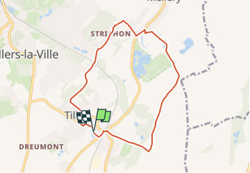
13,3 km | 16,4 km-effort
3h 44min
Ja
Tocht Stappen Villers-la-Ville - RB-Bw-10-raccourci 1 - À travers campagnes et forêts, autour des ruines d’une prestigieuse abbaye  - Photo
Stappen
PRO

Stappen

Zeer moeilijk
(12)
Villers-la-Ville, Wallonië, Waals-Brabant, Belgium
24 km | 30 km-effort
6h 43min
Ja
Tocht Stappen Villers-la-Ville - RB-Bw-10 -À travers campagnes et forêts, autour des ruines d’une prestigieuse abbaye  - Photo
Stappen
PRO

Stappen

Zeer moeilijk
(6)
Villers-la-Ville, Wallonië, Waals-Brabant, Belgium
26 km | 32 km-effort
7h 15min
Ja
Tocht Stappen Genepiën - Genappe - Circuit Natura 2000, des sites qui valent le détour ! - Bw03 - Photo
Stappen
GUIDE+

Stappen

Medium
(6)
Genepiën, Wallonië, Waals-Brabant, Belgium
7,9 km | 9,7 km-effort
2h 6min
Ja
Tocht Stappen Villers-la-Ville - Balade forestière à Villers la Ville - Photo
Stappen
GUIDE
Desrumaux

Stappen

Gemakkelijk
(5)
Villers-la-Ville, Wallonië, Waals-Brabant, Belgium
11,5 km | 14,1 km-effort
3h 0min
Ja
Tocht Stappen Chastre - #230728 - Gentinnes Kongolo - Photo
Stappen
Randos Ouvertes

Stappen

Gemakkelijk
(1)
Chastre, Wallonië, Waals-Brabant, Belgium
5 km | 5,6 km-effort
1h 16min
Ja
Tocht Stappen Villers-la-Ville - BE-Villers-la-Ville - Le Bois Pigeolet et le Châtelet - VLV 7  - Photo
Stappen
MicDul

Stappen

Gemakkelijk
(1)
Villers-la-Ville, Wallonië, Waals-Brabant, Belgium
6,6 km | 7,8 km-effort
1h 42min
Ja
Tocht Stappen Villers-la-Ville - #190324 - Rigenée, rives de la Thyle, château du Châtelet et golf**** - Photo
Stappen
Randos Ouvertes

Stappen

Medium
(2)
Villers-la-Ville, Wallonië, Waals-Brabant, Belgium
8,8 km | 10,1 km-effort
2h 13min
Ja
Tocht Stappen Villers-la-Ville - Villers-la-Ville : promenade du Saint-Bernard, via les 4 Chênes - Photo
Stappen
Lau Maes

Stappen

Moeilijk
(1)
Villers-la-Ville, Wallonië, Waals-Brabant, Belgium
6 km | 6,7 km-effort
1h 35min
Ja


Sluiten
Mijn abonnementen