![](/images/other/stat-length.png)
![Tocht Stappen Viroinval - 2024-03-19_14h55m08_OTH-A0-008T-2Z7M - Photo](https://media.geolcdn.com/t/1900/400/3b9face2-c744-4af6-a62d-817b6f505d56.jpg&format=pjpeg&maxdim=2)
2024-03-19_14h55m08_OTH-A0-008T-2Z7M
Desrumaux
Gebruiker GUIDE
![Lengte](/images/other/stat-length.png)
Lengte
8,4 km
![Max. hoogte](https://static1.geolcdn.com/siteimages/upload/files/1508320355ic_sort_altitude_max_24dp.png)
Max. hoogte
345 m
![Positief hoogteverschil](https://static1.geolcdn.com/siteimages/upload/files/1508320355ic_sort_den_pos_24dp.png)
Positief hoogteverschil
196 m
![Km-Effort](/images/other/stat-length.png)
Km-Effort
11 km
![Min. hoogte](https://static1.geolcdn.com/siteimages/upload/files/1508320355ic_sort_altitude_min_24dp.png)
Min. hoogte
223 m
![Negatief hoogteverschil](https://static1.geolcdn.com/siteimages/upload/files/1508320355ic_sort_den_neg_24dp.png)
Negatief hoogteverschil
191 m
![Boucle](https://static1.geolcdn.com/siteimages/upload/files/16400158638029165_repeat_loop_refresh_sync_direction_icon.png)
Boucle
Ja
Datum van aanmaak :
2024-03-19 13:55:08.168
Laatste wijziging :
2024-07-06 14:58:42.958
![Stappen](https://static1.geolcdn.com/sitytour/trail-icons/101.png)
2h29
Moeilijkheid : Medium
![Scan deze QR-code om de tocht te openen in de SityTrail-applicatie](https://capi.geolives.com/qq0zvz2zws4bq2lad0pu/sitytour/trails/3986299/qr.png?size=200)
Gratisgps-wandelapplicatie
Over ons
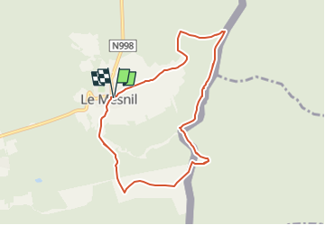
Tocht Stappen van 8,4 km beschikbaar op Wallonië, Namen, Viroinval. Deze tocht wordt voorgesteld door Desrumaux.
Beschrijving
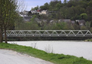
Charmante balade dans la commune de Viroinval au départ du village de Le Mesnil vers le hameau La Folie avec une petite incursion sue le territoire français.
Plaatsbepaling
Land:
Belgium
Regio :
Wallonië
Departement/Provincie :
Namen
Gemeente :
Viroinval
Locatie:
Unknown
Vertrek:(Dec)
Vertrek:(UTM)
619739 ; 5543443 (31U) N.
Opmerkingen
Wandeltochten in de omgeving
![Stappen Stappen](https://static1.geolcdn.com/sitytour/trail-icons/101.png)
Le Trou du Diable à Oignies en Thiérache
Stappen
Heel gemakkelijk
(4)
Viroinval,
Wallonië,
Namen,
Belgium
![](/images/other/stat-length.png)
6,4 km | 9,1 km-effort
2h 32min
![](https://static1.geolcdn.com/siteimages/upload/files/16400158638029165_repeat_loop_refresh_sync_direction_icon.png)
Ja
![Tocht Stappen Viroinval - RF-Na-12 Oignies - Grande-boucle - Photo](https://media.geolcdn.com/t/375/260/ext.jpg?maxdim=2&url=https%3A%2F%2Fstatic1.geolcdn.com%2Fsiteimages%2Fupload%2Ffiles%2F1553511878bg_sport_marche.png)
![Stappen Stappen](https://static1.geolcdn.com/sitytour/trail-icons/101.png)
RF-Na-12 Oignies - Grande-boucle
Stappen
Medium
(1)
Viroinval,
Wallonië,
Namen,
Belgium
![](/images/other/stat-length.png)
11 km | 14,2 km-effort
3h 2min
![](https://static1.geolcdn.com/siteimages/upload/files/16400158638029165_repeat_loop_refresh_sync_direction_icon.png)
Ja
![Tocht Noords wandelen Viroinval - VNW - Olloy-sur-viroin - 1 Fond de chênaux - Photo](https://media.geolcdn.com/t/375/260/ext.jpg?maxdim=2&url=https%3A%2F%2Fservices.sitytrail.com%2FGeolivesWS%2FDownloadMedia.ashx%3FTrailID%3D506311%26Media%3Dd545e250-2fab-40c7-9597-5dc8503503aa.jpg)
![Noords wandelen Noords wandelen](https://static1.geolcdn.com/sitytour/trail-icons/102.png)
VNW - Olloy-sur-viroin - 1 Fond de chênaux
Noords wandelen
Medium
(1)
Viroinval,
Wallonië,
Namen,
Belgium
![](/images/other/stat-length.png)
5 km | 6,5 km-effort
1h 3min
![](https://static1.geolcdn.com/siteimages/upload/files/16400158638029165_repeat_loop_refresh_sync_direction_icon.png)
Ja
![Tocht Stappen Viroinval - Autour de vierves sur viroin - Photo](https://media.geolcdn.com/t/375/260/ext.jpg?maxdim=2&url=https%3A%2F%2Fservices.sitytrail.com%2FGeolivesWS%2FDownloadMedia.ashx%3FTrailID%3D397913%26Media%3Dc658aef5-a80f-4049-a1f4-7bf0528ed5f1.JPG)
![Stappen Stappen](https://static1.geolcdn.com/sitytour/trail-icons/101.png)
Autour de vierves sur viroin
Stappen
Medium
(3)
Viroinval,
Wallonië,
Namen,
Belgium
![](/images/other/stat-length.png)
11 km | 14,6 km-effort
3h 10min
![](https://static1.geolcdn.com/siteimages/upload/files/16400158638029165_repeat_loop_refresh_sync_direction_icon.png)
Ja
![Tocht Stappen Viroinval - Balade à Le Mesnil - Viroinval - Photo](https://media.geolcdn.com/t/375/260/040808b9-fcd8-4fc3-8c4a-eb6f326e6772.jpeg&format=jpg&maxdim=2)
![Stappen Stappen](https://static1.geolcdn.com/sitytour/trail-icons/101.png)
Balade à Le Mesnil - Viroinval
Stappen
Gemakkelijk
Viroinval,
Wallonië,
Namen,
Belgium
![](/images/other/stat-length.png)
3,6 km | 4,8 km-effort
2h 16min
![](https://static1.geolcdn.com/siteimages/upload/files/16400158638029165_repeat_loop_refresh_sync_direction_icon.png)
Ja
![Tocht Stappen Viroinval - Balade dans le Viroinval - Olloy - Photo](https://media.geolcdn.com/t/375/260/c6d33371-3ecb-4ffa-ae45-9aaa97ba85ec.jpeg&format=jpg&maxdim=2)
![Stappen Stappen](https://static1.geolcdn.com/sitytour/trail-icons/101.png)
Balade dans le Viroinval - Olloy
Stappen
Moeilijk
Viroinval,
Wallonië,
Namen,
Belgium
![](/images/other/stat-length.png)
9,7 km | 13,2 km-effort
2h 59min
![](https://static1.geolcdn.com/siteimages/upload/files/16400158638029165_repeat_loop_refresh_sync_direction_icon.png)
Ja
![Tocht Stappen Viroinval - Balade à Oignies-en-Thiérache - Le Ry d'Alise - Photo](https://media.geolcdn.com/t/375/260/87d4fc47-9859-4088-b6f4-a15d14542517.jpeg&format=jpg&maxdim=2)
![Stappen Stappen](https://static1.geolcdn.com/sitytour/trail-icons/101.png)
Balade à Oignies-en-Thiérache - Le Ry d'Alise
Stappen
Medium
Viroinval,
Wallonië,
Namen,
Belgium
![](/images/other/stat-length.png)
8,6 km | 11,8 km-effort
2h 40min
![](https://static1.geolcdn.com/siteimages/upload/files/16400158638029165_repeat_loop_refresh_sync_direction_icon.png)
Ja
![Tocht Te voet Haybes - Les Sentiers des Crêtes - Photo](https://media.geolcdn.com/t/375/260/6b94c5c3-dc13-4c48-9664-900aed09082a.jpeg&format=jpg&maxdim=2)
![Te voet Te voet](https://static1.geolcdn.com/sitytour/trail-icons/100.png)
Les Sentiers des Crêtes
Te voet
Gemakkelijk
Haybes,
Grand Est,
Ardennes,
France
![](/images/other/stat-length.png)
14,1 km | 19,5 km-effort
4h 25min
![](https://static1.geolcdn.com/siteimages/upload/files/16400158638029165_repeat_loop_refresh_sync_direction_icon.png)
Neen
![Tocht Te voet Haybes - La Roche de Madame de Cormont - Photo](https://media.geolcdn.com/t/375/260/84d10620-5baa-43f3-9d62-58a472020b42.jpeg&format=jpg&maxdim=2)
![Te voet Te voet](https://static1.geolcdn.com/sitytour/trail-icons/100.png)
La Roche de Madame de Cormont
Te voet
Gemakkelijk
Haybes,
Grand Est,
Ardennes,
France
![](/images/other/stat-length.png)
8,4 km | 11,8 km-effort
2h 41min
![](https://static1.geolcdn.com/siteimages/upload/files/16400158638029165_repeat_loop_refresh_sync_direction_icon.png)
Ja