Tocht Stappen Soulaines-Dhuys - Soulaines-Dhuys (10) - Promenade de la Dhuys - Photo

Soulaines-Dhuys (10) - Promenade de la Dhuys

 temmichel
temmichel

Gebruiker

© OpenStreetMap contributors
Lengte
Lengte
10,7 km
Max. hoogte
Max. hoogte
195 m
Positief hoogteverschil
119 m
Km-Effort
Km-Effort  
12,3 km
Min. hoogte
Min. hoogte
136 m
Negatief hoogteverschil
119 m
Boucle
Boucle
Ja
Datum van aanmaak :
2024-03-16 15:00:22.256
Laatste wijziging :
2024-03-16 15:00:22.256

(0 Bericht)

Stappen
Stappen
2h47
Moeilijkheid : Moeilijk

Scan deze QR-code om de tocht te openen in de SityTrail-applicatie

Gratisgps-wandelapplicatie

Logo SityTrail SityTrail

IGN / Geografische instituten

SityTrail uit de App Store downloaden SityTrail uit Google Play downloaden

Logo SityTrail SityTrail World

De wereld gaat voor u open

SityTrail uit de App Store downloaden SityTrail uit Google Play downloaden SityTrail op Huawei AppGallery downloaden

Over ons

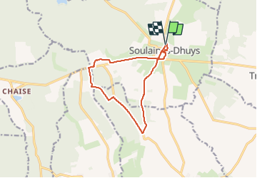
Tocht Stappen van 10,7 km beschikbaar op Grand Est, Aube, Soulaines-Dhuys. Deze tocht wordt voorgesteld door temmichel.

Hoogteprofiel

Plaatsbepaling

Land:
France
Regio :
Grand Est
Departement/Provincie :
Aube
Gemeente :
Soulaines-Dhuys
Locatie:
Unknown
Vertrek:(UTM)
628446 ; 5359625 (31U) N.

Wandeltochten in de omgeving

Tocht Fiets Soulaines-Dhuys - Des coteaux du Champagne aux sources de la Dhuys - Soulaines Dhuys - Photo
Fiets
tracegps

Fiets

Medium
Soulaines-Dhuys, Grand Est, Aube, France
58 km | 67 km-effort
3h 0min
Ja


Sluiten
Mijn abonnementen