


Rizières de Batag

tbourany
Gebruiker

Lengte
21 km

Max. hoogte
1318 m

Positief hoogteverschil
1149 m
Km-Effort
36 km

Min. hoogte
809 m

Negatief hoogteverschil
924 m
Boucle
Neen
Datum van aanmaak :
2024-02-29 01:58:11.765
Laatste wijziging :
2024-02-29 08:43:29.174
2h50
Moeilijkheid : Gemakkelijk

Gratisgps-wandelapplicatie
 SityTrail
IGN / Geografische instituten
SityTrail World
De wereld gaat voor u open
Over ons
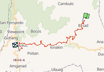
Tocht Stappen van 21 km beschikbaar op Ifugao, Banaue. Deze tocht wordt voorgesteld door tbourany.
Beschrijving
à pied plus retour en voiture
Foto's

Plaatsbepaling
Land:
Philippines
Regio :
Ifugao
Departement/Provincie :
Banaue
Gemeente :
Unknown
Locatie:
Unknown
Vertrek:(Dec)
Vertrek:(UTM)
301424 ; 1873581 (51Q) N.
Opmerkingen
Wandeltochten in de omgeving