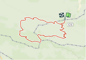
![](/images/other/stat-length.png)
![Tocht Izeste - 2024-02-21_14h46m12_le-bersaut-1368-m-en-boucle-par-loudenouste - Photo](https://media.geolcdn.com/t/1900/400/ext.pjpeg?maxdim=2&url=https%3A%2F%2Fsecurestorage.geolives.com%2Fsitytour%2Ftrail-bg%2Fdefault.jpg)
2024-02-21_14h46m12_le-bersaut-1368-m-en-boucle-par-loudenouste
PASTIER
Gebruiker
![Lengte](/images/other/stat-length.png)
![Boucle](https://static1.geolcdn.com/siteimages/upload/files/16400158638029165_repeat_loop_refresh_sync_direction_icon.png)
![Scan deze QR-code om de tocht te openen in de SityTrail-applicatie](https://capi.geolives.com/qq0zvz2zws4bq2lad0pu/sitytour/trails/3957518/qr.png?size=200)
Gratisgps-wandelapplicatie
Over ons
Tocht van 11,5 km beschikbaar op Nieuw-Aquitanië, Pyrénées-Atlantiques, Izeste. Deze tocht wordt voorgesteld door PASTIER.
Beschrijving
Le Bersaut en boucle depuis le plateau du Zoum. Monter à la cabane de l'Azercou d'Iseste
par le sentier des chasseurs. L'arrivée au sommet du Bersaut peu se faire par l'arrête Nord Ouest.
Descendre sur col de Houn Barrade et se diriger Ouest pour rejoindre la cabane de Castillou. Toujours plein Ouest vous passerez devant le complexe pastoral de l'Azerque d'Arudy et au col tout proche, plongeur plein Nord dans le vallon de Leignères bien suivre la trace qui va vous mènera à la fontaine des trois auges. A partir de ce passage le sentier est facile à suivre jusqu'au croisement de la piste descendant des cabanes d'Arudy.
Après avoir traversé cette piste, il ne vous restera qu'à suivre le sentier jusqu'au col d'Azus et ensuite le plateau du Zoum et la boucle est bouclée.
Le col d'Azus n'est pas mentionné sur toutes les cartes, il se trouve à la côte 826 m.
Cette trace est sure, nous y sommes passés aujourd'hui.
A faire par beau temps et si vous ne connaissez pas trop bien le secteur, la trace vous aidera.
Plaatsbepaling
Opmerkingen
Wandeltochten in de omgeving
![Tocht Stappen Louvie-Juzon - Soum de las Picarras Montagne du Rey - Photo](https://media.geolcdn.com/t/375/260/ext.jpg?maxdim=2&url=https%3A%2F%2Fservices.sitytrail.com%2FGeolivesWS%2FDownloadMedia.ashx%3FTrailID%3D541294%26Media%3Dfix__20160320134039.jpg)
![Stappen Stappen](https://static1.geolcdn.com/sitytour/trail-icons/101.png)
Stappen
![](/images/other/stat-length.png)
![](https://static1.geolcdn.com/siteimages/upload/files/16400158638029165_repeat_loop_refresh_sync_direction_icon.png)
![Tocht Stappen Bielle - BIELLE l arriu Mage reco 3443541 - Photo](https://media.geolcdn.com/t/375/260/85ef7966-54fd-44d2-aeee-6b5bc4ac7165.jpg&format=jpg&maxdim=2)
![Stappen Stappen](https://static1.geolcdn.com/sitytour/trail-icons/101.png)
Stappen
![](/images/other/stat-length.png)
![](https://static1.geolcdn.com/siteimages/upload/files/16400158638029165_repeat_loop_refresh_sync_direction_icon.png)
![Tocht Te voet Bielle - L'Arriu-Mage - Photo](https://media.geolcdn.com/t/375/260/9d640f1d-cca3-4d6c-b124-0b8f06a68e5a.jpeg&format=jpg&maxdim=2)
![Te voet Te voet](https://static1.geolcdn.com/sitytour/trail-icons/100.png)
Te voet
![](/images/other/stat-length.png)
![](https://static1.geolcdn.com/siteimages/upload/files/16400158638029165_repeat_loop_refresh_sync_direction_icon.png)
![Tocht Te voet Bilhères - Les cercles de pierre (Bilhères) - Photo](https://media.geolcdn.com/t/375/260/d1f3f786-1fe8-47a8-af2d-8ff90104ea03.jpeg&format=jpg&maxdim=2)
![Te voet Te voet](https://static1.geolcdn.com/sitytour/trail-icons/100.png)
Te voet
![](/images/other/stat-length.png)
![](https://static1.geolcdn.com/siteimages/upload/files/16400158638029165_repeat_loop_refresh_sync_direction_icon.png)
![Tocht Te voet Bilhères - Les cabanes de Lasbordes - Photo](https://media.geolcdn.com/t/375/260/6d402dc4-6faf-449a-b98e-9a6932ddd2f6.jpeg&format=jpg&maxdim=2)
![Te voet Te voet](https://static1.geolcdn.com/sitytour/trail-icons/100.png)
Te voet
![](/images/other/stat-length.png)
![](https://static1.geolcdn.com/siteimages/upload/files/16400158638029165_repeat_loop_refresh_sync_direction_icon.png)
![Tocht Te voet Louvie-Juzon - Le piémont du Rey - Photo](https://media.geolcdn.com/t/375/260/f491a556-8ecd-4525-a2fc-b2b6d591e533.jpeg&format=jpg&maxdim=2)
![Te voet Te voet](https://static1.geolcdn.com/sitytour/trail-icons/100.png)
Te voet
![](/images/other/stat-length.png)
![](https://static1.geolcdn.com/siteimages/upload/files/16400158638029165_repeat_loop_refresh_sync_direction_icon.png)
![Tocht Te voet Arudy - Le tour du bassin d'Arudy - Photo](https://media.geolcdn.com/t/375/260/f77d5769-a1f2-499c-9920-96e8d227d4fb.jpeg&format=jpg&maxdim=2)
![Te voet Te voet](https://static1.geolcdn.com/sitytour/trail-icons/100.png)
Te voet
![](/images/other/stat-length.png)
![](https://static1.geolcdn.com/siteimages/upload/files/16400158638029165_repeat_loop_refresh_sync_direction_icon.png)
![Tocht Te voet Sainte-Colome - Les buis - Photo](https://media.geolcdn.com/t/375/260/4276e983-4156-4966-8238-f2764987fcc4.jpeg&format=jpg&maxdim=2)
![Te voet Te voet](https://static1.geolcdn.com/sitytour/trail-icons/100.png)
Te voet
![](/images/other/stat-length.png)
![](https://static1.geolcdn.com/siteimages/upload/files/16400158638029165_repeat_loop_refresh_sync_direction_icon.png)
![Tocht Te voet Bilhères - Le Turon de Técouère - Photo](https://media.geolcdn.com/t/375/260/b6cd5576-3b7b-4d3a-b695-7d81816e4fdf.jpeg&format=jpg&maxdim=2)
![Te voet Te voet](https://static1.geolcdn.com/sitytour/trail-icons/100.png)
Te voet
![](/images/other/stat-length.png)
![](https://static1.geolcdn.com/siteimages/upload/files/16400158638029165_repeat_loop_refresh_sync_direction_icon.png)