![](/images/other/stat-length.png)
![Tocht Te voet Boulazac Isle Manoire - Boulazac Lesparat - Photo](https://media.geolcdn.com/t/1900/400/ext.pjpeg?maxdim=2&url=https%3A%2F%2Fstatic1.geolcdn.com%2Fsiteimages%2Fupload%2Ffiles%2F1545311037marcheuse_200dpi.jpg)
Boulazac Lesparat
audier
Gebruiker
![Lengte](/images/other/stat-length.png)
Lengte
10,6 km
![Max. hoogte](https://static1.geolcdn.com/siteimages/upload/files/1508320355ic_sort_altitude_max_24dp.png)
Max. hoogte
185 m
![Positief hoogteverschil](https://static1.geolcdn.com/siteimages/upload/files/1508320355ic_sort_den_pos_24dp.png)
Positief hoogteverschil
149 m
![Km-Effort](/images/other/stat-length.png)
Km-Effort
12,6 km
![Min. hoogte](https://static1.geolcdn.com/siteimages/upload/files/1508320355ic_sort_altitude_min_24dp.png)
Min. hoogte
85 m
![Negatief hoogteverschil](https://static1.geolcdn.com/siteimages/upload/files/1508320355ic_sort_den_neg_24dp.png)
Negatief hoogteverschil
150 m
![Boucle](https://static1.geolcdn.com/siteimages/upload/files/16400158638029165_repeat_loop_refresh_sync_direction_icon.png)
Boucle
Ja
Datum van aanmaak :
2024-02-17 17:41:18.023
Laatste wijziging :
2024-02-17 17:50:24.625
![Te voet](https://static1.geolcdn.com/sitytour/trail-icons/100.png)
2h52
Moeilijkheid : Gemakkelijk
![Scan deze QR-code om de tocht te openen in de SityTrail-applicatie](https://capi.geolives.com/qq0zvz2zws4bq2lad0pu/sitytour/trails/3953367/qr.png?size=200)
Gratisgps-wandelapplicatie
Over ons
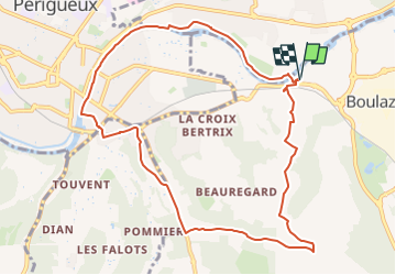
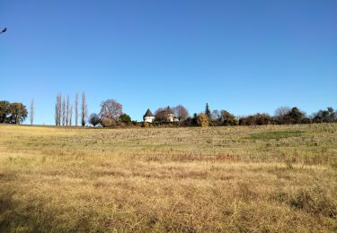
Tocht Te voet van 10,6 km beschikbaar op Nieuw-Aquitanië, Dordogne, Boulazac Isle Manoire. Deze tocht wordt voorgesteld door audier.
Beschrijving
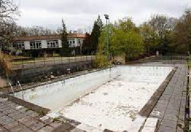
Randonnée urbaine, au départ de la passerelle Jean Ferrat ,point de vue sur la ville de Périgueux. Le parcours se termine par la voie verte le long de la rivière L'Isle.
Plaatsbepaling
Land:
France
Regio :
Nieuw-Aquitanië
Departement/Provincie :
Dordogne
Gemeente :
Boulazac Isle Manoire
Locatie:
Boulazac
Vertrek:(Dec)
Vertrek:(UTM)
323770 ; 5005684 (31T) N.
Opmerkingen
Wandeltochten in de omgeving
![Tocht Stappen Boulazac Isle Manoire - Atur - Photo](https://media.geolcdn.com/t/375/260/ext.jpg?maxdim=2&url=https%3A%2F%2Fstatic1.geolcdn.com%2Fsiteimages%2Fupload%2Ffiles%2F1553511878bg_sport_marche.png)
![Stappen Stappen](https://static1.geolcdn.com/sitytour/trail-icons/101.png)
Atur
Stappen
Gemakkelijk
(1)
Boulazac Isle Manoire,
Nieuw-Aquitanië,
Dordogne,
France
![](/images/other/stat-length.png)
12,5 km | 15,8 km-effort
3h 23min
![](https://static1.geolcdn.com/siteimages/upload/files/16400158638029165_repeat_loop_refresh_sync_direction_icon.png)
Ja
![Tocht Stappen Trélissac - Trélissac Puyconteau 10km - Photo](https://media.geolcdn.com/t/375/260/ext.jpg?maxdim=2&url=https%3A%2F%2Fstatic1.geolcdn.com%2Fsiteimages%2Fupload%2Ffiles%2F1553511878bg_sport_marche.png)
![Stappen Stappen](https://static1.geolcdn.com/sitytour/trail-icons/101.png)
Trélissac Puyconteau 10km
Stappen
Gemakkelijk
(2)
Trélissac,
Nieuw-Aquitanië,
Dordogne,
France
![](/images/other/stat-length.png)
9,7 km | 12,7 km-effort
2h 44min
![](https://static1.geolcdn.com/siteimages/upload/files/16400158638029165_repeat_loop_refresh_sync_direction_icon.png)
Ja
![Tocht Noords wandelen Trélissac - petite - Photo](https://media.geolcdn.com/t/375/260/ext.jpg?maxdim=2&url=https%3A%2F%2Fstatic1.geolcdn.com%2Fsiteimages%2Fupload%2Ffiles%2F1545311037marcheuse_200dpi.jpg)
![Noords wandelen Noords wandelen](https://static1.geolcdn.com/sitytour/trail-icons/102.png)
petite
Noords wandelen
Heel gemakkelijk
(1)
Trélissac,
Nieuw-Aquitanië,
Dordogne,
France
![](/images/other/stat-length.png)
8,6 km | 11,7 km-effort
1h 59min
![](https://static1.geolcdn.com/siteimages/upload/files/16400158638029165_repeat_loop_refresh_sync_direction_icon.png)
Neen
![Tocht Stappen Boulazac Isle Manoire - Boulazac à partir du Palio - Photo](https://media.geolcdn.com/t/375/260/ext.jpg?maxdim=2&url=https%3A%2F%2Fservices.sitytrail.com%2FGeolivesWS%2FDownloadMedia.ashx%3FTrailID%3D317879%26Media%3D17272_6.jpg)
![Stappen Stappen](https://static1.geolcdn.com/sitytour/trail-icons/101.png)
Boulazac à partir du Palio
Stappen
Medium
(1)
Boulazac Isle Manoire,
Nieuw-Aquitanië,
Dordogne,
France
![](/images/other/stat-length.png)
7,3 km | 9 km-effort
1h 45min
![](https://static1.geolcdn.com/siteimages/upload/files/16400158638029165_repeat_loop_refresh_sync_direction_icon.png)
Ja
![Tocht Stappen Boulazac Isle Manoire - Octobre rose Boulazac 2022 - Photo](https://media.geolcdn.com/t/375/260/e41a1f45-65e7-47fa-b801-6540904164c7.jpg&format=jpg&maxdim=2)
![Stappen Stappen](https://static1.geolcdn.com/sitytour/trail-icons/101.png)
Octobre rose Boulazac 2022
Stappen
Gemakkelijk
Boulazac Isle Manoire,
Nieuw-Aquitanië,
Dordogne,
France
![](/images/other/stat-length.png)
7,7 km | 8,9 km-effort
1h 42min
![](https://static1.geolcdn.com/siteimages/upload/files/16400158638029165_repeat_loop_refresh_sync_direction_icon.png)
Ja
![Tocht Stappen Champcevinel - champcevinel - Photo](https://media.geolcdn.com/t/375/260/ee6533d5-1951-437a-84ea-112f8c5e298d.jpg&format=jpg&maxdim=2)
![Stappen Stappen](https://static1.geolcdn.com/sitytour/trail-icons/101.png)
champcevinel
Stappen
Moeilijk
Champcevinel,
Nieuw-Aquitanië,
Dordogne,
France
![](/images/other/stat-length.png)
9,7 km | 12,3 km-effort
2h 48min
![](https://static1.geolcdn.com/siteimages/upload/files/16400158638029165_repeat_loop_refresh_sync_direction_icon.png)
Ja
![Tocht Stappen Boulazac Isle Manoire - Saint Laurent sur Manoire - Photo](https://media.geolcdn.com/t/375/260/ebe685e6-5319-4e99-8153-a55006b30e22.jpg&format=jpg&maxdim=2)
![Stappen Stappen](https://static1.geolcdn.com/sitytour/trail-icons/101.png)
Saint Laurent sur Manoire
Stappen
Moeilijk
(1)
Boulazac Isle Manoire,
Nieuw-Aquitanië,
Dordogne,
France
![](/images/other/stat-length.png)
11,2 km | 14,1 km-effort
3h 12min
![](https://static1.geolcdn.com/siteimages/upload/files/16400158638029165_repeat_loop_refresh_sync_direction_icon.png)
Ja
![Tocht Stappen Trélissac - Boucle de Lauterie insolite - Photo](https://media.geolcdn.com/t/375/260/a0da6d9a-9953-4a09-b76c-865d9abf1482.jpg&format=jpg&maxdim=2)
![Stappen Stappen](https://static1.geolcdn.com/sitytour/trail-icons/101.png)
Boucle de Lauterie insolite
Stappen
Gemakkelijk
Trélissac,
Nieuw-Aquitanië,
Dordogne,
France
![](/images/other/stat-length.png)
10,9 km | 14,6 km-effort
3h 28min
![](https://static1.geolcdn.com/siteimages/upload/files/16400158638029165_repeat_loop_refresh_sync_direction_icon.png)
Ja
![Tocht Stappen Trélissac - Boucle de Trélissac - Photo](https://media.geolcdn.com/t/375/260/8862f11b-d47d-4a08-be4b-811541867e99.jpg&format=jpg&maxdim=2)
![Stappen Stappen](https://static1.geolcdn.com/sitytour/trail-icons/101.png)
Boucle de Trélissac
Stappen
Moeilijk
Trélissac,
Nieuw-Aquitanië,
Dordogne,
France
![](/images/other/stat-length.png)
13,5 km | 17,7 km-effort
4h 1min
![](https://static1.geolcdn.com/siteimages/upload/files/16400158638029165_repeat_loop_refresh_sync_direction_icon.png)
Ja