![](/images/other/stat-length.png)
![Tocht Paard Vimartin-sur-Orthe - Chevaux du Montaigu 8 mars 2015 - Photo](https://media.geolcdn.com/t/1900/400/ext.pjpeg?maxdim=2&url=https%3A%2F%2Fstatic1.geolcdn.com%2Fsiteimages%2Fupload%2Ffiles%2F1524743154cheval.jpg)
Chevaux du Montaigu 8 mars 2015
mimi53
Gebruiker
![Lengte](/images/other/stat-length.png)
Lengte
30 km
![Max. hoogte](https://static1.geolcdn.com/siteimages/upload/files/1508320355ic_sort_altitude_max_24dp.png)
Max. hoogte
281 m
![Positief hoogteverschil](https://static1.geolcdn.com/siteimages/upload/files/1508320355ic_sort_den_pos_24dp.png)
Positief hoogteverschil
576 m
![Km-Effort](/images/other/stat-length.png)
Km-Effort
38 km
![Min. hoogte](https://static1.geolcdn.com/siteimages/upload/files/1508320355ic_sort_altitude_min_24dp.png)
Min. hoogte
130 m
![Negatief hoogteverschil](https://static1.geolcdn.com/siteimages/upload/files/1508320355ic_sort_den_neg_24dp.png)
Negatief hoogteverschil
576 m
![Boucle](https://static1.geolcdn.com/siteimages/upload/files/16400158638029165_repeat_loop_refresh_sync_direction_icon.png)
Boucle
Ja
Datum van aanmaak :
2019-02-23 20:41:44.698
Laatste wijziging :
2019-02-23 20:41:44.759
![Paard](https://static1.geolcdn.com/sitytour/trail-icons/300.png)
4h40
Moeilijkheid : Medium
![Scan deze QR-code om de tocht te openen in de SityTrail-applicatie](https://capi.geolives.com/qq0zvz2zws4bq2lad0pu/sitytour/trails/393860/qr.png?size=200)
Gratisgps-wandelapplicatie
Over ons
Tocht Paard van 30 km beschikbaar op Pays de la Loire, Mayenne, Vimartin-sur-Orthe. Deze tocht wordt voorgesteld door mimi53.
Beschrijving
Très belle randonnée à cheval, pour les cavaliers du Montaigu, au départ de St Martin de Connée, beaucoup de chemin, forêt, ruisseau et traversé d'un gué (L'Orthe)
Plaatsbepaling
Land:
France
Regio :
Pays de la Loire
Departement/Provincie :
Mayenne
Gemeente :
Vimartin-sur-Orthe
Locatie:
Unknown
Vertrek:(Dec)
Vertrek:(UTM)
706750 ; 5343835 (30U) N.
Opmerkingen
Wandeltochten in de omgeving
![Tocht Te voet Vimartin-sur-Orthe - Circuit de Saint-Pierre-sur-Orthe - Photo](https://media.geolcdn.com/t/375/260/5ccd96ba-4c9a-464a-ada8-2bed6fab63b7.jpeg&format=jpg&maxdim=2)
![Te voet Te voet](https://static1.geolcdn.com/sitytour/trail-icons/100.png)
Circuit de Saint-Pierre-sur-Orthe
Te voet
Medium
Vimartin-sur-Orthe,
Pays de la Loire,
Mayenne,
France
![](/images/other/stat-length.png)
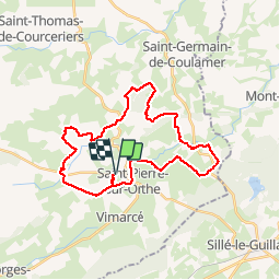
18,8 km | 24 km-effort
5h 30min
![](https://static1.geolcdn.com/siteimages/upload/files/16400158638029165_repeat_loop_refresh_sync_direction_icon.png)
Ja
![Tocht Te voet Vimartin-sur-Orthe - Circuit de Saint-Martin-de-Connée - Photo](https://media.geolcdn.com/t/375/260/88a89c42-2365-41e9-9d6f-13478c919f37.jpeg&format=jpg&maxdim=2)
![Te voet Te voet](https://static1.geolcdn.com/sitytour/trail-icons/100.png)
Circuit de Saint-Martin-de-Connée
Te voet
Medium
Vimartin-sur-Orthe,
Pays de la Loire,
Mayenne,
France
![](/images/other/stat-length.png)
16,3 km | 21 km-effort
4h 39min
![](https://static1.geolcdn.com/siteimages/upload/files/16400158638029165_repeat_loop_refresh_sync_direction_icon.png)
Ja
![Tocht Te voet Saint-Germain-de-Coulamer - Sentier de Bel Air (b) - Photo](https://media.geolcdn.com/t/375/260/ext.jpg?maxdim=2&url=https%3A%2F%2Fstatic1.geolcdn.com%2Fsiteimages%2Fupload%2Ffiles%2F1545311037marcheuse_200dpi.jpg)
![Te voet Te voet](https://static1.geolcdn.com/sitytour/trail-icons/100.png)
Sentier de Bel Air (b)
Te voet
Gemakkelijk
Saint-Germain-de-Coulamer,
Pays de la Loire,
Mayenne,
France
![](/images/other/stat-length.png)
4,9 km | 6,3 km-effort
1h 25min
![](https://static1.geolcdn.com/siteimages/upload/files/16400158638029165_repeat_loop_refresh_sync_direction_icon.png)
Ja
![Tocht Stappen Vimartin-sur-Orthe - Saint-Martin-de-Connée - La Chapelle Notre Dame du Chêne - Photo](https://media.geolcdn.com/t/375/260/ext.jpg?maxdim=2&url=https%3A%2F%2Fservices.sitytrail.com%2FGeolivesWS%2FDownloadMedia.ashx%3FTrailID%3D199706%26Media%3D4873f264-6305-4cb8-b808-595f1889411e.JPG)
![Stappen Stappen](https://static1.geolcdn.com/sitytour/trail-icons/101.png)
Saint-Martin-de-Connée - La Chapelle Notre Dame du Chêne
Stappen
Medium
Vimartin-sur-Orthe,
Pays de la Loire,
Mayenne,
France
![](/images/other/stat-length.png)
20 km | 25 km-effort
5h 23min
![](https://static1.geolcdn.com/siteimages/upload/files/16400158638029165_repeat_loop_refresh_sync_direction_icon.png)
Ja
![Tocht Auto Vimartin-sur-Orthe - 2022-11-19 SduC Sille le G - Photo](https://media.geolcdn.com/t/375/260/ext.jpg?maxdim=2&url=https%3A%2F%2Fstatic1.geolcdn.com%2Fsiteimages%2Fupload%2Ffiles%2F15247431544x4.jpg)
![Auto Auto](https://static1.geolcdn.com/sitytour/trail-icons/401.png)
2022-11-19 SduC Sille le G
Auto
Vimartin-sur-Orthe,
Pays de la Loire,
Mayenne,
France
![](/images/other/stat-length.png)
50 km | 61 km-effort
3h 39min
![](https://static1.geolcdn.com/siteimages/upload/files/16400158638029165_repeat_loop_refresh_sync_direction_icon.png)
Neen
![Tocht Te voet Vimartin-sur-Orthe - Circuit de Vimarcé - Photo](https://media.geolcdn.com/t/375/260/ext.jpg?maxdim=2&url=https%3A%2F%2Fstatic1.geolcdn.com%2Fsiteimages%2Fupload%2Ffiles%2F1545311037marcheuse_200dpi.jpg)
![Te voet Te voet](https://static1.geolcdn.com/sitytour/trail-icons/100.png)
Circuit de Vimarcé
Te voet
Gemakkelijk
Vimartin-sur-Orthe,
Pays de la Loire,
Mayenne,
France
![](/images/other/stat-length.png)
12,4 km | 15,7 km-effort
3h 33min
![](https://static1.geolcdn.com/siteimages/upload/files/16400158638029165_repeat_loop_refresh_sync_direction_icon.png)
Ja
![Tocht Noords wandelen Le Grez - Fr Le Grez 16-11 2019 - Photo](https://media.geolcdn.com/t/375/260/ext.jpg?maxdim=2&url=https%3A%2F%2Fstatic1.geolcdn.com%2Fsiteimages%2Fupload%2Ffiles%2F1545311037marcheuse_200dpi.jpg)
![Noords wandelen Noords wandelen](https://static1.geolcdn.com/sitytour/trail-icons/102.png)
Fr Le Grez 16-11 2019
Noords wandelen
Heel gemakkelijk
Le Grez,
Pays de la Loire,
Sarthe,
France
![](/images/other/stat-length.png)
10,8 km | 12,6 km-effort
2h 15min
![](https://static1.geolcdn.com/siteimages/upload/files/16400158638029165_repeat_loop_refresh_sync_direction_icon.png)
Ja
![Tocht Paard Vimartin-sur-Orthe - Chevaux du Montaigu_Sille_21 juin 2015 - Photo](https://media.geolcdn.com/t/375/260/ext.jpg?maxdim=2&url=https%3A%2F%2Fstatic1.geolcdn.com%2Fsiteimages%2Fupload%2Ffiles%2F1524743154cheval.jpg)
![Paard Paard](https://static1.geolcdn.com/sitytour/trail-icons/300.png)
Chevaux du Montaigu_Sille_21 juin 2015
Paard
Gemakkelijk
Vimartin-sur-Orthe,
Pays de la Loire,
Mayenne,
France
![](/images/other/stat-length.png)
30 km | 37 km-effort
4h 36min
![](https://static1.geolcdn.com/siteimages/upload/files/16400158638029165_repeat_loop_refresh_sync_direction_icon.png)
Ja
![Tocht Noords wandelen Vimartin-sur-Orthe - Fr 08-10-2024 Vimarcé. RS 8,8 km - Photo](https://media.geolcdn.com/t/375/260/ext.jpg?maxdim=2&url=https%3A%2F%2Fstatic1.geolcdn.com%2Fsiteimages%2Fupload%2Ffiles%2F1545311037marcheuse_200dpi.jpg)
![Noords wandelen Noords wandelen](https://static1.geolcdn.com/sitytour/trail-icons/102.png)
Fr 08-10-2024 Vimarcé. RS 8,8 km
Noords wandelen
Heel gemakkelijk
Vimartin-sur-Orthe,
Pays de la Loire,
Mayenne,
France
![](/images/other/stat-length.png)
8,8 km | 11,1 km-effort
2h 22min
![](https://static1.geolcdn.com/siteimages/upload/files/16400158638029165_repeat_loop_refresh_sync_direction_icon.png)
Ja