Tocht Stappen Hürth - Kurt 23 km - Photo
 Alain Williaume
Alain Williaume

Gebruiker

© OpenStreetMap contributors
Lengte
Lengte
23 km
Max. hoogte
Max. hoogte
131 m
Positief hoogteverschil
249 m
Km-Effort
Km-Effort  
27 km
Min. hoogte
Min. hoogte
68 m
Negatief hoogteverschil
248 m
Boucle
Boucle
Ja
Datum van aanmaak :
2024-01-28 07:54:04.0
Laatste wijziging :
2024-01-28 12:43:46.512

(0 Bericht)

Stappen
Stappen
4h48
Moeilijkheid : Gemakkelijk

Scan deze QR-code om de tocht te openen in de SityTrail-applicatie

Gratisgps-wandelapplicatie

Logo SityTrail SityTrail

IGN / Geografische instituten

SityTrail uit de App Store downloaden SityTrail uit Google Play downloaden

Logo SityTrail SityTrail World

De wereld gaat voor u open

SityTrail uit de App Store downloaden SityTrail uit Google Play downloaden SityTrail op Huawei AppGallery downloaden

Over ons

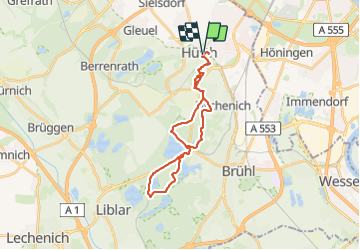
Tocht Stappen van 23 km beschikbaar op Noordrijn-Westfalen, Rhein-Erft-Kreis, Hürth. Deze tocht wordt voorgesteld door Alain Williaume.

Hoogteprofiel

Plaatsbepaling

Land:
Germany
Regio :
Noordrijn-Westfalen
Departement/Provincie :
Rhein-Erft-Kreis
Gemeente :
Hürth
Locatie:
Unknown
Vertrek:(Dec)
Vertrek:(UTM)
350853 ; 5638563 (32U) N.

Wandeltochten in de omgeving

Tocht Te voet Hürth - Ville A4 - Photo
Te voet
GUIDE+

Te voet

Gemakkelijk
Hürth, Noordrijn-Westfalen, Rhein-Erft-Kreis, Germany
4 km | 4,4 km-effort
1h 0min
Ja
Tocht Te voet Hürth - Otto-Maigler-Runde - Photo
Te voet
GUIDE+

Te voet

Gemakkelijk
Hürth, Noordrijn-Westfalen, Rhein-Erft-Kreis, Germany
10,7 km | 11,7 km-effort
2h 39min
Ja


Sluiten
Mijn abonnementen