Tocht Stappen Sainte-Léocadie - Refuge Pastoral de Sainte-Léocadie  - Photo

Refuge Pastoral de Sainte-Léocadie

 rene091957
rene091957

Gebruiker

© OpenStreetMap contributors
Lengte
Lengte
11,9 km
Max. hoogte
Max. hoogte
1782 m
Positief hoogteverschil
516 m
Km-Effort
Km-Effort  
18,8 km
Min. hoogte
Min. hoogte
1284 m
Negatief hoogteverschil
517 m
Boucle
Boucle
Ja
Datum van aanmaak :
2024-01-22 18:10:11.739
Laatste wijziging :
2024-01-22 18:29:24.678

(0 Bericht)

Stappen
Stappen
4h16
Moeilijkheid : Moeilijk

Scan deze QR-code om de tocht te openen in de SityTrail-applicatie

Gratisgps-wandelapplicatie

Logo SityTrail SityTrail

IGN / Geografische instituten

SityTrail uit de App Store downloaden SityTrail uit Google Play downloaden

Logo SityTrail SityTrail World

De wereld gaat voor u open

SityTrail uit de App Store downloaden SityTrail uit Google Play downloaden SityTrail op Huawei AppGallery downloaden

Over ons

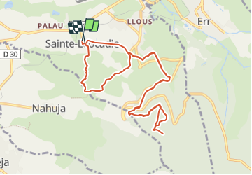
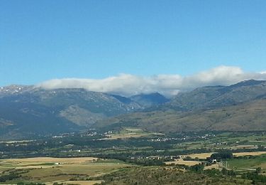
Tocht Stappen van 11,9 km beschikbaar op Occitanië, Pyrénées-Orientales, Sainte-Léocadie. Deze tocht wordt voorgesteld door rene091957.

Beschrijving

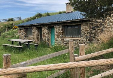
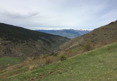
Départ au Parking de la mairie, direction Err, intersection GRP-GR36, Cases d'Amunt, Station de pompage Font Rabiola, aire de pique-nique, table d'orientation, Refuge Pastoral. Retour par le même chemin jusqu'à l'intersection GRP-GR36. Direction Nahuja, chemin à gauche après une intersection, descente vers le point de départ.

Hoogteprofiel

Plaatsbepaling

Land:
France
Regio :
Occitanië
Departement/Provincie :
Pyrénées-Orientales
Gemeente :
Sainte-Léocadie
Locatie:
Unknown
Vertrek:(UTM)
418000 ; 4698772 (31T) N.

Wandeltochten in de omgeving

Tocht Stappen Nahuja - boucle de Nahuja - Photo
Stappen
crijack

Stappen

Medium
(1)
Nahuja, Occitanië, Pyrénées-Orientales, France
11,8 km | 18,2 km-effort
2h 44min
Ja
Tocht sport Saillagouse - 20240623 Saillagouse -Err - Photo
sport
ThonyM

sport

Heel gemakkelijk
Saillagouse, Occitanië, Pyrénées-Orientales, France
11,9 km | 15,5 km-effort
Onbekend
Ja
Tocht Stappen Estavar - 20220328 Estavar-Tartassonne(?) - Photo
Stappen
ThonyM

Stappen

Medium
Estavar, Occitanië, Pyrénées-Orientales, France
14,8 km | 22 km-effort
3h 16min
Ja
Tocht Stappen Saillagouse - 20210627 à partir de Saillagouse  - Photo
Stappen
ThonyM

Stappen

Medium
(1)
Saillagouse, Occitanië, Pyrénées-Orientales, France
16,2 km | 26 km-effort
3h 47min
Ja
Tocht Stappen Valcebollère - Valcebollère chapelle Saint Barnabeu - Photo
Stappen
crijack

Stappen

Medium
Valcebollère, Occitanië, Pyrénées-Orientales, France
11,3 km | 17,4 km-effort
3h 27min
Ja
Tocht Stappen Valcebollère - Valcebollère chapelle Saint Barnabeu - Photo
Stappen
crijack

Stappen

Medium
Valcebollère, Occitanië, Pyrénées-Orientales, France
11,3 km | 17,4 km-effort
3h 27min
Ja
Tocht Stappen Err - d'Err à Bolquère - Photo
Stappen
gberger

Stappen

Gemakkelijk
Err, Occitanië, Pyrénées-Orientales, France
12,9 km | 18,5 km-effort
4h 10min
Neen
Tocht Stappen Sainte-Léocadie - la cerdagne se raconte - Photo
Stappen
carapitouille

Stappen

Gemakkelijk
(1)
Sainte-Léocadie, Occitanië, Pyrénées-Orientales, France
5,8 km | 7,5 km-effort
2h 4min
Neen
Tocht Sneeuwschoenen Err - Pas de Lladres - Err - Photo
Sneeuwschoenen
tracegps

Sneeuwschoenen

Moeilijk
Err, Occitanië, Pyrénées-Orientales, France
15,1 km | 28 km-effort
5h 0min
Ja


Sluiten
Mijn abonnementen