![](/images/other/stat-length.png)
![Tocht Stappen Rombach-le-Franc - trace - Photo](https://media.geolcdn.com/t/1900/400/ext.pjpeg?maxdim=2&url=https%3A%2F%2Fstatic1.geolcdn.com%2Fsiteimages%2Fupload%2Ffiles%2F1553511878bg_sport_marche.png)
trace
vaillantjm
Gebruiker
![Lengte](/images/other/stat-length.png)
Lengte
17,4 km
![Max. hoogte](https://static1.geolcdn.com/siteimages/upload/files/1508320355ic_sort_altitude_max_24dp.png)
Max. hoogte
780 m
![Positief hoogteverschil](https://static1.geolcdn.com/siteimages/upload/files/1508320355ic_sort_den_pos_24dp.png)
Positief hoogteverschil
678 m
![Km-Effort](/images/other/stat-length.png)
Km-Effort
26 km
![Min. hoogte](https://static1.geolcdn.com/siteimages/upload/files/1508320355ic_sort_altitude_min_24dp.png)
Min. hoogte
302 m
![Negatief hoogteverschil](https://static1.geolcdn.com/siteimages/upload/files/1508320355ic_sort_den_neg_24dp.png)
Negatief hoogteverschil
677 m
![Boucle](https://static1.geolcdn.com/siteimages/upload/files/16400158638029165_repeat_loop_refresh_sync_direction_icon.png)
Boucle
Ja
Datum van aanmaak :
2024-01-17 17:07:16.916
Laatste wijziging :
2024-04-09 12:08:23.459
![Stappen](https://static1.geolcdn.com/sitytour/trail-icons/101.png)
6h00
Moeilijkheid : Moeilijk
![Scan deze QR-code om de tocht te openen in de SityTrail-applicatie](https://capi.geolives.com/qq0zvz2zws4bq2lad0pu/sitytour/trails/3919183/qr.png?size=200)
Gratisgps-wandelapplicatie
Over ons
Tocht Stappen van 17,4 km beschikbaar op Grand Est, Haut-Rhin, Rombach-le-Franc. Deze tocht wordt voorgesteld door vaillantjm.
Beschrijving
La partie entre le col de Fouchy et le col de Noirceux est magnifique mais il faut faire avec 7 km de route asphaltée à la sortie et à l'entrée de Rombach. A vous de choisir!
Plaatsbepaling
Land:
France
Regio :
Grand Est
Departement/Provincie :
Haut-Rhin
Gemeente :
Rombach-le-Franc
Locatie:
Unknown
Vertrek:(Dec)
Vertrek:(UTM)
371082 ; 5349237 (32U) N.
Opmerkingen
Wandeltochten in de omgeving
![Tocht Stappen La Vancelle - 2020-05-21 Marche La Vancelle Boucle - Photo](https://media.geolcdn.com/t/375/260/45f73326-854e-41a0-95ea-dc1c83334d8a.jpg&format=jpg&maxdim=2)
![Stappen Stappen](https://static1.geolcdn.com/sitytour/trail-icons/101.png)
2020-05-21 Marche La Vancelle Boucle
Stappen
Heel gemakkelijk
La Vancelle,
Grand Est,
Bas-Rhin,
France
![](/images/other/stat-length.png)
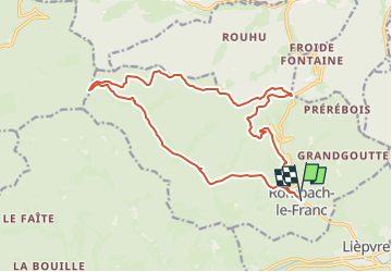
16,3 km | 26 km-effort
6h 41min
![](https://static1.geolcdn.com/siteimages/upload/files/16400158638029165_repeat_loop_refresh_sync_direction_icon.png)
Ja
![Tocht Stappen La Vancelle - 2015-01-02 Marche Rocher du Coucou Chateau Frankenbourg - Photo](https://media.geolcdn.com/t/375/260/ext.jpg?maxdim=2&url=https%3A%2F%2Fstatic1.geolcdn.com%2Fsiteimages%2Fupload%2Ffiles%2F1553511878bg_sport_marche.png)
![Stappen Stappen](https://static1.geolcdn.com/sitytour/trail-icons/101.png)
2015-01-02 Marche Rocher du Coucou Chateau Frankenbourg
Stappen
Gemakkelijk
(1)
La Vancelle,
Grand Est,
Bas-Rhin,
France
![](/images/other/stat-length.png)
10,9 km | 18,1 km-effort
3h 47min
![](https://static1.geolcdn.com/siteimages/upload/files/16400158638029165_repeat_loop_refresh_sync_direction_icon.png)
Ja
![Tocht Stappen Breitenau - 2024-07-23_20h26m34_G 12 - Photo](https://media.geolcdn.com/t/375/260/ext.jpg?maxdim=2&url=https%3A%2F%2Fstatic1.geolcdn.com%2Fsiteimages%2Fupload%2Ffiles%2F1553511878bg_sport_marche.png)
![Stappen Stappen](https://static1.geolcdn.com/sitytour/trail-icons/101.png)
2024-07-23_20h26m34_G 12
Stappen
Gemakkelijk
(1)
Breitenau,
Grand Est,
Bas-Rhin,
France
![](/images/other/stat-length.png)
15,4 km | 22 km-effort
4h 59min
![](https://static1.geolcdn.com/siteimages/upload/files/16400158638029165_repeat_loop_refresh_sync_direction_icon.png)
Ja
![Stappen Stappen](https://static1.geolcdn.com/sitytour/trail-icons/101.png)
20230309_BREITENAU_rando_Breitenau_Le Rocher du Coucou - Le Château du Franke...
Stappen
Medium
Breitenau,
Grand Est,
Bas-Rhin,
France
![](/images/other/stat-length.png)
14,5 km | 24 km-effort
5h 24min
![](https://static1.geolcdn.com/siteimages/upload/files/16400158638029165_repeat_loop_refresh_sync_direction_icon.png)
Ja
![Tocht Stappen Rombach-le-Franc - Col de Fouchy - Photo](https://media.geolcdn.com/t/375/260/d71f8170-2b95-4d63-8fe6-ab7a52c9f1d0.jpg&format=jpg&maxdim=2)
![Stappen Stappen](https://static1.geolcdn.com/sitytour/trail-icons/101.png)
Col de Fouchy
Stappen
Medium
Rombach-le-Franc,
Grand Est,
Haut-Rhin,
France
![](/images/other/stat-length.png)
11,8 km | 17,6 km-effort
3h 23min
![](https://static1.geolcdn.com/siteimages/upload/files/16400158638029165_repeat_loop_refresh_sync_direction_icon.png)
Ja
![Tocht Stappen Lièpvre - Liépvre - Roche des Fées, Roche de Chalmont, Rocher du Coucou, château du Frankenbourg - Photo](https://media.geolcdn.com/t/375/260/bc9e5781-8dbd-488c-b7a5-232842474208.jpg&format=jpg&maxdim=2)
![Stappen Stappen](https://static1.geolcdn.com/sitytour/trail-icons/101.png)
Liépvre - Roche des Fées, Roche de Chalmont, Rocher du Coucou, château du Fra...
Stappen
Moeilijk
Lièpvre,
Grand Est,
Haut-Rhin,
France
![](/images/other/stat-length.png)
19,4 km | 31 km-effort
5h 53min
![](https://static1.geolcdn.com/siteimages/upload/files/16400158638029165_repeat_loop_refresh_sync_direction_icon.png)
Ja
![Tocht Stappen La Vancelle - Les Hauts de La Vancelle - Photo](https://media.geolcdn.com/t/375/260/40e46161-9ab7-408e-ba32-8486e7e7679a.jpg&format=jpg&maxdim=2)
![Stappen Stappen](https://static1.geolcdn.com/sitytour/trail-icons/101.png)
Les Hauts de La Vancelle
Stappen
Medium
La Vancelle,
Grand Est,
Bas-Rhin,
France
![](/images/other/stat-length.png)
13,4 km | 21 km-effort
4h 39min
![](https://static1.geolcdn.com/siteimages/upload/files/16400158638029165_repeat_loop_refresh_sync_direction_icon.png)
Ja
![Tocht Stappen Breitenau - xc 191017 cv breitenau - Photo](https://media.geolcdn.com/t/375/260/ext.jpg?maxdim=2&url=https%3A%2F%2Fstatic1.geolcdn.com%2Fsiteimages%2Fupload%2Ffiles%2F1553511878bg_sport_marche.png)
![Stappen Stappen](https://static1.geolcdn.com/sitytour/trail-icons/101.png)
xc 191017 cv breitenau
Stappen
Heel gemakkelijk
(1)
Breitenau,
Grand Est,
Bas-Rhin,
France
![](/images/other/stat-length.png)
11,9 km | 18,3 km-effort
5h 6min
![](https://static1.geolcdn.com/siteimages/upload/files/16400158638029165_repeat_loop_refresh_sync_direction_icon.png)
Neen
![Tocht Stappen Rombach-le-Franc - Col de Fouchy - Photo](https://media.geolcdn.com/t/375/260/dcb97d14-f440-4cae-9665-7d2ebfddb5bb.jpg&format=jpg&maxdim=2)
![Stappen Stappen](https://static1.geolcdn.com/sitytour/trail-icons/101.png)
Col de Fouchy
Stappen
Medium
Rombach-le-Franc,
Grand Est,
Haut-Rhin,
France
![](/images/other/stat-length.png)
20 km | 29 km-effort
4h 47min
![](https://static1.geolcdn.com/siteimages/upload/files/16400158638029165_repeat_loop_refresh_sync_direction_icon.png)
Ja