![](/images/other/stat-length.png)
![Tocht Stappen Duclair - Mesnil-sous-Jumièges-PT-7,4KM - Photo](https://media.geolcdn.com/t/1900/400/ext.pjpeg?maxdim=2&url=https%3A%2F%2Fstatic1.geolcdn.com%2Fsiteimages%2Fupload%2Ffiles%2F1553511878bg_sport_marche.png)
Mesnil-sous-Jumièges-PT-7,4KM
philippe76
Gebruiker
![Lengte](/images/other/stat-length.png)
Lengte
7,3 km
![Max. hoogte](https://static1.geolcdn.com/siteimages/upload/files/1508320355ic_sort_altitude_max_24dp.png)
Max. hoogte
97 m
![Positief hoogteverschil](https://static1.geolcdn.com/siteimages/upload/files/1508320355ic_sort_den_pos_24dp.png)
Positief hoogteverschil
113 m
![Km-Effort](/images/other/stat-length.png)
Km-Effort
8,8 km
![Min. hoogte](https://static1.geolcdn.com/siteimages/upload/files/1508320355ic_sort_altitude_min_24dp.png)
Min. hoogte
5 m
![Negatief hoogteverschil](https://static1.geolcdn.com/siteimages/upload/files/1508320355ic_sort_den_neg_24dp.png)
Negatief hoogteverschil
106 m
![Boucle](https://static1.geolcdn.com/siteimages/upload/files/16400158638029165_repeat_loop_refresh_sync_direction_icon.png)
Boucle
Neen
Datum van aanmaak :
2016-03-09 00:00:00.0
Laatste wijziging :
2016-03-09 00:00:00.0
![Stappen](https://static1.geolcdn.com/sitytour/trail-icons/101.png)
1h54
Moeilijkheid : Gemakkelijk
![Scan deze QR-code om de tocht te openen in de SityTrail-applicatie](https://capi.geolives.com/qq0zvz2zws4bq2lad0pu/sitytour/trails/391268/qr.png?size=200)
Gratisgps-wandelapplicatie
Over ons
Tocht Stappen van 7,3 km beschikbaar op Normandië, Seine-Maritime, Duclair. Deze tocht wordt voorgesteld door philippe76.
Beschrijving
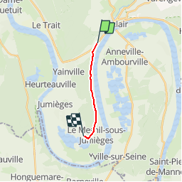
Départ à St Paul sur la D982, devant la Poste. traverser la D982 et rattraper le GR. TD et AG le GR 2 Variante jusqu'à La grande pierre. TD jusqu'au Manoir d'Agnes Sorel. AD jusqu'à l'entrée dde la Base Nautique.
Plaatsbepaling
Land:
France
Regio :
Normandië
Departement/Provincie :
Seine-Maritime
Gemeente :
Duclair
Locatie:
Unknown
Vertrek:(Dec)
Vertrek:(UTM)
344898 ; 5481920 (31U) N.
Opmerkingen
Wandeltochten in de omgeving
![Tocht Stappen Jumièges - 076-84-Jumièges 14Km La route des Fruits - Photo](https://media.geolcdn.com/t/375/260/e64b558b-b90d-49d1-a272-2fef28aac5a7.jpg&format=jpg&maxdim=2)
![Stappen Stappen](https://static1.geolcdn.com/sitytour/trail-icons/101.png)
076-84-Jumièges 14Km La route des Fruits
Stappen
Gemakkelijk
(1)
Jumièges,
Normandië,
Seine-Maritime,
France
![](/images/other/stat-length.png)
13,7 km | 14,9 km-effort
3h 19min
![](https://static1.geolcdn.com/siteimages/upload/files/16400158638029165_repeat_loop_refresh_sync_direction_icon.png)
Ja
![Tocht Stappen Duclair - Duclair 2 (80) - Photo](https://media.geolcdn.com/t/375/260/ext.jpg?maxdim=2&url=https%3A%2F%2Fstatic1.geolcdn.com%2Fsiteimages%2Fupload%2Ffiles%2F1553511878bg_sport_marche.png)
![Stappen Stappen](https://static1.geolcdn.com/sitytour/trail-icons/101.png)
Duclair 2 (80)
Stappen
Medium
(1)
Duclair,
Normandië,
Seine-Maritime,
France
![](/images/other/stat-length.png)
11,1 km | 13,8 km-effort
3h 1min
![](https://static1.geolcdn.com/siteimages/upload/files/16400158638029165_repeat_loop_refresh_sync_direction_icon.png)
Ja
![Tocht Stappen Bardouville - bardouville - Photo](https://media.geolcdn.com/t/375/260/ext.jpg?maxdim=2&url=https%3A%2F%2Fstatic1.geolcdn.com%2Fsiteimages%2Fupload%2Ffiles%2F1553511878bg_sport_marche.png)
![Stappen Stappen](https://static1.geolcdn.com/sitytour/trail-icons/101.png)
bardouville
Stappen
Heel gemakkelijk
(1)
Bardouville,
Normandië,
Seine-Maritime,
France
![](/images/other/stat-length.png)
6,1 km | 6,9 km-effort
1h 31min
![](https://static1.geolcdn.com/siteimages/upload/files/16400158638029165_repeat_loop_refresh_sync_direction_icon.png)
Ja
![Tocht Stappen Duclair - duclair - Photo](https://media.geolcdn.com/t/375/260/ext.jpg?maxdim=2&url=https%3A%2F%2Fstatic1.geolcdn.com%2Fsiteimages%2Fupload%2Ffiles%2F1553511878bg_sport_marche.png)
![Stappen Stappen](https://static1.geolcdn.com/sitytour/trail-icons/101.png)
duclair
Stappen
Medium
(1)
Duclair,
Normandië,
Seine-Maritime,
France
![](/images/other/stat-length.png)
11,8 km | 15,1 km-effort
Onbekend
![](https://static1.geolcdn.com/siteimages/upload/files/16400158638029165_repeat_loop_refresh_sync_direction_icon.png)
Ja
![Tocht Stappen Heurteauville - HONFLEUR 04 - La Sente aux Moines et Abbaye de Jumiêges (Normandie) - Photo](https://media.geolcdn.com/t/375/260/010082f5-0545-4d4b-952f-4f2094d18163.jpg&format=jpg&maxdim=2)
![Stappen Stappen](https://static1.geolcdn.com/sitytour/trail-icons/101.png)
HONFLEUR 04 - La Sente aux Moines et Abbaye de Jumiêges (Normandie)
Stappen
Medium
Heurteauville,
Normandië,
Seine-Maritime,
France
![](/images/other/stat-length.png)
19,9 km | 25 km-effort
6h 37min
![](https://static1.geolcdn.com/siteimages/upload/files/16400158638029165_repeat_loop_refresh_sync_direction_icon.png)
Neen
![Tocht Te voet Le Trait - Duclair maison forestiere - Photo](https://media.geolcdn.com/t/375/260/ext.jpg?maxdim=2&url=https%3A%2F%2Fstatic1.geolcdn.com%2Fsiteimages%2Fupload%2Ffiles%2F1545311037marcheuse_200dpi.jpg)
![Te voet Te voet](https://static1.geolcdn.com/sitytour/trail-icons/100.png)
Duclair maison forestiere
Te voet
Gemakkelijk
(1)
Le Trait,
Normandië,
Seine-Maritime,
France
![](/images/other/stat-length.png)
10,8 km | 13,4 km-effort
3h 2min
![](https://static1.geolcdn.com/siteimages/upload/files/16400158638029165_repeat_loop_refresh_sync_direction_icon.png)
Ja
![Stappen Stappen](https://static1.geolcdn.com/sitytour/trail-icons/101.png)
20230513-Yainville
Stappen
Medium
Yainville,
Normandië,
Seine-Maritime,
France
![](/images/other/stat-length.png)
12,4 km | 14 km-effort
3h 52min
![](https://static1.geolcdn.com/siteimages/upload/files/16400158638029165_repeat_loop_refresh_sync_direction_icon.png)
Ja
![Tocht Stappen Rives-en-Seine - saint marguerite sur duclair - Photo](https://media.geolcdn.com/t/375/260/e79a805c-23a8-4b82-8445-cd3cb02d88fd.jpg&format=jpg&maxdim=2)
![Stappen Stappen](https://static1.geolcdn.com/sitytour/trail-icons/101.png)
saint marguerite sur duclair
Stappen
Medium
Rives-en-Seine,
Normandië,
Seine-Maritime,
France
![](/images/other/stat-length.png)
6,6 km | 7,3 km-effort
2h 9min
![](https://static1.geolcdn.com/siteimages/upload/files/16400158638029165_repeat_loop_refresh_sync_direction_icon.png)
Ja
![Stappen Stappen](https://static1.geolcdn.com/sitytour/trail-icons/101.png)
20221103-Duclair Le Taillis
Stappen
Medium
Duclair,
Normandië,
Seine-Maritime,
France
![](/images/other/stat-length.png)
13,6 km | 17,5 km-effort
3h 53min
![](https://static1.geolcdn.com/siteimages/upload/files/16400158638029165_repeat_loop_refresh_sync_direction_icon.png)
Ja